 Fort San Andrea on Vignole | |
 Vignole Location in the Venetian Lagoon | |
| Geography | |
|---|---|
| Coordinates | 45°26′26″N 12°22′36″E / 45.440531°N 12.376779°E |
| Adjacent to | Venetian Lagoon |
| Area | 69.2 ha (171 acres) |
| Administration | |
| Region | Veneto |
| Province | Province of Venice |
Vignole (also Le Vignole) is an island in the Venetian Lagoon, northern Italy, with an area of 69.20 ha (171 acres). It is located north-east of Venice, between the islands of Sant'Erasmo and La Certosa.
Location
[edit]Vignole consists of two islands which are connected by a bridge. As with neighbouring Sant'Erasmo, Vignole has a small population most of whom work in agriculture. The eastern part of the island is a military zone, housing facilities of the amphibious Lagunari Regiment "Serenissima". Two bridges connect the military zone to Sant'Andrea Island, the location of Forte di Sant'Andrea, a mid-16th century fortress.
History
[edit]Historically, the island was used by the ancient Romans and the Venetians as a vacation place. It directly faced the Adriatic Sea before accumulation of sand at Punta Sabbioni.
In the 7th century two tribunes from Torcello built a small church dedicated to St. John the Baptist and St. Christine. The few other points of interest include the small church of St. Eurosia, with a small bell tower.
Transport
[edit]The island is accessed on Actv waterbus line 13 (Fondamente Nove-Murano-Vignole-Lazzaretto Nuovo-Sant'Erasmo-Treporti). It is also served by a night service.
Gallery
[edit]-
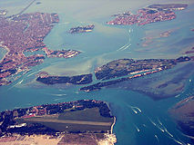 Part of the lagoon from the east. Vignole is in the centre, extending to the right. Venice is in the upper left.
 -
 St. Eurosia's church
 -
 Forte S Andrea


