Saint-Hilaire-le-Châtel | |
|---|---|
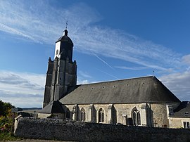
 The church in Saint-Hilaire-le-Châtel | |
| Coordinates: 48°33′56″N 0°31′55″E / 48.5656°N 0.5319°E | |
| Country | France |
| Region | Normandy |
| Department | Orne |
| Arrondissement | Mortagne-au-Perche |
| Canton | Mortagne-au-Perche |
| Intercommunality | Pays de Mortagne au Perche |
| Government | |
| • Mayor (2020–2026) | Philippe Blutel[1] |
| Area 1 | 22.34 km2 (8.63 sq mi) |
| Population (2021)[2] | 661 |
| • Density | 30/km2 (77/sq mi) |
| Time zone | UTC+01:00 (CET) |
| • Summer (DST) | UTC+02:00 (CEST) |
| INSEE/Postal code | 61404 /61400 |
| Elevation | 167–294 m (548–965 ft) (avg. 176 m or 577 ft) |
| 1 French Land Register data, which excludes lakes, ponds, glaciers > 1 km2 (0.386 sq mi or 247 acres) and river estuaries. | |
Saint-Hilaire-le-Châtel (French pronunciation: [sɛ̃.t‿ilɛʁ lə ʃatɛl] ) is a commune in the Orne department in north-western France.[3]
Points of interest[edit]
- Aérodrome de Mortagne-au-Perche is an Aerodrome within the commune which is also shared with neighbouring communes of Saint-Langis-lès-Mortagne that opened in 1978.[4][5] Its ICAO airport code is LFAX.[6] The airport has a 720 metre by 18 metre track that was created in 1985.[7]
See also[edit]
References[edit]
- ^ "Répertoire national des élus: les maires" (in French). data.gouv.fr, Plateforme ouverte des données publiques françaises. 13 September 2022.
- ^ "Populations légales 2021". The National Institute of Statistics and Economic Studies. 28 December 2023.
- ^ "Commune de Saint-Hilaire-le-Châtel (61404) − COG". www.insee.fr.
- ^ "L'aérodrome de Mortagne-au-Perche sera racheté par la Communauté de communes". actu.fr. 26 March 2021.
- ^ "Saint-Hilaire-le-Châtel · 61400, France". Saint-Hilaire-le-Châtel · 61400, France.
- ^ "Mortagne Au Perche - France". World Airport Codes.
- ^ "Il sera possible de découvrir toutes sortes d'avions aux portes ouvertes de l'aéroclub de Mortagne". Ouest-France.fr. 5 September 2023.


