The Guatemala portal
Republic of Guatemala República de Guatemala (Spanish) | |
|---|---|
Motto:
| |
| Anthem: Himno Nacional de Guatemala (English: "National Anthem of Guatemala") | |
| ISO 3166 code | GT |


Guatemala, officially the Republic of Guatemala, is a country in Central America. It is bordered to the north and west by Mexico, to the northeast by Belize, to the east by Honduras, and to the southeast by El Salvador. It is hydrologically bordered to the south by the Pacific Ocean and to the northeast by the Gulf of Honduras.
The territory of modern Guatemala hosted the core of the Maya civilization, which extended across Mesoamerica; in the 16th century, most of this was conquered by the Spanish and claimed as part of the viceroyalty of New Spain. Guatemala attained independence from Spain and Mexico in 1821. From 1823 to 1841, it was part of the Federal Republic of Central America.
For the latter half of the 19th century, Guatemala suffered instability and civil strife. From the early 20th century, it was ruled by a series of dictators backed by the United States. In 1944, authoritarian leader Jorge Ubico was overthrown by a pro-democratic military coup, initiating a decade-long revolution that led to social and economic reforms. In 1954, a US-backed military coup ended the revolution and installed a dictatorship.
From 1960 to 1996, Guatemala endured a bloody civil war fought between the US-backed government and leftist rebels, including genocidal massacres of the Maya population perpetrated by the Guatemalan military. The United Nations negotiated a peace accord, resulting in economic growth and successive democratic elections.
Guatemala's abundance of biologically significant and unique ecosystems includes many endemic species and contributes to Mesoamerica's designation as a biodiversity hotspot.
Although rich in export goods, around a quarter of the population (4.6 million) face food insecurity. Other extant major issues include poverty, crime, corruption, drug trafficking, and civil instability.
With an estimated population of around 17.6 million,0 Guatemala is the most populous country in Central America, the 4th most populous country in North America and the 11th most populous country in the Americas. Its capital and largest city, Guatemala City, is the most populous city in Central America. (Full article...)
Selected article -

The Maya civilization (/ˈmaɪə/) was a Mesoamerican civilization that existed from antiquity to the early modern period. It is known by its ancient temples and glyphs (script). The Maya script is the most sophisticated and highly developed writing system in the pre-Columbian Americas. The civilization is also noted for its art, architecture, mathematics, calendar, and astronomical system.
The Maya civilization developed in the Maya Region, an area that today comprises southeastern Mexico, all of Guatemala and Belize, and the western portions of Honduras and El Salvador. It includes the northern lowlands of the Yucatán Peninsula and the Guatemalan Highlands of the Sierra Madre, the Mexican state of Chiapas, southern Guatemala, El Salvador, and the southern lowlands of the Pacific littoral plain. Today, their descendants, known collectively as the Maya, number well over 6 million individuals, speak more than twenty-eight surviving Mayan languages, and reside in nearly the same area as their ancestors. (Full article...)Did you know (auto-generated)

- ... that the Adelaide L. T. Douglas House, built for a New York City socialite, housed the United States Olympic Committee before being sold to Guatemala?
- ... that the Central American government voted for annexation to the First Mexican Empire after a request from Regent Agustín de Iturbide?
Subcategories
WikiProjects

 Good article -

Mixco Viejo (/ˈmisko ˈβieχo/) ("Old Mixco"), occasionally spelt Mixcu Viejo, is an archaeological site in the north east of the Chimaltenango department of Guatemala, some 50 kilometres (31 mi) to the north of Guatemala City and 4 kilometres (2.5 mi) from the junction of the rivers Pixcaya and Motagua. It is a moderate sized ruined city of the Postclassic Maya civilization.
The archaeological site and tourist attraction of Mixco Viejo was named after being erroneously associated with the Postclassic Poqomam capital referred to in colonial records by that name. The archaeological site has now been identified as Jilotepeque Viejo, the capital of the Chajoma Kaqchikel kingdom. To distinguish between the two, the ruins of the Chajoma capital are now referred to as Mixco Viejo (Jilotepeque Viejo) while the former Poqomam capital is referred to as Mixco Viejo (Chinautla Viejo). (Full article...)Selected image -
-
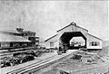 Station and Customs of Puerto Barrios, Guatemala, Northern Railway, 1896
 -
 A camioneta or chicken bus, a typical mode of transportation in Guatemala
 -

-
 A view of the beach in Livingston, Guatemala
 -
 Lake Atitlán, from a dock in San Juan La Laguna
 -
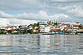 A view of Flores, El Petén
 -
 A low impact trail built for ecotourists to protect an archeological site in Guatemala
 -

-
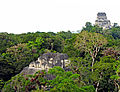 View from the top of the Lost World Pyramid, Temple IV on the right and top of pyramid 5C-49 (also known as the Talud-Tablero Temple) in the Plaza of the Lost World


More did you know -
- ... that Pascual Abaj, near Chichicastenango in Guatemala, is a sculpted stone idol that survived the Spanish conquest but was badly damaged in the 1950s by religious activists?
 Featured article -

The Spanish conquest of Petén was the last stage of the conquest of Guatemala, a prolonged conflict during the Spanish colonisation of the Americas. A wide lowland plain covered with dense rainforest, Petén contains a central drainage basin with a series of lakes and areas of savannah. It is crossed by several ranges of low karstic hills and rises to the south as it nears the Guatemalan Highlands. The conquest of Petén, a region now incorporated into the modern republic of Guatemala, climaxed in 1697 with the capture of Nojpetén, the island capital of the Itza kingdom, by Martín de Ursúa y Arizmendi. With the defeat of the Itza, the last independent and unconquered native kingdom in the Americas fell to European colonisers.
Sizeable Maya populations existed in Petén before the conquest, particularly around the central lakes and along the rivers. Petén was divided into different Maya polities engaged in a complex web of alliances and enmities. The most important groups around the central lakes were the Itza, the Yalain and the Kowoj. Other groups with territories in Petén included the Kejache, the Acala, the Lakandon Chʼol, the Xocmo, the Chinamita, the Icaiche and the Manche Chʼol. (Full article...)List of Featured articles
|
|---|
General images -
The following are images from various Guatemala-related articles on Wikipedia.
The time allocated for running scripts has expired.
The time allocated for running scripts has expired.
The time allocated for running scripts has expired.The time allocated for running scripts has expired.
The time allocated for running scripts has expired. The time allocated for running scripts has expired. The time allocated for running scripts has expired. The time allocated for running scripts has expired. The time allocated for running scripts has expired. The time allocated for running scripts has expired.
The time allocated for running scripts has expired.
The time allocated for running scripts has expired.
The time allocated for running scripts has expired. The time allocated for running scripts has expired.
Featured articles
Good articles
- 5to Piso
- 2010 Guatemala City sinkhole
- Adentro
- Gómez de Alvarado
- El Amor (Ricardo Arjona song)
- Francisco Javier Arana
- Jacobo Árbenz
- Ricardo Arjona
- La Blanca, Peten
- Bartolomé de las Casas
- Central America under Mexican rule
- Como Duele (Ricardo Arjona song)
- El Chal
- Fuiste Tú
- Guatemala at the 2016 Summer Paralympics
- Guatemalan Revolution
- Haʼ Kʼin Xook
- Independiente (Ricardo Arjona album)
- Itzam Kʼan Ahk II
- Iximche
- Kʼinich Yat Ahk II
- Kʼinich Yoʼnal Ahk I
- Manche Chʼol
- Marta (Ricardo Arjona song)
- Mi Novia Se Me Está Poniendo Vieja
- Mixco Viejo
- Motul de San José
- Mundo Perdido, Tikal
- North Acropolis, Tikal
- Poquita Ropa
- Puente (song)
- Quién Dijo Ayer
- Quién (Ricardo Arjona song)
- Quiero (Ricardo Arjona song)
- Battle of Roatán
- Simplemente Lo Mejor
- Spanish American wars of independence
- Spanish conquest of Yucatán
- Spanish conquest of the Maya
- Te Quiero (Ricardo Arjona song)
- Tikal
- Trópico (Ricardo Arjona album)
- Vida (Ricardo Arjona song)
- White-lipped peccary
- Yoʼnal Ahk III
- Zaculeu
Featured pictures
-
 Cinnamon hummingbird (Amazilia rutila) in flight Los Tarrales
 -
 Emerald swift (Sceloporus malachiticus) Finca El Pilar
 -
 Ocellated turkey (Meleagris ocellata) male Peten


The time allocated for running scripts has expired.
The following Wikimedia Foundation sister projects provide more on this subject:
-
 Commons
Free media repository -
 Wikibooks
Free textbooks and manuals -
 Wikidata
Free knowledge base -
 Wikinews
Free-content news -
 Wikiquote
Collection of quotations -
 Wikisource
Free-content library -
 Wikiversity
Free learning tools -
 Wikivoyage
Free travel guide -
 Wiktionary
Dictionary and thesaurus
The time allocated for running scripts has expired.
The current date and time in Guatemala is Friday, July 19, 2024, 06:08.
News media:
- The Guatemala Times
- La Prensa Libre (in Spanish)
- Wikinews Guatemala portal
The time allocated for running scripts has expired.
The time allocated for running scripts has expired.
-

-

-

-

-

-

-

-

-

-

-
 Random portal
 -


Purge server cache