Nizip | |
|---|---|
District and municipality | |
 | |
 Map showing Nizip District in Gaziantep Province | |
 Nizip Location in Turkey | |
| Coordinates: 37°00′36″N 37°47′50″E / 37.01000°N 37.79722°E | |
| Country | Turkey |
| Province | Gaziantep |
| Government | |
| • Mayor | Mehmet Sarı (AKP) |
| Area | 944 km2 (364 sq mi) |
| Population (2022)[1] | 148,386 |
| • Density | 160/km2 (410/sq mi) |
| Time zone | UTC+3 (TRT) |
| Postal code | 27700 |
| Area code | 0342 |
| Website | www |
Nizip (Medieval Greek: Nisibis or Nisibina; Ottoman Turkish: نزيب[2]) is a municipality and district of Gaziantep Province, Turkey.[3] Its area is 944 km2,[4] and its population is 148,386 (2022).[1]
It is located 45 km from the city of Gaziantep, 95 km from Şanlıurfa (Edessa), and 35 km from Karkamış.
Demographics
[edit]In early 20th century, the town housed 15,000 people and was mostly inhabited by Turks.[5]
Composition
[edit]There are 109 neighbourhoods in Nizip District:[6]
- Adaklı
- Akçakent
- Akkuyu
- Alahacı
- Altındağ
- Aşağıbayındır
- Aşağıçardak
- Atatürk
- Bağlıca
- Bahçeli
- Ballı
- Belkıs
- Boyluca
- Bozalioğlu
- Çakmaktepe
- Çanakçı
- Çatalca
- Cumhuriyet
- Dayıdağı
- Dazhüyük
- Dernek
- Doğrular
- Duraklı
- Dutlu
- Düzbayır
- Ekinci
- Erenköy
- Eskikonak
- Eyüp Sultan
- Fatih Sultan
- Fevkani
- Fevzipaşa
- Fırat
- Gaziler
- Gevence
- Gökçeli
- Güder
- Gülkaya
- Gümüşgün
- Günaltı
- Gürbaşak
- Güzelköy
- Hafızpaşa
- Hancağız
- Hazımoğlu
- İkizce
- İntepe
- İstasyon
- İstiklal
- Kale
- Kamışlı
- Karaburç
- Karşıyaka
- Kayalar
- Keklik
- Kesiktaş
- Kıbrıs
- Kıraçgülü
- Kıratlı
- Kızılcakent
- Kızılin
- Kocatepe
- Korucak
- Köseler
- Kumla
- Kurucahüyük
- Mağaracık
- Mehmetobası
- Menderes
- Mercanlı
- Mevlana
- Mihrap
- Mimarsinan
- Nahırtepe
- Namıkkemal
- Özyurt
- Pazarcami
- Saha
- Şahinbey
- Salkım
- Samandöken
- Samanlı
- Saray
- Sarıkoç
- Sekili
- Şıhlar
- Söğütlü
- Suboyu
- Sultan Abdulhamit
- Tahtani
- Tanır
- Tatlıcak
- Tosunlu
- Toydemir
- Tuluktaş
- Turlu
- Turnalı
- Uluyatır
- Yağcılar
- Yağmuralan
- Yarımtepe
- Yeniyapan
- Yeniyazı
- Yeşilevler
- Yolçatı
- Yukarıbayındır
- Yukarıçardak
- Yunus Emre
- Zeytinlik
Notable people
[edit]- Cahit Tanyol (1914–2020), Turkish sociologist
- Mehmet Ali Yaprak (1949–2004), Turkish businessman and drug trafficker
- Mustafa Cengiz (1949–2021), businessman who served as the president of sports club Galatasaray S.K.
- Mehmet Görmez (born 1959), former President of the Presidency of Religious Affairs and as such legally the highest level Islamic scholar in Turkey and the Turkish Republic of Northern Cyprus.
- Zihni Çakır (born 1969), journalist and author
- Ali Şahin (born 1970), Turkish politician who has been Deputy Minister of European Union Affairs since January 2016.
- Abdulhamit Gül (born 1977), Turkish politician
Gallery
[edit]-
 Nizip Town
 -
 Nizip Town view
 -
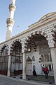 Nizip Mosque
 -
 Nizip Arched road
 -
 Nizip Architectural sight
 -
 Nizip Architectural detail
 -
 Nizip Fevkanı church
 -
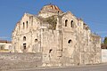 Nizip Fevkanı church
 -
 Nizip Fevkanı church


See also
[edit]References
[edit]- ^ a b "Address-based population registration system (ADNKS) results dated 31 December 2022, Favorite Reports" (XLS). TÜİK. Retrieved 12 July 2023.
- ^ Tahir Sezen Osmanlı Yer Adları (Alfabetik Sırayla), T.C. Başbakanlık Devlet Arşivleri Genel Müdürlüğü, Yayın Nu 21, Ankara, p. 385.
- ^ Büyükşehir İlçe Belediyesi, Turkey Civil Administration Departments Inventory. Retrieved 12 July 2023.
- ^ "İl ve İlçe Yüz ölçümleri". General Directorate of Mapping. Retrieved 12 July 2023.
- ^ Banse, Ewald (1923). Ewald Banse's Lexikon der Geographie L bis Z. G. Westermann. p. 198.
Nisib, nö Syrien, Stadt von 15000, meist türk E.
- ^ Mahalle, Turkey Civil Administration Departments Inventory. Retrieved 12 July 2023.
Nizip in Gaziantep Province of Turkey | |||||||||||||||||||||||||||
|---|---|---|---|---|---|---|---|---|---|---|---|---|---|---|---|---|---|---|---|---|---|---|---|---|---|---|---|
| Districts |   | ||||||||||||||||||||||||||
|
Metropolitan municipalities are bolded. | |||||||||||||||||||||||||||
| International | |
|---|---|
| National | |