Limours | |
|---|---|
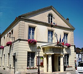
 The town hall in Limours | |
| Coordinates: 48°38′45″N 2°04′38″E / 48.6458°N 2.0771°E | |
| Country | France |
| Region | Île-de-France |
| Department | Essonne |
| Arrondissement | Palaiseau |
| Canton | Dourdan |
| Intercommunality | Pays de Limours |
| Government | |
| • Mayor (2020–2026) | Chantal Thiriet[1] |
| Area 1 | 14.25 km2 (5.50 sq mi) |
| Population (2021)[2] | 6,431 |
| • Density | 450/km2 (1,200/sq mi) |
| Time zone | UTC+01:00 (CET) |
| • Summer (DST) | UTC+02:00 (CEST) |
| INSEE/Postal code | 91338 /91470 |
| Elevation | 100–177 m (328–581 ft) |
| 1 French Land Register data, which excludes lakes, ponds, glaciers > 1 km2 (0.386 sq mi or 247 acres) and river estuaries. | |
Limours, often referred to as Limours-en-Hurepoix (French pronunciation: [limuʁ] ⓘ) is a commune the Essonne department in Île-de-France in northern France.
Geography[edit]
Limours is located 30 km (19 mi) from Paris.
Population[edit]
Inhabitants of Limours are known as Limouriens in French.
| Year | Pop. | ±% p.a. |
|---|---|---|
| 1968 | 2,264 | — |
| 1975 | 4,201 | +9.23% |
| 1982 | 4,774 | +1.84% |
| 1990 | 6,324 | +3.58% |
| 1999 | 6,465 | +0.25% |
| 2007 | 6,344 | −0.24% |
| 2012 | 6,560 | +0.67% |
| 2017 | 6,625 | +0.20% |
| Source: INSEE[3] | ||
Pays de Limours[edit]
Limours gives its name to, and is the most populated town of, the Communauté de communes du Pays de Limours, which aggregates fourteen Essonne communes. The administrative seat of the communauté, however, is in Briis-sous-Forges rather than Limours itself.[4]
List of Pays de Limours member towns:
- Angervilliers
- Boullay-les-Troux
- Briis-sous-Forges
- Courson-Monteloup
- Fontenay-lès-Briis
- Forges-les-Bains
- Gometz-la-Ville
- Janvry
- Les Molières
- Limours
- Pecqueuse
- Saint-Jean-de-Beauregard
- Saint-Maurice-Montcouronne
- Vaugrigneuse
See also[edit]
References[edit]
- ^ "Répertoire national des élus: les maires" (in French). data.gouv.fr, Plateforme ouverte des données publiques françaises. 13 September 2022.
- ^ "Populations légales 2021". The National Institute of Statistics and Economic Studies. 28 December 2023.
- ^ Population en historique depuis 1968, INSEE
- ^ CC du Pays de Limours (CCPL) (N° SIREN : 249100074), BANATIC
External links[edit]
 Media related to Limours at Wikimedia Commons
- Limours city council website (in French)
- Base Mérimée: Search for heritage in the commune, Ministère français de la Culture. (in French)
- Mayors of Essonne Association (in French)


