
Original file (1,275 × 1,650 pixels, file size: 332 KB, MIME type: application/pdf)
Summary
This image (or other media) is a work of an Environmental Protection Agency employee, taken or made as part of that person's official duties. As works of the U.S. federal government, all EPA images are in the public domain.
|
||
| Description |
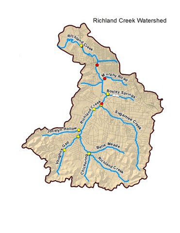
English: A map showing the boundary of Richland Creek Watershed (Nashville, Tennessee) with tributaries labelled. To be used in Wiki article Richland Creek (Nashville, Tennessee) |
| Date | |
| Source |
This is a map from Page 11 of a work (link below) mandated by the Environmental Protection Agency (EPA) of the US Government. The U.S. Congress mandated that all states develop a Source Water Assessment Program in the "1966 Safe Drinking Water Act". As such, the work is deemed a US Government document made by its "employee" (the local government) and is therefore non-copyrightable. See p. 64 of the link below for the consent decree mandating this and similar reports on water quality. The image is for use on the Wikipedia article Richland Creek (Nashville, Tennessee). A link to the report is given here: https://www.nashville.gov/Portals/0/SiteContent/WaterServices/Stormwater/docs/educational/Richland%20Creek%20Watershed%20Mngmt%20Plan%20draft_Final%20Draft.pdf |
| Author | Metropolitan Government of Nashville and Davidson County, prepared by Metro Water Services Stormwater Division |
Licensing
The document is not copyrightable for reasons of public policy. Works of the United States Government and various other governments are excluded from copyright law and may therefore be considered to be in the public domain in their respective countries.
File history
Click on a date/time to view the file as it appeared at that time.
| Date/Time | Thumbnail | Dimensions | User | Comment | |
|---|---|---|---|---|---|
| current | 02:01, 24 July 2019 |  | 1,275 × 1,650 (332 KB) | Eagledj | User created page with UploadWizard |