
Original file (7,716 × 5,565 pixels, file size: 7.27 MB, MIME type: image/jpeg)
Summary
| Description |
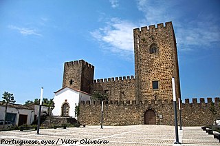
Castelo de planta rectangular com torres de ângulo, de secção quadrada, não maciças, interligadas pelos adarves dos troços de muralha; a Torre de São João, a sudeste, tem dois pisos, dispondo a de Menagem, a nordeste, de quatro (uma das janelas é mainelada, com moldura gótica). As quadrelas norte e sul apresentam escadas endossadas que dão acesso aos adarves; no centro do pátio, uma cisterna. O castelo está envolvido por barbacã de desenho pentagonal, com porta principal a nascente, envolvendo aí, a capela quinhentista de São João. É também neste sector que se abre a porta principal do castelo, junto à Torre de Menagem, localizando-se a da traição na diagonal oposta, através da qual se acede à liça e daí a exterior pela porta da barbacã, a sudoeste. Sítio e situação Situa-se em zona baixa, rodeado pelo casario, não desempenhando, já na altura em que foi construído, função estratégica de relevo. Tipologia militar Castelo com funções essencialmente residenciais para o Prior do Crato, do Período Gótico. Cronologia Sécs. XII-XIII – Amieira já teria fortificações; séc. XIV, meados – construção ou reconstrução pelo Prior D. Frei Álvaro Gonçalves Pereira; 1358/1359 – faziam-se “cauas & barbacas”; 1488 c. – prováveis obras de reparação; 1515 – Vasco Anes era vedor das obras; 1556 – construção da capela de São João; séc. XVII – construção de habitações no interior do castelo; 1724 – obras de beneficiação e recuperação (Torre de Menagem), 1846 – instalação do cemitério; obras de conservação e restauro nos anos de 1914 e de 1924; 1945 – início das intervenções da DGEMN; 2001 – início das intervenções do IPPAR. Eventos Bélicos 1440 – cerco e tomada do castelo pelas tropas do infante D. Pedro, comandadas por D. Álvaro Vaz de Almada, conde de Avranches. Domingos Bucho <a href="http://www.cm-nisa.pt/casteloamieira.html" rel="nofollow">www.cm-nisa.pt/casteloamieira.html</a> <a href="http://loc.alize.us/#/flickr:7205725220" rel="nofollow">See where this picture was taken.</a> <a href="https://www.flickr.com/groups/geotagging/discuss/72157594165549916/">[?]</a> |
| Date | |
| Source | Castelo de Amieira do Tejo - Portugal |
| Author | Vitor Oliveira from Torres Vedras, PORTUGAL |
| Camera location | | View this and other nearby images on: OpenStreetMap |
|---|
.jpg¶ms=039.508331_N_-007.815787_E_globe:Earth_type:camera_source:Flickr_&language=en)
Licensing
- You are free:
- to share – to copy, distribute and transmit the work
- to remix – to adapt the work
- Under the following conditions:
- attribution – You must give appropriate credit, provide a link to the license, and indicate if changes were made. You may do so in any reasonable manner, but not in any way that suggests the licensor endorses you or your use.
- share alike – If you remix, transform, or build upon the material, you must distribute your contributions under the same or compatible license as the original.
| This image was originally posted to Flickr by Portuguese_eyes at https://flickr.com/photos/21446942@N00/7205725220 (archive). It was reviewed on 15 April 2019 by FlickreviewR 2 and was confirmed to be licensed under the terms of the cc-by-sa-2.0. |
File history
Click on a date/time to view the file as it appeared at that time.
| Date/Time | Thumbnail | Dimensions | User | Comment | |
|---|---|---|---|---|---|
| current | 13:48, 22 May 2024 | | 7,716 × 5,565 (7.27 MB) | ReneeWrites | Removed watermark, perspective correction |
| 22:35, 15 April 2019 |  | 7,716 × 5,110 (6.49 MB) | Tm | Transferred from Flickr via #flickr2commons |
File usage
Global file usage
The following other wikis use this file:
- Usage on en.wikivoyage.org
- Usage on es.wikipedia.org
- Usage on gl.wikipedia.org
- Usage on pt.wikipedia.org
- Usage on www.wikidata.org
.jpg)