Size of this preview: 665 × 599 pixels. Other resolutions: 266 × 240 pixels | 533 × 480 pixels | 852 × 768 pixels | 1,136 × 1,024 pixels | 2,348 × 2,116 pixels.
Original file (2,348 × 2,116 pixels, file size: 5.43 MB, MIME type: image/jpeg)
Summary
| Description |
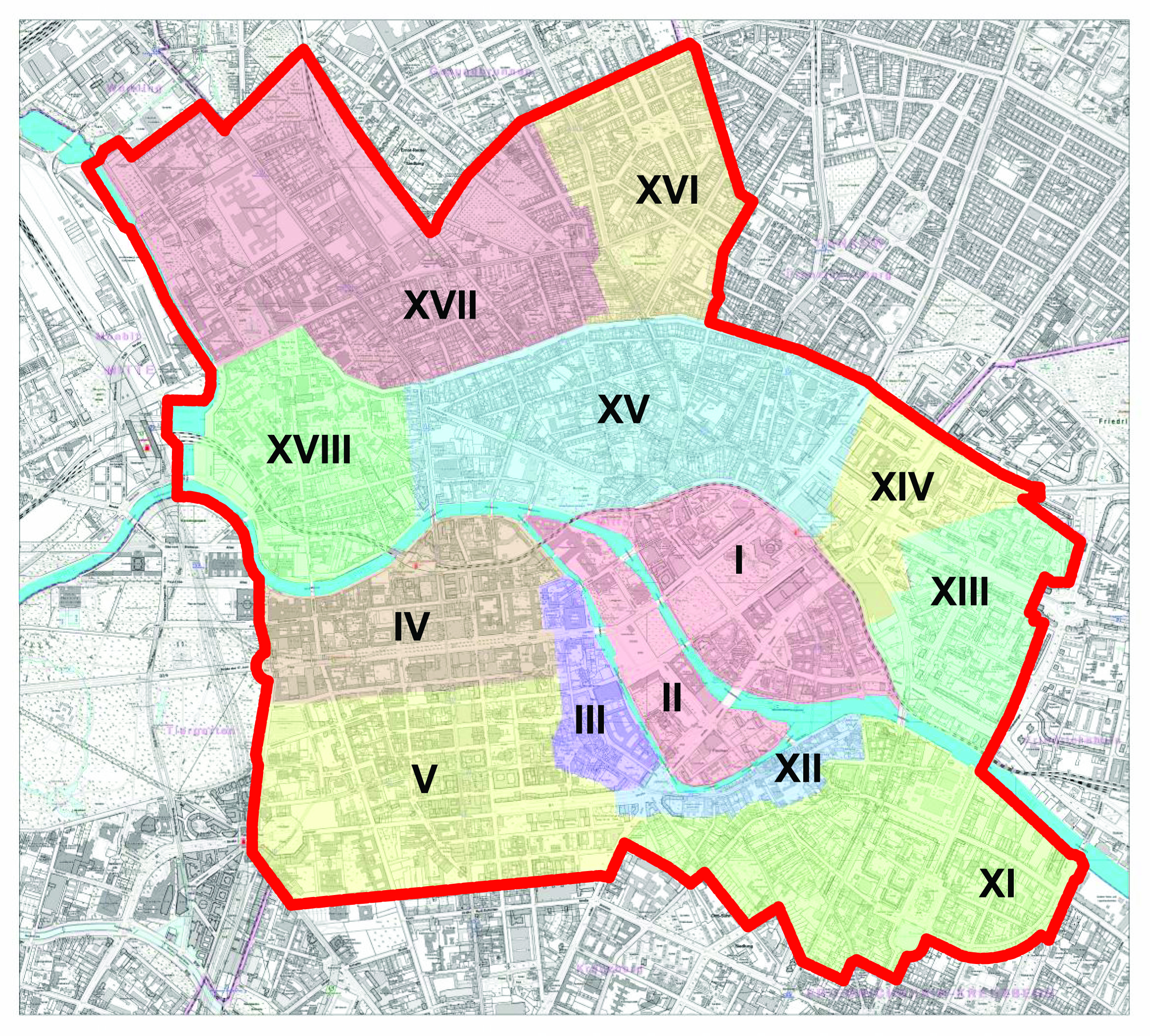
Deutsch: historische Stadtteile von Berlin (dargestellt nur innerhalb der rot eingezeichneten Grenze des heutigen Ortsteils Berlin-Mitte):
|
| Date | |
| Source |
Deutsch: Berlin-Mitte-Archiv |
| Author | Lutz Mauersberger (Berlin-Mitte-Archiv), Kartengrundlage: Geoportal Berlin / Karte von Berlin 1:5000 (K5 SW-Ausgabe) [1], Lizenz: Datenlizenz Deutschland – Namensnennung – Version 2.0 |
| Permission (Reusing this file) |
Licensing
This file is licensed under the Creative Commons Attribution-Share Alike 3.0 Unported license.
- You are free:
- to share – to copy, distribute and transmit the work
- to remix – to adapt the work
- Under the following conditions:
- attribution – You must give appropriate credit, provide a link to the license, and indicate if changes were made. You may do so in any reasonable manner, but not in any way that suggests the licensor endorses you or your use.
- share alike – If you remix, transform, or build upon the material, you must distribute your contributions under the same or compatible license as the original.
File history
Click on a date/time to view the file as it appeared at that time.
| Date/Time | Thumbnail | Dimensions | User | Comment | |
|---|---|---|---|---|---|
| current | 02:43, 10 September 2019 | | 2,348 × 2,116 (5.43 MB) | Lm-berlin | reduziert auf belegte historische Stadtteile |
| 11:47, 5 September 2019 |  | 2,346 × 2,119 (3.79 MB) | Lm-berlin | {{Information |Beschreibung = Berlin-Mitte, historische Stadtteile, Karte |Quelle = Berlin-Mitte-Archiv / Bezirksamt Mitte von Berlin (Kartengrundlage) |Urheber = Lutz Mauersberger |Datum = 05.09.2019 |Genehmigung = |Andere Versionen = |Anmerkungen = }} | |
| 11:42, 5 September 2019 |  | 3,508 × 2,480 (3.96 MB) | Lm-berlin | {{Information |Beschreibung = Berlin, historische Stadtteile - Karte |Quelle = Berlin-Mitte-Archiv / Bezirksamt Mitte von Berlin (Kartengundlage) |Urheber = Lutz Mauersberger |Datum = 05.09.2019 |Genehmigung = |Andere Versionen = |Anmerkungen = }} |
File usage
The following pages on the English Wikipedia use this file (pages on other projects are not listed):
Global file usage
The following other wikis use this file:
- Usage on de.wikipedia.org
- Alt-Kölln
- Berlin-Mitte
- Dorotheenstadt
- Friedrichstadt (Berlin)
- Oranienburger Vorstadt
- Luisenstadt
- Rosenthaler Vorstadt
- Spandauer Vorstadt
- Friedrich-Wilhelm-Stadt
- Alt-Berlin
- Neu-Kölln
- Stralauer Vorstadt
- Königsstadt
- Historische Mitte (Berlin)
- Liste der Kulturdenkmale in Berlin-Mitte
- Wikipedia Diskussion:WikiProjekt Listen der Kulturdenkmale in Berlin
- Liste der Kulturdenkmale in Berlin-Mitte/Rosenthaler Vorstadt
- Liste der Kulturdenkmale in Berlin-Mitte/Neu-Kölln
- Liste der Kulturdenkmale in Berlin-Mitte/Alt-Berlin
- Liste der Kulturdenkmale in Berlin-Mitte/Alt-Kölln
- Liste der Kulturdenkmale in Berlin-Mitte/Oranienburger Vorstadt
- Liste der Kulturdenkmale in Berlin-Mitte/Dorotheenstadt
- Liste der Kulturdenkmale in Berlin-Mitte/Friedrichstadt
- Liste der Kulturdenkmale in Berlin-Mitte/Friedrich-Wilhelm-Stadt
- Liste der Kulturdenkmale in Berlin-Mitte/Stralauer Vorstadt
- Liste der Kulturdenkmale in Berlin-Mitte/Luisenstadt
- Liste der Kulturdenkmale in Berlin-Mitte/Spandauer Vorstadt
- Liste der Kulturdenkmale in Berlin-Mitte/Königsstadt
- Liste der Kulturdenkmale in Berlin-Mitte/Friedrichswerder
- Vorlage:Navigationsleiste Kulturdenkmale in Berlin-Mitte
- Vorlage:Linkbox Historische Stadtteile in Berlin-Mitte
- Usage on sv.wikipedia.org