
Size of this preview: 800 × 485 pixels. Other resolutions: 320 × 194 pixels | 640 × 388 pixels | 1,024 × 621 pixels | 1,280 × 777 pixels | 2,560 × 1,553 pixels | 3,450 × 2,093 pixels.
Original file (3,450 × 2,093 pixels, file size: 5.66 MB, MIME type: image/jpeg)
Summary
| Description |
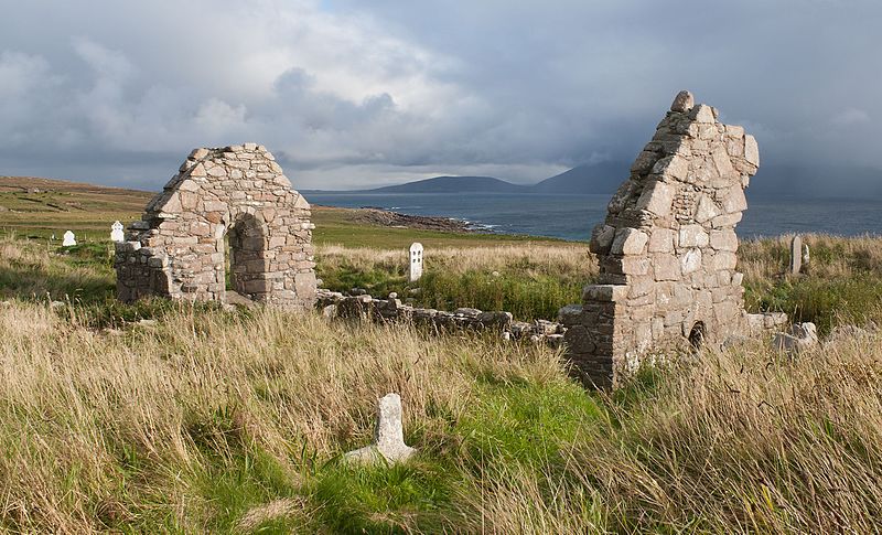
An Fál Mór, County Mayo, Ireland
English: North-west view of Teampall Deirbhile (St. Dervla's Church) in the evening sun with the Blacksod Bay and Achill Island in the background. |
||
| Date | |||
| Source | Self-photographed | ||
| Author | Andreas F. Borchert | ||
| Reference | 2013/23205 |

|
|
Do not upload new revisions over this file version without my explicit consent. Instead, use the possibility to upload a new version under a new name and tag it as a derivative or extract of this file.
|

Licensing
Andreas F. Borchert, the copyright holder of this work, hereby publishes it under the following licenses:
This file is licensed under the Creative Commons Attribution-Share Alike 3.0 Germany license.
Attribution: Andreas F. Borchert
- You are free:
- to share – to copy, distribute and transmit the work
- to remix – to adapt the work
- Under the following conditions:
- attribution – You must give appropriate credit, provide a link to the license, and indicate if changes were made. You may do so in any reasonable manner, but not in any way that suggests the licensor endorses you or your use.
- share alike – If you remix, transform, or build upon the material, you must distribute your contributions under the same or compatible license as the original.

This file is licensed under the Creative Commons Attribution-Share Alike Attribution-Share Alike 4.0 International, 3.0 Unported, 2.5 Generic, 2.0 Generic and 1.0 Generic license.
Attribution: Andreas F. Borchert
- You are free:
- to share – to copy, distribute and transmit the work
- to remix – to adapt the work
- Under the following conditions:
- attribution – You must give appropriate credit, provide a link to the license, and indicate if changes were made. You may do so in any reasonable manner, but not in any way that suggests the licensor endorses you or your use.
- share alike – If you remix, transform, or build upon the material, you must distribute your contributions under the same or compatible license as the original.

|
Permission is granted to copy, distribute and/or modify this document under the terms of the GNU Free Documentation License, Version 1.2 or any later version published by the Free Software Foundation; with no Invariant Sections, no Front-Cover Texts, and no Back-Cover Texts. A copy of the license is included in the section entitled GNU Free Documentation License. |
You may select the license of your choice.
This image has been assessed using the Quality image guidelines and is considered a Quality image.
|
| Camera location | | View this and other nearby images on: OpenStreetMap |
|---|
File history
Click on a date/time to view the file as it appeared at that time.
| Date/Time | Thumbnail | Dimensions | User | Comment | |
|---|---|---|---|---|---|
| current | 06:18, 15 June 2014 | | 3,450 × 2,093 (5.66 MB) | AFBorchert | {{User:AFBorchert/Photo |Location=An Fál Mór, County Mayo, Ireland |Date=2013-09-09 |Description={{en|North-west view of Teampall Deirbhile (St. Dervla's Church) in the evening sun with the Blacksod Bay and Achill Island in the background.}} |Referen... |
File usage
The following pages on the English Wikipedia use this file (pages on other projects are not listed):
Global file usage
The following other wikis use this file:
- Usage on de.wikipedia.org
- Usage on es.wikipedia.org
- Usage on nn.wikipedia.org
- Usage on www.wikidata.org