| 2015 Oregon wildfires | |
|---|---|
 Air tanker dropping fire retardant on a wildfire in Central Oregon | |
| Statistics[1] | |
| Total fires | 2,588 |
| Total area | 685,809 acres (2,775.37 km2) |
The 2015 Oregon wildfires were an ongoing series of wildfires affecting parts of the U.S. state of Oregon.
August fire[edit]
The August fire was reported on August 22, 2015, 10 miles (16 km) east of Banks. It was fully contained by August 24. It was suspected to be human-caused. One firefighter was injured. Three aircraft were used, taking water from Henry Hagg Lake, which led to its closure for recreational purposes. An estimated 26 acres (11 ha) were part of the burn, and 60 firefighters were needed. Highway 26 was closed for several days.[2][3]
Cornet-Windy Ridge fire[edit]
The Cornet-Windy Ridge fire has burned more than 103,800 acres (42,000 ha) on public forest and private lands a few miles west of Durkee. As of August 23, 2015, the fire was 80 percent contained.[4]
Eldorado fire[edit]
The Eldorado fire, which was caused by lightning, has burned more than 20,600 acres (8,300 ha) of land 5 miles (8.0 km) southeast of Unity. As of August 23, 2015, the fire was 65 percent contained.[4]
Stouts fire[edit]
The human-caused Stouts fire has burned 26,000 acres 16 miles (26 km) east of Canvyonville, just south of Milo. As of August 23, 2015, the wildfire was 83 percent contained.[4]
Willamina Creek fire[edit]
The Willamina Creek fire, occurring 9 miles (14 km) north of Willamina, has burned 230 acres (93 ha) in "heavy fuels on high-value timberland owned by the Bureau of Land Management and private industrial forestland owners". As of August 23, 2015, the fire was 20 percent contained.[4]
Smoke in the Willamette Valley[edit]
Wildfire smoke from Washington and Oregon was blown west over western Oregon, including Portland and the rest of the Willamette Valley, on August 22–23, 2015.[5][6]
-
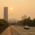 Portland skyline during 2015 Oregon wildfires - seen are the U.S. Bancorp Tower and White Stag sign from the Burnside Bridge
 -
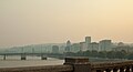 Portland skyline and the Burnside Bridge
 -
 Portland skyline from Mt. Tabor at sunset


See also[edit]
References[edit]
- ^ "National Report of Wildland Fires and Acres Burned by State 2015" (PDF). National Interagency Fire Center. Archived from the original (PDF) on 28 June 2018. Retrieved 31 August 2016.
- ^ "Brush fire that closed U.S. 26 caused by person, authorities say". OregonLive.com. Retrieved 24 August 2015.
- ^ "August Fire contained, but U.S. 26 road closure continues (photos)". OregonLive.com. Retrieved 24 August 2015.
- ^ a b c d Alteir, Nuran (August 23, 2015). "Northwest wildfires: Crews make progress on some blazes while containment stagnates elsewhere". The Oregonian. Retrieved August 24, 2015.
- ^ Denson, Bryan (August 22, 2015). "Wind blows wildfire smoke over Cascades into Portland area, triggering unhealthy readings in Beaverton, Government Camp". The Oregonian. Retrieved December 2, 2015.
- ^ "Air Quality Slips To 'Unhealthy' Levels Due To Wildfire Smoke". OPB News. Oregon Public Broadcasting. August 22, 2015. Retrieved December 2, 2015.