m rv test edits |
128.83.69.15 (talk) Climate data added |
||
| Line 36: | Line 36: | ||
== Geography == |
== Geography == |
||
Kharagpur is located at {{Coord|22.330239|N|87.323653|E|}}.<ref>[http://www.fallingrain.com/world/IN/28/Kharagpur.html Falling Rain Genomics, Inc - Kharagpur]</ref> It has an average elevation of 29 metres (95 ft). |
Kharagpur is located at {{Coord|22.330239|N|87.323653|E|}}.<ref>[http://www.fallingrain.com/world/IN/28/Kharagpur.html Falling Rain Genomics, Inc - Kharagpur]</ref> It has an average elevation of 29 metres (95 ft). |
||
== Climate == |
|||
{{climate chart |
|||
|[[Kharagpur]] |
|||
|14|27|19 |
|||
|18|30|41 |
|||
|22|33|38 |
|||
|24|35|46 |
|||
|26|36|148 |
|||
|26|34|277 |
|||
|26|32|278 |
|||
|26|32|301 |
|||
|25|32|284 |
|||
|23|32|162 |
|||
|19|30|31 |
|||
|15|27|11 |
|||
|source=[http://www.myweather2.com/City-Town/India/Kharagpur/climate-profile.aspx myweather2] |
|||
|float=left |
|||
|clear=none |
|||
}} |
|||
Kharagpur has a tropical wet and dry climate. Summers start in March and are hot and humid, with average temperatures close to 30 C (86 F). They are followed by the monsoon season that sees about 1140 mm (45 inches) of rain. Winters are mild and brief, lasting from December to mid February, with average temperatures around 22 C (72 F). Total annual rainfall is around 1400mm (55 in). |
|||
== History == |
== History == |
||
Revision as of 18:33, 12 March 2012
Kharagpur
Kharagpur | |
|---|---|
Town | |
| Government | |
| • Chairman of the Municipality | Jaharlal Pal (T.M.C) |
| Population (2011) | |
| • Total | 293,719 |
| Website | paschimmedinipur.gov.in/ |
Kharagpur (KGP) (Bengali: খড়্গপুর) is an industrial city in India. It is located in the Midnapore West district of the state of West Bengal.
Kharagpur was chosen as the location of the first campus of the prestigious Indian Institutes of Technology (IITs). The IITs are the premier technical education institutes in India and are internationally recognised for their academic and technical excellence. Unlike other IITs, IIT Kharagpur has been long known for its ability to offer unusual courses not offered in other IITs. The campus is located in Hijli.
Kharagpur also has one of the biggest railway workshops in India with the longest railway platform in the world [1072.5 m].[1] Kharagpur has the first underground Air Force station in Kalaikunda and it also has one more Air Force station in Salua.
Location
Kharagpur,the fourth largest city of West Bengal in area, lies on the latitude of 22 02’ 30” & longitude 87 11’ 0”, covering an area of about 30 km² located in the south-west part of Midnapore. This sub-division town is formed with Dalma Pahar and alluvial tract of Midnapore. It is intersected by numerous waterways, the important rivers being Subarnarekha, Keleghai and Kangsabati.
Geography
Kharagpur is located at 22°19′49″N 87°19′25″E / 22.330239°N 87.323653°E.[2] It has an average elevation of 29 metres (95 ft).
Climate
| Kharagpur | ||||||||||||||||||||||||||||||||||||||||||||||||||||||||||||
|---|---|---|---|---|---|---|---|---|---|---|---|---|---|---|---|---|---|---|---|---|---|---|---|---|---|---|---|---|---|---|---|---|---|---|---|---|---|---|---|---|---|---|---|---|---|---|---|---|---|---|---|---|---|---|---|---|---|---|---|---|
| Climate chart (explanation) | ||||||||||||||||||||||||||||||||||||||||||||||||||||||||||||
| ||||||||||||||||||||||||||||||||||||||||||||||||||||||||||||
| ||||||||||||||||||||||||||||||||||||||||||||||||||||||||||||
Kharagpur has a tropical wet and dry climate. Summers start in March and are hot and humid, with average temperatures close to 30 C (86 F). They are followed by the monsoon season that sees about 1140 mm (45 inches) of rain. Winters are mild and brief, lasting from December to mid February, with average temperatures around 22 C (72 F). Total annual rainfall is around 1400mm (55 in).
History
Historically, Kharagpur was a part of Hijli Kingdom and ruled by Hindu Oriya rulers as a feudatory under Gajapati Kings of Orissa. Historians claim that in the 16th century, Kharagpur was still a small village surrounded by dense forests. The village was on high rocky barren land. The only inhabited settlement near Kharagpur was Hijli. Hijli was a small island village on the banks of River Rasulpur in the delta of Bay of Bengal. It developed into a Port town in 1687. Hijli was also a Province and was in existence till 1886. It covered parts of Bengal and Orissa. It had important towns like Tamluk, Panskura, Debra along with Kelghai & Haldi rivers on the North, the South and East sides bounded by Bay of Bengal and Kharagpur, Keshiary, Dantan and Jaleswar on the West.
Hijli was ruled by Taj Khan who was the disciple of Guru Peer Mackdram Sha Chisti. It was also ruled by Kushan, Gupta and Pal dynasties, and by the Mughals. It is said that Hijli had excellent business and trade centers with judiciary, jail and administrative offices during the reign of Hindu Kings and during the Moghul Raj. Hijli Province was at its peak in 1754 AD and was highly prosperous during this period. The capital of Hijli was in Bahiri up to 1628 A.D. and was shifted to Hijli afterwards.
In the 18th century another Port town Khejuri came into existence, primarily set up by the British for carrying out trade with European countries. Khejuri was also an island set up on the banks of River Koukhali in the delta region. Development of this region because of Khejuri and Hiji Port can be gauged by the fact that the first Indian Telegraph Office was established in 1852 connecting Khejuri with Calcutta. In the devastating cyclone of 1864, both the ports got destroyed. The islands have since got merged with the mainland.
Captain Nicolson was the first English colonialist to invade Hijli and captured the Port. In 1687 Job Charnock with 400 soldiers and warships captured Hijli defeating Hindu & Mughul defenders. After the war with the Mughals, a treaty was signed between Job Charnock and the Mughul Emperor. The loss suffered by Job Charnock forced him to leave Hijli and proceed towards Uluberia while the Mughul Emperor continued to rule the Province. From there they finally settled at Sutanuti in Kolkata for establishing their business in Eastern India. This was the start of East India Company in India. Hijli as we know it today, is only a very small part of erstwhile Hijli Province and was created for establishing administrative offices by the British in the 19th century. It is curious that almost the entire Kharagpur division of today has boundaries identical to Hijli Province.
The name of Kharagpur derived from the name of old Shiva temple called ‘Khargeswar’ located at the outskirts of Kharagpur. The Temple was established by King Kharag Singh Pal and was named after him. The place of Kharagpur has mythological importance too. As depicted in Mahabharata, this area was ruled by the Demon King Hiramba. Pancha Pandavas spent a part of their repatriation years here. Bhim had fallen in love with Hirimba, sister of Hiramba. This annoyed Hiramba who clashed with Bhim. Hiramba was killed by Bhim at the same place where Khargeswar Temple is located.
Demographics
In the 2011 census, Kharagpur Urban Agglomeration had a population of 293,719, out of which 150,487 were males and 143,232 were females. The 0–6 years population was 25,130. Effective literacy rate for the 7+ population was 85.61.[3]
As of 2001[update] India census,[4] Kharagpur had a population of 207,984 (municipalty area) and 88,339 (railway sattlement area), the second largest in West Bengal. Males constitute 52% of the population and females 48%. Kharagpur has an average literacy rate of 64%, higher than the national average of 59.5%: male literacy is 75%, and female literacy is 52%. In Kharagpur, 10% of the population is under 6 years of age. Kharagpur acquires its unique place in India as a town of mixed ethnicity and linguistic diversity. At present Kharagpur City has a population almost 6.5 lakhs.And including the population of railways,IIT army,AirForce,EFR & the rest of common populations,it builds upto 14.5 lakhs.
Transport
Railways
The first Railway establishment at Kharagpur started with the commissioning of the rail link between Cuttack – Balasore – Kharagpur and from Sini to Kolaghat via Kharagpur. Kharagpur as a junction station was established in Railway map in December 1898. The public mood and the reaction of society on introduction of rail transport in this region has been nicely depicted by the famous Bengali Novelist Dr Ramapada Choudhury who was born and brought up in Kharagpur, in his Bengali novel Prothom Prohor. It is said that the people were initially afraid to travel by train for the fear of accident over the bridge (fear of collapsing of bridge), fear of getting outcaste status since there were no separate seating arrangement for different castes and religions. However, things changed due to famines in the early 20th century. The Railway Company came forward and offered jobs to the local unemployed men, gave them free ride by train and even offered a blanket for traveling by train. This promotional scheme broke the taboos and made rail transport acceptable to the society.
Midnapur, the District Headquarters was connected (up to the bank of Kosai river) in February 1900. Construction of the bridge over Kosai completed in June 1901. The rail line from Howrah to Kolaghat up to the Eastern bank and from Kharagpur up to Western bank of Rupnarayan River was completed in 1899. However through trains between Howrah and Kharagpur could only be possible in April 1900 after the bridge over Rupnarayan river was completed.
Howrah – Amta light Railway (2 ft gauge - 610 mm ) line was completed in 1898 and was operated by M/s Martin & Co. of Calcutta. This link remained operative till 1971. After closure of the light Railways, demand for a broad gauge line between Howrah and Amta gained momentum. The project got completed in four phases. In the first phase, the line between Santragachi and Domjur was completed in 1984. In the 2nd phase under Project Unigauge it got extended up to Bargachia in 1985. Extension up to Mushirhat (Mahendralal Nagar station) was completed in 2000 and the final lap up to Amta got completed in December 2004.
The need for rail link between Panskura and Tamluk was conceived at the beginning of 20th century, almost at the same time when the rail link between Howrah and Kharagpur was opened. Railway company received offers for construction from two Agencies, M/S Martin & Company and M/s Babu Nibaran Chandra Dutta. The former against guaranteed return of 3.5% while the latter without any guarantee. Although the offer of the latter was lucrative, the dilemma of whether to offer the work of construction to a native or not forced the project to be abandoned. After Independence, the requirement of rail link connecting Panskura and Durgachak came up primarily for the purpose of constructing Haldia Port. The rail link between Panskura – Durgachak via Tamluk completed in 1968, which was later on extended to Haldia in 1975. Extension of rail link to Digha from Tamluk was sanctioned in 1984 and it took 20 years to complete this project in two phases, the first phase of linking Tamluk and Contai completed in November 2003 and the tourist destination Digha got connected to Howrah/Shalimar in December 2004.
Geographical location of Kharagpur and its rail links with the rest of the Country favoured construction of a centralized Workshop with facilities to carry out major repairs of all broad gauge stock. In 1900 the work was sanctioned and the construction of the Workshop completed in 1904.
Road Transport
Kharagpur also well connected with various places by road.There are many buses is going to different places from kharagpur central bustand which is situated beside Kharagpur railway station.Different routes are Kharagpur-Digha,Kharagpur-Tata,Kharagpur-Dhumsai,Kharagpur-Gopiballavpur,Kharagpur-Kolkata,Kharagpur-Haldia,Kharagpur-Siliguri,Kharagpur-Bankura,Kharagpur-Asansol,Kharagpur-Baripada,Kharagpur-Keshiyari etc.So many local mini bus is providing services between Kharagpur-Midnapore.Town itself is connected with various local places by Auto.Auto become the heart of the transport.The timing of Auto service mainly between 4.30 am to 9.30 pm.Taxi,Car,Rikshaw are also available.
Internet & Telecom Services
Internet service has improved many folds compared to last 5 yrs. BSNL is the sole government sourced provider and the local hub is in Kharagpur. Broadband and dial up service is available to the public. Possession of PCs is becoming very common at homes and many business firms,so usage of Internet has also gained a high peak. Plug-to-surf services are also being provided by some of the operators such as BSNL,TATA,RELIANCE etc.The Internet services are expected to improve more in the coming yrs with more high speed and availability of broadband services by the private operators. There are so many landphone and mobile phone operator in this town.Currently Airtel,Vodafone,BSNL,Reliance (GSM & CDMA),MTS,Virgin,Idea,Tata Docomo,Tata Indicom,Aircel,Uninor are providing their services.
Schools in Kharagpur
Some schools in Kharagpur are:
- Nimpura Aryya Bidyapith(school captain: Raunak sk)
- Siddheswari High School,Arambati
- Janta Vidyalya ward no -16
- Hitkarini High Secondary School
- Kharagpur Atulmoni Polytechnic High (H.S.) School
- Sacred Heart High School
- Kendriya Vidyalaya No.2, Kharagpur
- Kendriya Vidyalaya No.2, Kalaikunda
- Kendriya Vidyalaya No.1, Kalaikunda
- Kendriya Vidyalaya, IIT Kharagpur
- Kendriya Vidyalaya, Salua
- St. Agnes High School
- S E Rly Higher Secondary School (English Medium)
- S E Rly Boys Higher Secondary School, Near Gole Bazar
- S E Rly Girls Higher Secondary School, Near Gole Bazar
- S E Rly High School, New Settlement
- S E Rly Mixed Primary School, Near Bus Stand
- Splendour high school, Salua
- DAV Model School,IIT
- Christophers Day School, Malancha
- Kharagpur Silver Jubilee High School
- Hijli High School,IIT KGP
- Inda valika Vidyalaya
- Inda Krishnalal Siksha Niketan
- South Side Girls High School
- South Side High School
- South Side Model School
- Andhra Higher Secondary School, New Settlement
- Utkal Vidyapitha, Giri Maidan
- St. Josephs High School, Old Settlement
- Ward Memorial Church School, Kharida
- Balarampur Abhoy Ashram Naitalim Vidyapith, Balarampur
- Janakalyan Boys & Girls Higher Secondary School, Subhaspally
- Telugu Vidhya Peetham
- Chhattisgarh High school,Ayma,
- Siddharth primary school, Chhotta ayma,
- Bharat primary school, ayma,
- Kharagpur Traffic High School, Traffic Settlement.
- Priyanath Roy High School, Malancha
Hospital
The need for a centralized Hospital at Khargpur was also felt in late 19th century and the Hospital with complete medical facilities was established in 1897. Dr Arthur Martin Leake, Victorian Cross winner was appointed as Chief Medical Officer of Kharagpur Hospital in 1904.
On 16 September 1931, freedom fighters in Hijli Jail celebrated the killing of Sessions Judge Mr Garley, who had passed death penalty to famous Freedom fighter Shri Dinesh Gupta. The Jail authorities could not tolerate this and killed the freedom fighters in their cell. Today the infamous Hijli Jail is located inside the IIT campus area. Now the name of Kharagpur is synonymous with IIT. The railway establishment bears testimony of its (IIT Kharagpur’s) development in the initial years. The Father of Nation Mahatma Gandhi served his term in the Hijli Jail as did Khudiram Bose, an eminent Freedom fighter of Bengal.
Today Railway Main Hospital and Kharagpur Sub-divisional Hospital (Chandmari Hospital)are main public sector hospitals in Kharagpur.A number of private clinics and nursing homes also operate. However, overall quality of health care facilities is at best modest and people mostly go to Midnapur or Kolkata for better health care.
Kharagpur Today
Kharagpur is a place where people from every religion and caste from all over the country reside. Kharagpur still retains its small-town charm. However night life in Kharagpur and its suburbs are gradually developing with the mushrooming of various Malls and Hotels. Kharagpur is also developing in the field of Real estate there are lots of Projects going on such as housing complex like The Regent Heritage, Diamond Tower I, II, III, IV ,V and VI. There is also a real estate called The Atwals Real Estate where many Banks are given place in rent to carry on their business. There is also a new Big Bazar opened in Kharagpur and a shopping complex is going to be opened by The Regent Heritage as a part of its Project. Kharagpur is fast developing as an industrial township with several existing and new industries coming up. The major industries present in Kharagpur are:
Existing Industrial Units:
- Bansal Cement Private Limited (Grinding Unit)
- Telecom Factory(taken over by BSNL since 2000)
- Aso Cement Ltd. (Slag Cement)
- Essen Fabricators Private Limited (Heavy Engineering Division)
- Siemens Pvt Ltd (Industrial Gears)
- Humboldt Wedag (I) Ltd. (Slurry Pumps)
- SE Railway Workshop (Carriage, Wagon, Steel and Diesel Locomotive Maintenance)
- Tata Bearings Ltd. (Bearings and its Castings)
- Tata Constructions & Projects Limited formerly Tata Davy Ltd. (Heavy Engineering) (This factory has been closed since 2003)
- Bengal Energy Limited (Pig & Sponge Iron)
- Tata Metaliks Ltd. (Pig Iron Plant)
- Kalimati Steel Pvt. Ltd. (Manufacturers and Processors of Low Ash Metallurgical Coke)
- Wellman Wacoma Ltd. (Coke Oven/Metallurgical Coke)
- Rashmi Metaliks (PIG Iron Manufacturing Unit)
- Ramswarup Lohh Udyog(Finished Steel)
- Sai Fertilizer Pvt Ltd (SSP manufacturer)
- KE Technical Textiles Pvt. Ltd. (Technical Textiles, Gauntlets, Fiber Glass Fabric)
- TELCON off the road vehicle plant.
- Avtec Limited
- Century Extrusions Ltd.
- Tata Kubata
Upcoming Major Units:
- Aso Cement Ltd. (Cement (expansion))
- Century Iron & Steel
- Mittal Ferro Cast Pvt. Ltd
Development in the area is stimulated by the presence of the IIT campus, the proximity to Kolkata and the excellent rail connections.
There are marketplaces called Gole bazar, Puratan Bazar and Gate Bazar, a super market at co-operative Golebazar and one at Malancha. The place Subhaspally is a good place to live with Padmapukur on the north side. The BNR ground is a very large playground which can be developed and properly maintained.
Kharagpur has more stations on it like "Giri Maidan","Hijli","Nimpura","Kalaikunda" etc. "Hijli" is going to be second important railway station in Kharagpur City. Kharagpur-Howrah sub-urban Local Trains will start from "Hijli" soon and also Delhi going expresses and some more express trains will be stopped here in "Hijli" very soon.
There are several railway residential areas namely Chhotta Ayma, Bara Ayma, Old Settlement, New Settlement, Mathurakati, Nimpura, South Side, Traffic etc., One of the major development in the town is grand opening of multi retail 'Puja Complex' near famous Jaganath mandir with major stores like Big Bazaar, Pantaloons and many more. Recently the city witnessed another gala opening of a Shopping Mall named "Regent Station" in Malancha Road.
Movie theaters include "Bombay Talkies","Aurora","Shitala","South Cinema" etc. Bombay Cimema is now equipped with digital projection and surround sound system. But the conditions other movie halls are pathetic. Also the good news is that the famous multiplex "INOX" is going to be opened at "Puja Complex" very soon.
Places of worship include a "Durga Mandir" at Gole Bazar,"Church" at Golebazar,"Gurudwara" at Subhaspally and one at Nimpura, "Masjid" near Gole Bazar, and several temples and churches. "Jagannath Mandir" near Gate Bazar is the newest temple in the City.
Nimpura is a place for housing of thousands of Railway Employees. From Nimpura a Railway shuttle called Kooli Gari ran till Gate Bazar.
There is an long winding road from Nimpura to Hijli which goes through TangraHut (Arambati), Talbagicha and another one from Kalaikunda to Gopali through Hiradihi,Talbagicha.
The South Side of Kharagpur is a planned area belonging to the Indian Railways which was established by Britishers as residential area. Nearby is The Kharagpur Municipality and the fire station. It also contains famous Telugu schools like Andhra High School and Telugu Vidya Peetham.
The most famous festivals here are Durga Puja, Ganesh Puja, Saraswati Puja, Kali Puja and Ammavaari puja etc., Also Raas, and Mata Puja is conducted in a year by locals in the whole railway colony. Rath Mela celebrated near the premises of Jagannath Temple. But the Biggest festival of all is the "Dashera" or "Ravan Pora"(in local term).
Kharagpur also have its own bookfair called "Kharagpur-er Boimela" in Bengali,which started from 2000 and happen in January every year. A Flower Fair ("Ful Mela" in bengali) is also organised every year..
Administration and governance
Kharagpur Municipality looks after civic affairs in the town. There is a proposal to upgrade it to a Municipal Corporation after including railway area under its jurisdiction. As of now responsibility of civic amenities in railway area lies with the Divisonal Railway Manager, Kharagpur Division who is also the head of railway establishment in Kharagpur.
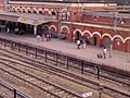
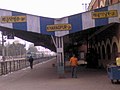
Gallery of the Railway Station
-
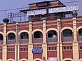 Outside view of the station
 -
 The Rajdhani Express halted at the station
 -
 The Coromandel Express halted at the station
 -
 An aerial view the station
 -
 The station
 -
 The station


References
- ^ [1]
- ^ Falling Rain Genomics, Inc - Kharagpur
- ^ "Urban Agglomerations/Cities having population 1 lakh and above" (PDF). Provisional Population Totals, Census of India 2011. Retrieved 2011-10-21.
- ^ Template:GR
External links
- Indian Institute of Technology, Kharagpur
- Kharagpur Silver Jubilee High School
- IIT
- KGP Railway
- Kharagpur’s diaspora reunited
- Noticeboard of Medinipur
- JantaReview Kharagpur Page
