Villetelle | |
|---|---|
 Square. In the background on the left: the town hall, on its right the Saint Géraud church. | |
 Coat of arms | |
Location of Villetelle  | |
 Villetelle  Villetelle | |
| Coordinates: 43°44′05″N 4°08′26″E / 43.7347°N 4.1406°E | |
| Country | France |
| Region | Occitania |
| Department | Hérault |
| Arrondissement | Montpellier |
| Canton | Lunel |
| Government | |
| • Mayor (2020–2026) | Jean-Pierre Navas[1] |
| Area 1 | 5.31 km2 (2.05 sq mi) |
| Population (2021)[2] | 1,628 |
| • Density | 310/km2 (790/sq mi) |
| Time zone | UTC+01:00 (CET) |
| • Summer (DST) | UTC+02:00 (CEST) |
| INSEE/Postal code | 34340 /34400 |
| Elevation | 10–67 m (33–220 ft) (avg. 37 m or 121 ft) |
| 1 French Land Register data, which excludes lakes, ponds, glaciers > 1 km2 (0.386 sq mi or 247 acres) and river estuaries. | |
Villetelle (French pronunciation: [viltɛl]; Occitan: Vilatèla) is a commune in the Hérault department in the Occitanie region in southern France.
Geography[edit]
The river Vidourle, which is the boundary between the departments of Gard and Hérault, runs along the town.
History[edit]

The Gallo-Roman archaeological site of Ambrussum is located there.
Education[edit]
Administration[edit]
| Election | Mayor | Party | Occupation | |
|---|---|---|---|---|
| 2001 | Jean-Pierre Navas | DVG | Retiree | |
Population[edit]
| Year | Pop. | ±% p.a. |
|---|---|---|
| 1968 | 154 | — |
| 1975 | 194 | +3.35% |
| 1982 | 248 | +3.57% |
| 1990 | 507 | +9.35% |
| 1999 | 923 | +6.88% |
| 2009 | 1,378 | +4.09% |
| 2014 | 1,463 | +1.20% |
| 2020 | 1,558 | +1.05% |
| Source: INSEE[3] | ||
Pictures[edit]
-
 Saint Géraud church
 -
 Alley behind the church
 -
 The porch from the church
 -
 The porch square
 -
 The old forge
 -
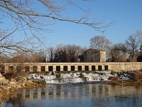 Vidourle river between Aubais and Villetelle


See also[edit]
References[edit]
- ^ "Répertoire national des élus: les maires". data.gouv.fr, Plateforme ouverte des données publiques françaises (in French). 2 December 2020.
- ^ "Populations légales 2021" (in French). The National Institute of Statistics and Economic Studies. 28 December 2023.
- ^ Population en historique depuis 1968, INSEE
External links[edit]
| Authority control databases: National |
|---|