
Original file (1,413 × 1,600 pixels, file size: 1.16 MB, MIME type: image/jpeg)
Summary
| Description |
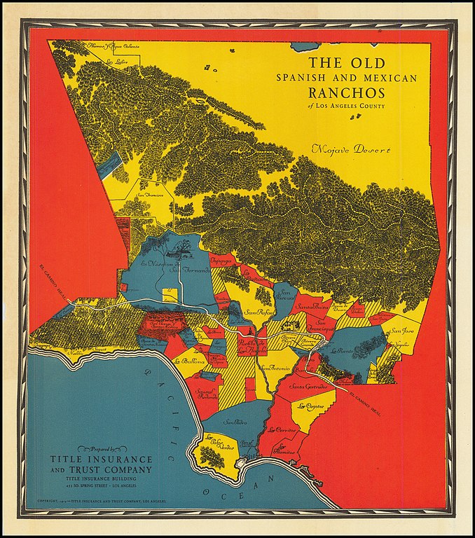
English: Old Spanish and Mexican Ranchos of Los Angeles County (Title Insurance & Trust Company, 1929) |
| Date | |
| Source |
https://www.raremaps.com/gallery/detail/82653/the-old-spanish-and-mexican-ranchos-of-los-angeles-county-title-insurance-trust-company Barry Lawrence Ruderman Antique Maps The Earliest of the Pictorial Maps of the Spanish & Mexican Ranchos Published for Title Insurance and Trust Company of Los Angeles Rare early Spanish & Mexican Ranchos map, prepared for the Title Insurance and Trust Company of Los Angeles. This 1929 map is very rare, pre-dating the Gerald Eddy map first issued in the late 1930s and a rare 1930 map by Young & McCallister. The later editions by Eddy would become an iconic early image of Southern California, issued from about 1937 into the 1950s. The present map provides a simple effective set of bright color swaths, locating the major Ranchos in Los Angeles County, along with the El Camino Real and depictions of Mission San Fernando and San Gabriel. Condition Description Folding map on thin paper. Related Categories Antique Maps / United States / California / Los Angeles |
| Author | Title Insurance and Trust Company |
Licensing
This work is in the public domain because it was published in the United States between 1929 and 1963, and although there may or may not have been a copyright notice, the copyright was not renewed. For further explanation, see Commons:Hirtle chart and the copyright renewal logs. Note that it may still be copyrighted in jurisdictions that do not apply the rule of the shorter term for US works (depending on the date of the author's death), such as Canada (70 years p.m.a.), Mainland China (50 years p.m.a., not Hong Kong or Macao), Germany (70 years p.m.a.), Mexico (100 years p.m.a.), Switzerland (70 years p.m.a.), and other countries with individual treaties.
|
 |
File history
Click on a date/time to view the file as it appeared at that time.
| Date/Time | Thumbnail | Dimensions | User | Comment | |
|---|---|---|---|---|---|
| current | 01:07, 15 March 2023 | | 1,413 × 1,600 (1.16 MB) | Jengod | Uploaded a work by Title Insurance and Trust Company from https://www.raremaps.com/gallery/detail/82653/the-old-spanish-and-mexican-ranchos-of-los-angeles-county-title-insurance-trust-company Barry Lawrence Ruderman Antique Maps The Earliest of the Pictorial Maps of the Spanish & Mexican Ranchos Published for Title Insurance and Trust Company of Los Angeles Rare early Spanish & Mexican Ranchos map, prepared for the Title Insurance and Trust Company of Los Angeles. This 1929 map is very rar... |
.jpg)