
Size of this preview: 755 × 600 pixels. Other resolutions: 302 × 240 pixels | 604 × 480 pixels | 967 × 768 pixels | 1,280 × 1,017 pixels | 2,560 × 2,034 pixels | 2,699 × 2,144 pixels.
Original file (2,699 × 2,144 pixels, file size: 685 KB, MIME type: image/png)
Summary
| Description |
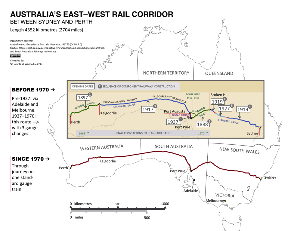
English: Map of Australia's east-west rail corridor before and after gauge standardisation in 1970 |
| Date | |
| Source | Own work |
| Author | SCHolar44 |
Licensing
I, the copyright holder of this work, hereby publish it under the following license:
| This file is made available under the Creative Commons CC0 1.0 Universal Public Domain Dedication. | |
| The person who associated a work with this deed has dedicated the work to the public domain by waiving all of their rights to the work worldwide under copyright law, including all related and neighboring rights, to the extent allowed by law. You can copy, modify, distribute and perform the work, even for commercial purposes, all without asking permission.
|
File history
Click on a date/time to view the file as it appeared at that time.
| Date/Time | Thumbnail | Dimensions | User | Comment | |
|---|---|---|---|---|---|
| current | 09:58, 13 September 2023 | | 2,699 × 2,144 (685 KB) | SCHolar44 | (By original uploader): Add extra source details; mark broad gauge; minor re-wording |
| 04:47, 1 March 2022 |  | 1,798 × 1,428 (371 KB) | SCHolar44 | Amended ambiguous words in 1927-1970 note | |
| 03:12, 1 March 2022 |  | 1,798 × 1,428 (363 KB) | SCHolar44 | By original uploader: route re-drawn to scale, added pre-1970 corridor and more detail | |
| 10:50, 4 July 2020 |  | 1,753 × 1,618 (356 KB) | SCHolar44 | Added names of other significant points; added to key. | |
| 11:09, 15 April 2020 |  | 2,645 × 2,401 (570 KB) | SCHolar44 | Uploaded own work with UploadWizard |
File usage
The following pages on the English Wikipedia use this file (pages on other projects are not listed):
Global file usage
The following other wikis use this file:
- Usage on hi.wikibooks.org
- Usage on ru.wikipedia.org