No higher resolution available.
Lambay_Island_-_Reachrainn_-_geograph.org.uk_-_1350641.jpg (640 × 427 pixels, file size: 44 KB, MIME type: image/jpeg)
Summary
| Description |
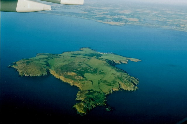
English: Lambay Island (Irish: Reachrainn) seen from an Aer Lingus Airbus A330 preparing to land at Dublin Airport in Ireland. The yellow headland at Portrane Desmesne called Quay juts out from the coast in the background, with the small town of Portrane in the bay to the right (north) of it. |
| Date | |
| Source | From geograph.org.uk |
| Author | Joseph Mischyshyn |
| Camera location | | View this and other nearby images on: OpenStreetMap |
|---|
Licensing

|
This image was taken from the Geograph project collection. See this photograph's page on the Geograph website for the photographer's contact details. The copyright on this image is owned by Joseph Mischyshyn and is licensed for reuse under the Creative Commons Attribution-ShareAlike 2.0 license.
|
This file is licensed under the Creative Commons Attribution-Share Alike 2.0 Generic license.
Attribution: Joseph Mischyshyn
- You are free:
- to share – to copy, distribute and transmit the work
- to remix – to adapt the work
- Under the following conditions:
- attribution – You must give appropriate credit, provide a link to the license, and indicate if changes were made. You may do so in any reasonable manner, but not in any way that suggests the licensor endorses you or your use.
- share alike – If you remix, transform, or build upon the material, you must distribute your contributions under the same or compatible license as the original.
File history
Click on a date/time to view the file as it appeared at that time.
| Date/Time | Thumbnail | Dimensions | User | Comment | |
|---|---|---|---|---|---|
| current | 08:03, 28 February 2011 | | 640 × 427 (44 KB) | GeographBot | == {{int:filedesc}} == {{Information |description={{en|1=Ireland's Eye - Inis Mac Neasain As seen from an Aer Lingus Airbus A330 perparing to land at Dublin airport.}} |date=2005-09-06 |source=From [http://www.geograph.org.uk/photo/1350641 geograph.org.uk |
File usage
The following pages on the English Wikipedia use this file (pages on other projects are not listed):
Global file usage
The following other wikis use this file:
- Usage on br.wikipedia.org
- Usage on de.wikipedia.org
- Usage on fr.wikipedia.org
- Usage on ga.wikipedia.org
- Usage on hu.wikipedia.org
- Usage on it.wikipedia.org
- Usage on no.wikipedia.org
- Usage on uk.wikipedia.org
- Usage on zh.wikipedia.org