Birchleaf, Virginia | |
|---|---|
 Post Office in Birchleaf | |
 Birchleaf  Birchleaf | |
| Coordinates: 37°10′38″N 82°16′20″W / 37.17722°N 82.27222°W | |
| Country | United States |
| State | Virginia |
| County | Dickenson |
| Elevation | 1,299 ft (396 m) |
| Time zone | UTC-5 (Eastern (EST)) |
| • Summer (DST) | UTC-4 (EDT) |
| GNIS feature ID | 1495271[1] |
Birchleaf is an unincorporated community in Dickenson County, Virginia, United States. The population was 761 at the 2000 census.
Birchleaf was likely named for the birch timber in the area.[2]
Geography[edit]
Birchleaf is located approximately 5 miles SE of the town of Haysi, Virginia. The Russell Fork of the Levisa River runs through the center of the community. Frequent flooding of this river has resulted in a floodplain in which most of the community is located.
One of the most destructive floods occurred in 1977, the infamous "Flood of '77" as referred to by local residents. Over $20 million in damage occurred to this and other small communities along the Russell Fork River in April 1977.
Education[edit]
Birchleaf is served by Sandlick Elementary School and Ridgeview High School. Southwest Virginia Community College also runs a bus to nearby Richlands, Virginia.
References[edit]
- ^ U.S. Geological Survey Geographic Names Information System: Birchleaf, Virginia
- ^ Tennis, Joe (2004). Southwest Virginia Crossroads: An Almanac of Place Names and Places to See. The Overmountain Press. p. 10. ISBN 978-1-57072-256-1.

Municipalities and communities of Dickenson County, Virginia, United States | ||
|---|---|---|
| Towns | 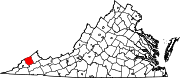 | |
| CDPs | ||
| Unincorporated communities | ||
| Footnotes | ‡This populated place also has portions in an adjacent county or counties | |