No edit summary |
No edit summary |
||
| Line 45: | Line 45: | ||
*[http://www.satsentinel.org Satellite Sentinel Project] |
*[http://www.satsentinel.org Satellite Sentinel Project] |
||
*[http://www.unitar.org/unosat/sudan UNOSAT] |
*[http://www.unitar.org/unosat/sudan UNOSAT] |
||
*[http://www.notonourwatchproject.org Not On Our Watch] |
|||
*[http://www.enoughproject.org The Enough Project] |
|||
Revision as of 13:40, 25 March 2011
 | |
| Founded | 2010 |
|---|---|
| Type | Non-Profit Organization |
| Focus | Human Rights, Civilian Protection, and Peace |
| Location | |
| Method | Satellite Images and Analysis |
| Website | Satellite Sentinel Project |

March 6, 2011
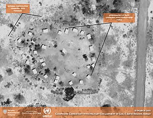
The Satellite Sentinel Project was conceived by George Clooney during an October 2010 visit to Southern Sudan with Enough Project Co-Founder, John Prendergast.[1] It combines satellite imagery analysis and field reports using Google's Map Maker technology, as well as employing on-the-ground video, further corroborating the analysis of the satellite imagery, to deter the resumption of war between North and South Sudan. The project provides an early warning system to deter mass atrocities by focusing world attention and generating rapid responses on human rights and human security concerns. The Satellite Sentinel Project, or SSP, was first to confirm the razings of the villages of Maker Abior, Todach, and Tajalei in Sudan's contested Abyei region.
This project is the result of a collaboration between Not On Our Watch, the Enough Project, Google, UNITAR/UNOSAT: the United Nations Institute for Training and Research (UNITAR) Operational Satellite Applications Programme (UNOSAT), DigitalGlobe, the Harvard Humanitarian Initiative, and Trellon.[2]
Not On Our Watch provided seed money to launch the Satellite Sentinel Project. The Enough Project contributes field reports and policy analysis, and, together with Not On Our Watch and its SUDANNOW partners, pressures policymakers by urging the public to act. UNITAR/UNOSAT analyzes satellite images and collaborates with Google and Trellon to design the web platform. Harvard Humanitarian Initiative provides research and leads the collection, human rights analysis, and corroboration of on-the-ground reports that contextualizes the imagery. DigitalGlobe provides satellite imagery and additional analysis.
References
Further Reading
- Satellite Images Show Build-up of Northern Forces in Sudan’s Abyei Region, By Joe DeCapua, Voice of America, March 23, 2011
- Satellites Offer New Window into Documenting, Preventing Genocide, By Tom Bearden, PBS NewsHour, March 17, 2011
- Rival troops build up in Sudan's Abyei: satellite, Reuters, March 11, 2011
- U.S. warns that standoff in Sudan is 'unacceptable', By Alan Boswell, The Miami Herald, March 9, 2011
- ‘Ground Truthing’ Satellite Images of Violence in Sudan, By Andrew C. Revkin, The New York Times, March 8, 2011
- Orbiting Eyes Capture Sudan Village Destruction, By Andrew C. Revkin, The New York Times, March 7, 2011
- Signs of Razing in Contested Part of Sudan, By Josh Kron, The New York Times, March 7, 2011
- A 21st-Century Statesman, By John Avlon, Newsweek, February 21, 2011
- Satellite Sentinel Project Uses Commercial Satellite Imagery to Monitor Sudanese Conflict, By Susan Smith, GISCafé, February 14, 2011
- UPDATE: Paparazzi Descend on...Genocide?, By Virginia Prescott, New Hampshire Public Radio, Thursday, January 27, 2011
- Clooney's satellite project shows troops near Sudan's border, By Andrew Meldrum, GlobalPost, January 26, 2011
- Harvard Researchers Monitor Violence in Sudan, By Jane Seo, Harvard Crimson, January 05, 2011
- Harvard team to analyze Sudan satellite images, By Bryan Bender, The Boston Globe, December 29, 2010
- Clooney's 'Antigenocide Paparazzi': Watching Sudan, By Mark Benjamin, Time, December 28, 2010
- George Clooney and Harvard give resonance to UNITAR work, United Nations Institute for Training and Research