
Size of this preview: 800 × 558 pixels. Other resolutions: 320 × 223 pixels | 640 × 446 pixels | 985 × 687 pixels.
Original file (985 × 687 pixels, file size: 66 KB, MIME type: image/png)
Summary
| Description |
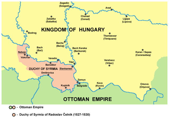
English: historic map - Duchy of Syrmia of Radoslav Čelnik (1527-1530) - English language version
Српски / srpski: историјска карта - Сремско војводство Радослава Челника (1527-1530. године) - верзија на енглеском језику |
| Date | 16 March 2009 (original upload date) |
| Source | No machine-readable source provided. Own work assumed (based on copyright claims). |
| Author | No machine-readable author provided. PANONIAN assumed (based on copyright claims). |
References
- Veselin P. Dželetović, Poslednji srpski car - Jovan Nenad, Poeta - Beograd, 2007.
- Dr Aleksa Ivić, Istorija Srba u Vojvodini, Novi Sad, 1929.
- Drago Njegovan, Prisajedinjenje Vojvodine Srbiji, Novi Sad, 2004.
- Dr. Dušan J. Popović, Srbi u Vojvodini, knjiga 1, Novi Sad, 1990.
- Vladimir Ćorović, Ilustrovana istorija Srba, knjiga četvrta, Beograd, 2006.
- The Times History of Europe, Times Books, 2002.
- http://www.crohis.com/ssrkulj2/mohac.htm
- http://www.hervardi.com/images/slovenijeh039.jpg
- http://www.croatia-in-english.com/images/maps/1606.jpg
Source and licence
self made map by user:PANONIAN
Licensing
| I, the copyright holder of this work, release this work into the public domain. This applies worldwide. In some countries this may not be legally possible; if so: I grant anyone the right to use this work for any purpose, without any conditions, unless such conditions are required by law. |
File history
Click on a date/time to view the file as it appeared at that time.
| Date/Time | Thumbnail | Dimensions | User | Comment | |
|---|---|---|---|---|---|
| current | 14:09, 14 April 2015 | | 985 × 687 (66 KB) | PANONIAN | corrections |
| 19:55, 19 October 2011 |  | 985 × 687 (65 KB) | WikiEditor2004 | corrected borders | |
| 09:20, 27 September 2011 |  | 988 × 687 (65 KB) | WikiEditor2004 | aesthetics | |
| 09:47, 14 September 2009 |  | 988 × 687 (65 KB) | WikiEditor2004 | Reverted to version as of 15:49, 25 July 2009 - thumbnail problem with new version, trying to fix | |
| 09:47, 14 September 2009 |  | 576 × 431 (32 KB) | WikiEditor2004 | Reverted to version as of 22:37, 16 March 2009 - thumbnail problem with new version, trying to fix | |
| 15:49, 25 July 2009 |  | 988 × 687 (65 KB) | WikiEditor2004 | ||
| 22:37, 16 March 2009 |  | 576 × 431 (32 KB) | WikiEditor2004 | historic map - Duchy of Syrmia of Radoslav Čelnik - English version (self made) {{PD-self}} Category:Maps of the history of Serbia Category:Maps of the history of Vojvodina |
File usage
The following pages on the English Wikipedia use this file (pages on other projects are not listed):
Global file usage
The following other wikis use this file:
- Usage on it.wikipedia.org
- Usage on ja.wikipedia.org
- Usage on sh.wikipedia.org
- Usage on tr.wikipedia.org