| Colonia Dacica Sarmizegetusa | |
|---|---|
 Bronze head of the Roman emperor Decius found at the site. | |
 Location within Romania | |
| Alternative name(s) | Colonia Dacica Sarmizegetusa, Zarmizegethusa,[1] Sarmategte,[1] Sarmazege[1] |
| Founded during the reign of | Trajan |
| Founded | 2nd century AD |
| Attested by | Tabula Peutingeriana |
| Place in the Roman world | |
| Province | Dacia |
| Structure | |
| — Stone structure — | |
| Size and area | 600 m × 540 m (32.4 ha) |
| Shape | Round rectangle |
| — Wood and earth[2] structure — | |
| Stationed military units | |
| — Legions — | |
| Location | |
| Coordinates | 45°30′47″N 22°47′14″E / 45.5130°N 22.7873°E |
| Altitude | c. 500 m |
| Town | Sarmizegetusa |
| County | Hunedoara |
| Country | |
| Reference | |
| RO-LMI | HD-I-s-A-03205[3] |
| RO-RAN | 91063.01[3] |
| Site notes | |
| Recognition | |
| Condition | Ruined |
Colonia Ulpia Traiana Augusta Dacica Sarmizegetusa was the capital and the largest city of Roman Dacia, later named Ulpia Traiana Sarmizegetusa after the former Dacian capital, located some 30 km away. Possibly built over a camp of the Fifth Macedonian Legion in about 106 AD, the city was settled by veterans and colonists from Italian peninsula.[4] From the very beginning it received the title of colonia and the status of ius Italicum.[5] The urban centre and the civil settlement occupied an area of over 130 hectares (320 acres; 0.50 sq mi), with a population reaching between 20,000 and 25,000 at the end of the 2nd century beginning of the 3rd. The centre built in a Hippodamian Plan was surrounded by strong fortifications over 32.4 hectares (80 acres; 0.125 sq mi).[6]
After the abandonment of Dacia, the population size drastically fell. A small community moved inside the amphitheatre, walling the entrances with funerary stones, surviving until the end of the 4th century.[7] Today Ulpia Traiana remains in ruins, with a partly preserved forum, an amphitheatre, and remnants of several temples.
Location[edit]

The settlement was built at a distance of 8 km from Tapae, a pass between Banat and Transylvania (today known as the Iron Gates of Transylvania). The choice was based on the military and economic advantages given by the natural barrier represented by the Retezat Mountains in the south and Poiana Ruscă Mountains in the north. The territory of the metropolis extended from Tibiscum to Micia and to the Jiu valley, the city being protected by several castra: Tibiscum, Pons Augusti, Micia and castra of Bumbești.[8]
The city at the crossroad of the imperial road from the Drobeta that linked the north of the province with Porolissum (Moigrad) and the one starting form Dierna going towards Tibiscum.[9]
History[edit]

The urban centre was built during the time of the second governor of Dacia, Decimus Terentius Scaurianus, and acted as the governor's seat until it was moved to Apulum.[5] From an inscription discovered at the beginning of the 14th century in the village of Grădişte, it is known that the new town was settled in the first years after the conquest of Dacia (106 AD). The inscription reads: "On the command of the emperor Caesar Nerva Traianus Augustus, son of the divine Nerva, was settled the Dacian Colony by Decimus Terentius Scaurianus, its governor." In Rome, the settlement of the colony was marked by the minting of a coin, by order of the Senate, dedicated to emperor Trajan.
The first stage of building was the walled urban area by a detachment of Legio IV Flavia Felix. In the interior there were the public and administrative buildings as well as private residences organised as insulae. At the centre of it was the forum vetus. The entry was marked by a tetrapylon placed at the intersection of the two main streets with each side ornated with a fountain dedicated to the nymphs. South of the forum vetus, on the place of an old market, a new forum was built around 153 with a Capitolium at its western side. Besides the temple dedicated to the Capitoline Triad, which marked the city as the religious centre of Dacia, in the beginning of the 3rd century a temple for the Palmyrene gods was dedicated. Northeast of the new forum was the building of the fiscal procurator of Dacia Apulensis.[10]
The civil settlement continued outside the walls, mainly to the North, covering over 100 hectares. The most important building was the amphitheatre, initially built of wood then from the second half of the 2nd century from stone. East of the amphitheatre was the sacred area with multiple temples and sanctuaries. South was a large area for Roman baths.[11]
During the reign of Hadrian the city was renamed Colonia Ulpia Traiana Augusta Dacica Sarmizegetusa. Between 222 and 235 the colony was called a metropolis.[12] The name was found on a stone inscription that reads "To Gaius Arrius Quadratus, son of Gaius, acting praetor of the emperor in Colonia Ulpia Traiana Augusta Dacica Sarmizegetusa."[13] Gaius Arrius Antoninus bore the title legatus pro praetore, which was the official title of the governor of some imperial provinces of the Roman Empire.
The city was the main residence of the Cominia gens in Dacia.[14]
Archeological site[edit]

Today, the archeological site contains the following remains:
- Amphitheatre
- Gladiator school
- Goddess Nemesis Temple
- Liber Pater Temple
- Gods Aesculapius and Hygieia Temple
- Temple Basilica
- Temple of god Mithra
- Temple of the Palmyrenes
- Great Temple
- God Silvanus Temple
- Glass blowers' workshops
- Horreum
- Financial procurator's office
- Thermae
- Forum
Image gallery[edit]
-
 Votive plaque showing Silvanus
 -
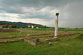
 Inscription on the Forum Column
 -
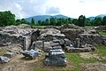
 The Great Temple
 -
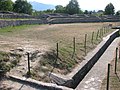 The Amphitheatre
 -
 Column ornament
 -
 Temple of Nemesis
 -
 Curia
Curia -
 Glass workshop
 -
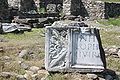
 Roman tablet built into the medieval Orthodox church in Sânpetru.
 -
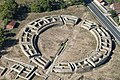 Aerial view
 -
 The frontispiece of the forum:
In honorem domus divinae L(ucius) Ophonius Pap(iria) Domitius Priscus IIvir col(oniae) Dacic(ae) pecunia sua fecit l(ocus) d(atus) d(ecreto) d(ecurionum) -
 Aplique with the shape of Gorgona Medusa discovered at the site


See also[edit]
Notes[edit]
- ^ a b c Schütte, Gudmund (1917). "Ptolemy's maps of northern Europe, a reconstruction of the prototypes". The Royal Danish Geographical Society. Retrieved 2013-05-04.
- ^ a b Dumitru Protase: Castrul legiunii IIII Flavia de la Berzovia. Săpăturile arheologice din anii 1965–1968, p.41 Archived 2012-03-10 at the Wayback Machine
- ^ a b "Colonia Ulpia Traiana Augusta Dacica Sarmizegetusa". National Archaeological Record of Romania (RAN). ran.cimec.ro. 2012-08-08. Retrieved 2014-03-20.
- ^ Witschel, Christian (2021). "Römische Außenpolitik: Kaiser Trajan, die Dakerkriege und die Donauprovinzen". academia.edu (in German). p. 40. Retrieved 27 August 2023.
- ^ a b Witschel 2021, p. 40.
- ^ "Repertoriul Arheologic Naţional". ran.cimec.ro. Retrieved 2023-08-27.
- ^ "Repertoriul Arheologic Naţional". ran.cimec.ro. Retrieved 2023-08-27.
- ^ Marcu, Felix; Cupcea, George (2023). "The Topography of Colonia Ulpia Traiana Augusta Dacica Sarmizegetusa and the First Centuriation of Dacia". uni-heidelberg.de. p. 543. Retrieved 27 August 2023.
- ^ Marcu, Felix; Cupcea, George (2023). "The Topography of Colonia Ulpia Traiana Augusta Dacica Sarmizegetusa and the First Centuriation of Dacia". uni-heidelberg.de. p. 543. Retrieved 27 August 2023.
- ^ "Repertoriul Arheologic Naţional". ran.cimec.ro. Retrieved 2023-08-27.
- ^ "Repertoriul Arheologic Naţional". ran.cimec.ro. Retrieved 2023-08-27.
- ^ Marcu, Felix; Cupcea, George (2023). "The Topography of Colonia Ulpia Traiana Augusta Dacica Sarmizegetusa and the First Centuriation of Dacia". uni-heidelberg.de. pp. 544–545. Retrieved 27 August 2023.
- ^ AE 1931, 124
- ^ Byros, Gabriela (August 2023). "Reconstructing Identities in Roman Dacia: Evidence from Religion". academia.edu. Retrieved 27 August 2023.
External links[edit]
- (in English) ULPIA TRAIANA SARMIZEGETUSA
- (in Romanian) ULPIA TRAIANA SARMIZEGETUSA Archived 2009-06-20 at the Wayback Machine
| International | |
|---|---|
| National | |
| Geographic | |
| Other | |