reset defininition to that of the original 2004 version (http://en.wikipedia.org/w/index.php?title=Western_Montana&oldid=10211109) |
Add map |
||
| Line 1: | Line 1: | ||
{{for|the college|University of Montana - Western}} |
{{for|the college|University of Montana - Western}} |
||
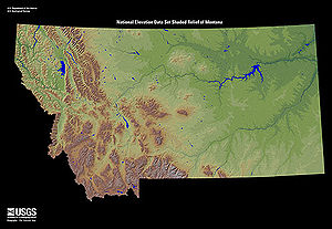
'''Western Montana''' is the western much more mountainous region of the state of [[Montana]], United States . Western Montana<ref>http://en.wikipedia.org/w/index.php?title=Western_Montana&oldid=10211109</ref> basically encompasses the western third of the state roughly on a dividing line running north from Yellowstone park through Helena and Browning to the Canadian border. It includes the mountainous parts of Montana including the Continental divide and the eastern slope of the Rocky Mountains. It also includes Glacier National Park, Bob Marshall Wilderness Area, Flathead Lake, Missoula, Kalispell, Hamilton, and Whitefish; and the counties of Lincoln, Flathead, Sanders, Missoula, Lake, Ravali, Pondera, Deer Lodge, Powell, Silverbow, Gallatin, Mineral, Teton, Glacier, Jefferson, Granite, Broadwater, Madison, and Lewis and Clark. |
'''Western Montana''' is the western much more mountainous region of the state of [[Montana]], United States . Western Montana<ref>http://en.wikipedia.org/w/index.php?title=Western_Montana&oldid=10211109</ref> basically encompasses the western third of the state roughly on a dividing line running north from Yellowstone park through Helena and Browning to the Canadian border. It includes the mountainous parts of Montana including the Continental divide and the eastern slope of the Rocky Mountains. It also includes Glacier National Park, Bob Marshall Wilderness Area, Flathead Lake, Missoula, Kalispell, Hamilton, and Whitefish; and the counties of Lincoln, Flathead, Sanders, Missoula, Lake, Ravali, Pondera, Deer Lodge, Powell, Silverbow, Gallatin, Mineral, Teton, Glacier, Jefferson, Granite, Broadwater, Madison, and Lewis and Clark. |
||
[[File:Montana Relief 1.jpg|right|thumb|300px|'''Mountainous Western Montana''']] |
|||
==Geography, Biomes and Climate== |
==Geography, Biomes and Climate== |
||
Revision as of 00:10, 17 July 2011
Western Montana is the western much more mountainous region of the state of Montana, United States . Western Montana[1] basically encompasses the western third of the state roughly on a dividing line running north from Yellowstone park through Helena and Browning to the Canadian border. It includes the mountainous parts of Montana including the Continental divide and the eastern slope of the Rocky Mountains. It also includes Glacier National Park, Bob Marshall Wilderness Area, Flathead Lake, Missoula, Kalispell, Hamilton, and Whitefish; and the counties of Lincoln, Flathead, Sanders, Missoula, Lake, Ravali, Pondera, Deer Lodge, Powell, Silverbow, Gallatin, Mineral, Teton, Glacier, Jefferson, Granite, Broadwater, Madison, and Lewis and Clark.

Geography, Biomes and Climate

Western Montana that is dominated by the Rocky Mountains.[2] Most of Western Montana is covered in forest, prominent species being Ponderosa pine, aspen, and Rocky Mountain Douglas-fir.
Common fauna include the black bear, moose, elk, and coyote. The grizzly bear lives in Glacier National Park and the surrounding areas. [3]
Precipitation is lower in the valleys, which are mostly semiarid and receive 8 to 25 inches of precipitation, largely in snow, and higher in the mountains, some areas of which quality as temperate rainforest, especially in the northwest around Glacier National Park and Libby.
Winters are cold, sometimes bitterly cold and summers are warm.
History
Western Montana was originally inhabited by the Salish, Kootenai, Shoshone, Flathead, and Kalispel people. [4] In the late 19th century white people arrived and established mines and cities in the mountains and valleys.
Gold was discovered in Last Chance Gulch in the 1860's and soon the city of Helena was born. [5] Today Helena is the State capitol of Montana. Helena still has much of the charm of a 19th century mining town. Many of the old buildings have been renovated and hundreds of 19th century victorian homes and mansions fill Helena's old neighborhoods. Helena is one of the best preserved mining towns on the Western frontier. Copper was discovered In Butte and the surrounding areas in the 1870's. Vast quantities of copper were mined, leaving behind the largest Superfund clean up site in the history of the nation.[6] Copper is still mined at Berkeley Pit in Butte. Missoula is the largest city in Western Montana and the second-largest in the state after Billings.
Western Montana though fairing better than much of the nation is still the portion of the state hit hardest by the current economic downturn. [7][8]Places like Missoula have been hit hard with the devastation of its timber industry. The closing of the Smurfit Stone's Mill in 2009 alone is expected to cause the loss of over 2000 jobs through 2012.[9] Missoula has lost some of its retail base with the loss of major nation retailers such as Macys.[10] Much of western Montana has felt the effects of a housing bust as well.[11]
Cities
See also
References
- ^ http://en.wikipedia.org/w/index.php?title=Western_Montana&oldid=10211109
- ^ http://www.destination360.com/north-america/us/montana/rocky-mountains
- ^ http://www.bigskyfishing.com/National_parks/glacier/bears.shtm
- ^ http://www.native-languages.org/montana.htm
- ^ http://www.westernmininghistory.com/towns/montana/helena/
- ^ http://www.bigskyfishing.com/Montana-Info/butte_mt-2.shtm
- ^ http://missoulian.com/mobile/article_f0444dba-08ac-11df-a3cc-001cc4c002e0.html
- ^ http://missoulian.com/news/local/article_09e8183a-dd89-11df-a8c1-001cc4c002e0.html
- ^ http://www.kaj18.com/news/economic-effects-of-smurfit-stone-closure-still-being-felt/#!prettyPhoto/0/
- ^ http://missoulian.com/news/local/article_e2eb258c-fa1d-11de-8935-001cc4c002e0.html
- ^ http://www.bozemandailychronicle.com/news/article_dc20cf12-a027-11df-beeb-001cc4c03286.html