mNo edit summary |
BernardTom (talk | contribs) m updating infobox |
||
| Line 1: | Line 1: | ||
{{Infobox City |
{{Infobox City |
||
| official_name = Atyrau |
| official_name = Atyrau |
||
| native_name = Атырау |
| native_name = Атырау |
||
| image_skyline = Manjali mosque atyrau.JPG|The Central Mosque "Imangali" (in honour to Imangali Tasmagambetov) |
| image_skyline = Manjali mosque atyrau.JPG|The Central Mosque "Imangali" (in honour to Imangali Tasmagambetov) |
||
| image_flag = |
| image_flag = |
||
| Line 9: | Line 9: | ||
|subdivision_type = [[Countries of the world|Country]] |
|subdivision_type = [[Countries of the world|Country]] |
||
|subdivision_type1 = [[Provinces of Kazakhstan|Province]] |
|subdivision_type1 = [[Provinces of Kazakhstan|Province]] |
||
|subdivision_name = [[Image:Flag of Kazakhstan.svg|right|30px]] [[Kazakhstan]] |
|subdivision_name = [[Image:Flag of Kazakhstan.svg|right|30px]] [[Kazakhstan|The Republic of Kazakhstan]] |
||
|subdivision_name1 = [[Atyrau Province]] |
|subdivision_name1 = [[Atyrau Province]] |
||
| established_title = Founded |
| established_title = Founded |
||
| Line 33: | Line 33: | ||
| population_density_km2 = |
| population_density_km2 = |
||
| timezone = [[Bhutan Time|BTT]] |
| timezone = [[Bhutan Time|BTT]] |
||
| utc_offset = + |
| utc_offset = +5 |
||
| timezone_DST = |
| timezone_DST = |
||
| utc_offset_DST = |
| utc_offset_DST = |
||
| Line 42: | Line 42: | ||
| elevation_ft = |
| elevation_ft = |
||
| postal_code_type = [[Postal code]] |
| postal_code_type = [[Postal code]] |
||
| postal_code = |
| postal_code = 060001 - 060011 |
||
| area_code = |
| area_code = +7 7122 |
||
| website = |
| website = http://www.e-atyrau.kz |
||
| footnotes = |
| footnotes = |
||
}} |
}} |
||
Revision as of 16:10, 6 October 2007
Atyrau
Атырау | |
|---|---|
| File:Manjali mosque atyrau.JPG | |
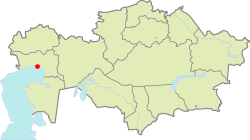
 Location of Atyrau | |
| Country | |
| Province | Atyrau Province |
| Founded | 1645 |
| Government | |
| • Mayor | Salimzhan Naqpayev |
| Population | |
| • Total | 320,000 |
| Time zone | UTC+5 (BTT) |
| Postal code | 060001 - 060011 |
| Area code | +7 7122 |
| Website | http://www.e-atyrau.kz |
Atyrau (Kazakh: Атырау, pronounced [ɑ tɾ ˈaw]; historical name Guriev) is a city in Kazakhstan, and the capital of Atyrau Province. It is located 2700 kilometers west of Almaty and 350 kilometers east of the Russian city of Astrakhan. Other transliterations include Aterau, Atirau, Atyraw, Atırav, Atıraw.
Geography
Atyrau is Kazakhstan's main harbour city on the Caspian Sea at the delta of the Ural River. Atyrau city is approximately 20 meters below sea level. The city is considered by many to be located both in Asia and Europe, as it is divided by the Ural River, which is often considered the boundary between Europe and Asia.
History
The wooden fort at the mouth of the Yaik River was founded in 1645 under the name of Nizhny Yaitzky gorodok (literally, Lower Yaik Fort) by the Russian trader Mikhaylo Guryev, a native of Yaroslavl, who specialized in trade with Khiva and Bukhara. The fort was plundered by the Yaik Cossacks, leading the Guriev family to rebuild it in stone (1647-62). Tsar Alexis sent a garrison of Streltsy to protect the fort from Cossack incursions. Despite these efforts, the Cossack rebel Stepan Razin held the town in 1667 and 1668. The fort gradually lost its strategic significance and was demolished in 1810. Between 1708 and 1992 the city was known as Guriev.
Modern city
Modern Atyrau is famous for its oil and fish industries. It has 142,500 inhabitants (1999 census), almost 80% ethnic Kazakhs, the rest being mostly Russians and other ethnic groups such as Koreans and Bulgars. Since October 2006, its mayor is Salimzhan Naqpayev.
