Penn Township | |
|---|---|
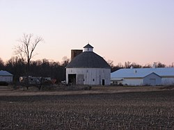
 The Rebecca Rankin Round Barn, a township landmark | |
 Location in Jay County | |
| Coordinates: 40°31′45″N 85°09′29″W / 40.52917°N 85.15806°W | |
| Country | United States |
| State | Indiana |
| County | Jay |
| Government | |
| • Type | Indiana township |
| Area | |
| • Total | 30.21 sq mi (78.2 km2) |
| • Land | 30.19 sq mi (78.2 km2) |
| • Water | 0.02 sq mi (0.05 km2) 0.07% |
| Elevation | 892 ft (272 m) |
| Population | |
| • Total | 1,133 |
| • Density | 38/sq mi (14/km2) |
| GNIS feature ID | 0453712 |
Penn Township is one of twelve townships in Jay County, Indiana, United States. As of the 2020 census, its population was 1,133 (down from 1,239 at 2010[2]) and it contained 530 housing units.[1]
History[edit]
Penn Township was named in honor of William Penn.[3]
The Rebecca Rankin Round Barn was listed on the National Register of Historic Places in 1993.[4]
Geography[edit]
According to the 2010 census, the township has a total area of 30.21 square miles (78.2 km2), of which 30.19 square miles (78.2 km2) (or 99.93%) is land and 0.02 square miles (0.052 km2) (or 0.07%) is water.[2] The streams of Brooks Creek and Haines Creek run through this township.
Cities and towns[edit]
Unincorporated towns[edit]
Adjacent townships[edit]
- Nottingham Township, Wells County (north)
- Jackson Township (east)
- Greene Township (southeast)
- Knox Township (south)
- Harrison Township, Blackford County (west)
Cemeteries[edit]
The township contains three cemeteries: Hillside, Maple Lawn and West Grove.
Major highways[edit]
References[edit]
- ^ a b "Census Bureau profile: Penn Township, Jay County, Indiana". United States Census Bureau. May 2023. Retrieved April 6, 2024.
- ^ a b "Population, Housing Units, Area, and Density: 2010 - County -- County Subdivision and Place -- 2010 Census Summary File 1". United States Census. Archived from the original on February 12, 2020. Retrieved May 10, 2013.
- ^ Jay, Milton T. (1922). History of Jay County, Indiana: Including Its World War Record and Incorporating the Montgomery History, Volume 1. Historical Publishing Company. p. 96.
- ^ "National Register Information System". National Register of Historic Places. National Park Service. July 9, 2010.
