
Size of this preview: 733 × 600 pixels. Other resolutions: 293 × 240 pixels | 587 × 480 pixels | 939 × 768 pixels | 1,199 × 981 pixels.
Original file (1,199 × 981 pixels, file size: 705 KB, MIME type: image/png)
Summary
| Description |
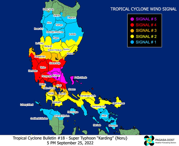
English: A color-coded map showing the Tropical Cyclone Wind Signal (TCWS) levels issued at 5:00 PM PhST on September 25, 2022 by the Philippine Atmospheric, Geophysical, and Astronomical Services Administration (PAGASA) over most of Luzon, Philippines due to Typhoon Noru (locally known as "Karding"). As per PAGASA analysis, Noru attained Super Typhoon intensity (based on PAGASA's tropical cyclone intensity scale) which warranted the issuance of Wind Signal #5, the highest and worst TCWS level, indicated by purple shaded areas in the map (areas which are nearest to the eyewall of the typhoon). |
| Date | |
| Source | https://bagong.pagasa.dost.gov.ph/tropical-cyclone/severe-weather-bulletin |
| Author | Philippine Atmospheric, Geophysical, and Astronomical Services Administration (PAGASA) |
Licensing
| This work is in the public domain in the Philippines and possibly other jurisdictions because it is a work created by an officer or employee of the Government of the Philippines or any of its subdivisions and instrumentalities, including government-owned and/or controlled corporations, as part of their regularly prescribed official duties; consequently, any work is ineligible for copyright under the terms of Part IV, Chapter I, Section 171.11 and Part IV, Chapter IV, Section 176 of Republic Act No. 8293 and Republic Act No. 10372, as amended, unless otherwise noted. However, in some instances, the use of this work in the Philippines or elsewhere may be regulated by this law or other laws.
|

|
File history
Click on a date/time to view the file as it appeared at that time.
| Date/Time | Thumbnail | Dimensions | User | Comment | |
|---|---|---|---|---|---|
| current | 05:18, 12 December 2022 | | 1,199 × 981 (705 KB) | Nairb.Idi9 | Uploaded a work by Philippine Atmospheric, Geophysical, and Astronomical Services Administration (PAGASA) from https://bagong.pagasa.dost.gov.ph/tropical-cyclone/severe-weather-bulletin with UploadWizard |
File usage
The following pages on the English Wikipedia use this file (pages on other projects are not listed):
_due_to_Typhoon_Noru_(Karding),_5_PM_PhST,_25_September_2022.png)