
Size of this preview: 450 × 600 pixels. Other resolutions: 180 × 240 pixels | 480 × 640 pixels.
Original file (480 × 640 pixels, file size: 88 KB, MIME type: image/jpeg)
This is a photo of listed building number 1160126. |
Summary
| Description |
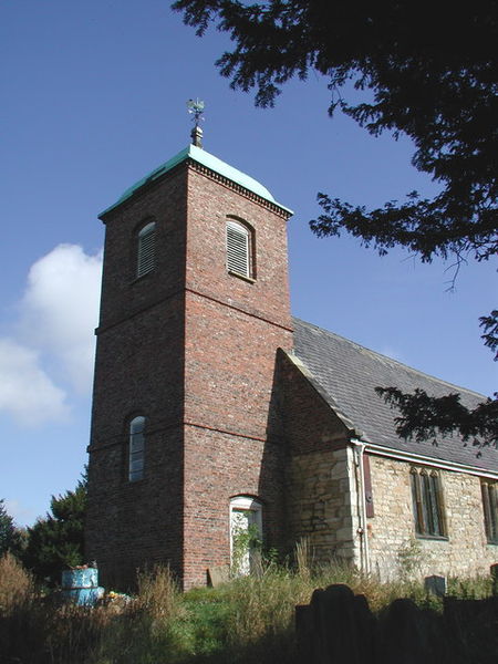
English: St Helen's, Barmby on the Marsh, East Riding of Yorkshire, England. During the reign of Henry VIII a tithe barn at Barmby was converted into a chapel with the addition of a chancel and a wooden tower with a spire. By 1773 the wooden tower at St. Helen's was considered unsafe and replaced with the present dome-capped brick steeple at a cost of £120. The chancel was rebuilt and the rest of the church restored in 1870. Much of the old graveyard has apparently been abandoned to nature and a new burial ground has been laid out recently at Barmby Cutting to the east of the village. |
| Date | |
| Source | From geograph.org.uk |
| Author | Paul Glazzard |
| Permission (Reusing this file) |
Creative Commons Attribution Share-alike license 2.0 |
| Camera location | | View this and other nearby images on: OpenStreetMap |
|---|
Licensing

|
This image was taken from the Geograph project collection. See this photograph's page on the Geograph website for the photographer's contact details. The copyright on this image is owned by Paul Glazzard and is licensed for reuse under the Creative Commons Attribution-ShareAlike 2.0 license.
|
This file is licensed under the Creative Commons Attribution-Share Alike 2.0 Generic license.
Attribution: Paul Glazzard
- You are free:
- to share – to copy, distribute and transmit the work
- to remix – to adapt the work
- Under the following conditions:
- attribution – You must give appropriate credit, provide a link to the license, and indicate if changes were made. You may do so in any reasonable manner, but not in any way that suggests the licensor endorses you or your use.
- share alike – If you remix, transform, or build upon the material, you must distribute your contributions under the same or compatible license as the original.
File history
Click on a date/time to view the file as it appeared at that time.
| Date/Time | Thumbnail | Dimensions | User | Comment | |
|---|---|---|---|---|---|
| current | 21:55, 10 December 2009 | | 480 × 640 (88 KB) | Keith D | == Summary == {{Information |Description=St Helen's, Barmby on the Marsh, East Riding of Yorkshire During the reign of Henry VIII a tithe barn at Barmby was converted into a chapel with the add |
File usage
The following pages on the English Wikipedia use this file (pages on other projects are not listed):
Global file usage
The following other wikis use this file:
- Usage on it.wikipedia.org
- Usage on www.wikidata.org