
Size of this preview: 800 × 600 pixels. Other resolutions: 320 × 240 pixels | 640 × 480 pixels | 1,024 × 768 pixels | 1,280 × 960 pixels | 2,048 × 1,536 pixels.
Original file (2,048 × 1,536 pixels, file size: 731 KB, MIME type: image/jpeg)
| Description |
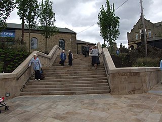
Glossop is a village in Derbyshire on the edge of Greater Manchester. Henry Street staircase from Norfolk Square to the Station.
|
||||
| Date | 4 July 2008 (upload date) | ||||
| Source | Own work | ||||
| Author | Clem Rutter, Rochester Kent | ||||
| Permission (Reusing this file) |
Own work, copyleft: Multi-license with GFDL and Creative Commons CC-BY-SA-2.5 and older versions (2.0 and 1.0) |
I, the copyright holder of this work, hereby publish it under the following licenses:

|
Permission is granted to copy, distribute and/or modify this document under the terms of the GNU Free Documentation License, Version 1.2 or any later version published by the Free Software Foundation; with no Invariant Sections, no Front-Cover Texts, and no Back-Cover Texts. A copy of the license is included in the section entitled GNU Free Documentation License. |
| This file is licensed under the Creative Commons Attribution-Share Alike 3.0 Unported license. | ||
| ||
| This licensing tag was added to this file as part of the GFDL licensing update. |
This file is licensed under the Creative Commons Attribution-Share Alike 2.5 Generic, 2.0 Generic and 1.0 Generic license.
- You are free:
- to share – to copy, distribute and transmit the work
- to remix – to adapt the work
- Under the following conditions:
- attribution – You must give appropriate credit, provide a link to the license, and indicate if changes were made. You may do so in any reasonable manner, but not in any way that suggests the licensor endorses you or your use.
- share alike – If you remix, transform, or build upon the material, you must distribute your contributions under the same or compatible license as the original.
You may select the license of your choice.
File history
Click on a date/time to view the file as it appeared at that time.
| Date/Time | Thumbnail | Dimensions | User | Comment | |
|---|---|---|---|---|---|
| current | 23:11, 4 July 2008 | | 2,048 × 1,536 (731 KB) | ClemRutter | {{Information |Description={{w:Glossop|Glossop}} is a village in {{w:Derbyshire|Derbyshire}} on the edge of Greater Manchester. Henry Street staircase from Norfolk Square to the Station. {{location dec|53.4438|-1.9496}} |Source=Self-made |Date=4/7/2008 | |
File usage
The following pages on the English Wikipedia use this file (pages on other projects are not listed):
Global file usage
The following other wikis use this file:
- Usage on azb.wikipedia.org