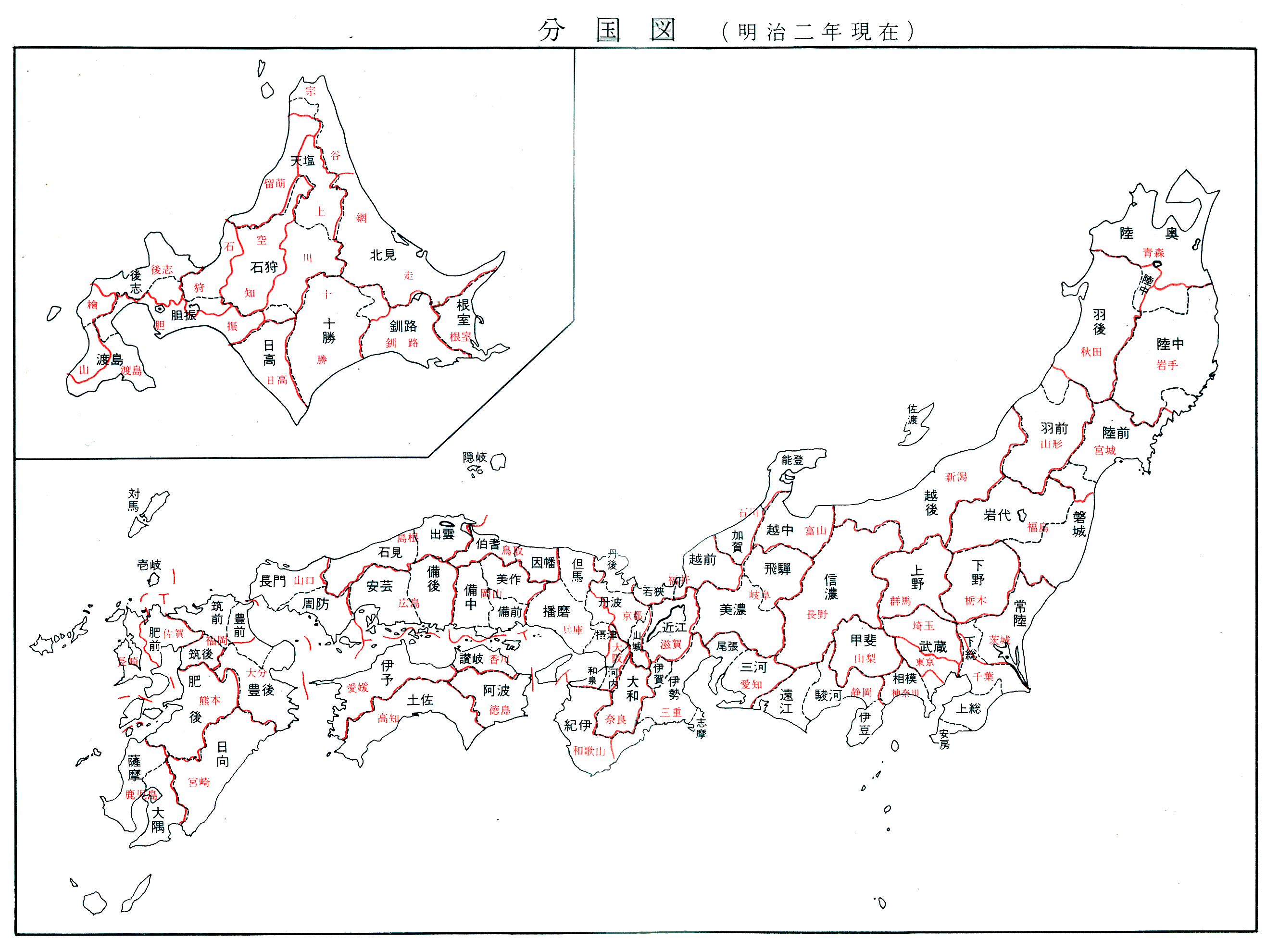
The geography and administrative subdivisions of Japan have evolved and changed during the course of its history. These were sometimes grouped according to geographic position.[1][2]
Kinai[edit]
- Yamashiro
- southern Kyoto
- Yamato (northern Nara without Yoshino)
- entire Nara
- Yoshino (created from Yamato in 716, later rejoined back in 738)
- southern Nara (Yoshino District + Gojō city)
- Kawachi
- eastern Osaka
- Izumi (created in 716 from Kawachi, then rejoined back in 740, later re-split in 757)
- southern/southwestern Osaka
- Settsu
Tōkaidō[edit]
Tōkaidō literally means 'Eastern Sea Way'.[3] The term also identifies a series of roads connecting the 15 provincial capitals of the region.[4]
- Iga (created in 680 from Ise)
- Ise
- central/northern/southern Mie
- Shima (created at the beginning of the 8th century from Ise)
- Owari
- Mikawa
- Tōtōmi
- Suruga
- Izu (created 680 from Suruga)
- eastern Shizuoka (Izu Peninsula)
- Tokyo (Izu Islands)
- Kai
- entire Yamanashi
- Sagami
- southwestern Kanagawa (most)
- Musashi (transferred in 771 from Tōsandō)
- Awa (created in 718 from Kazusa, then rejoined back in 741, later re-split in 781)
- southern Chiba
- Kazusa (broke off from Fusa in the 7th century)
- central Chiba
- Shimōsa (broke off from Fusa in the 7th century)
- northern Chiba
- southeastern Ibaraki (around Kashima)
- part of Saitama (west portion of the Edogawa River)
- Hitachi
- central/northeastern Ibaraki
Tōsandō[edit]
The Tōsandō is a region which straddles the central mountains of northern Honshū.[5] The descriptive name also refers to a series of roads connecting the provincial capitals.[4] Tōsandō included Musashi Province after 711.[5]
- Ōmi
- entire Shiga
- Mino
- southern Gifu
- Hida
- Shinano
- Suwa (created in 721 from Shinano, later rejoined back in 731)
- Kōzuke (broke off from Kenu during the 4th century)
- entire Gunma
- Shimotsuke (broke off from Kenu during the 4th century)
- entire Tochigi
- Uzen (broke off from Dewa during the Meiji Restoration in 1868)
- southeastern Yamagata (most)
- Ugo (broke off from Dewa during the Meiji Restoration in 1868)
- Mutsu (created in the 7th century from Hitachi)
- Iwashiro (created during the Meiji Restoration in 1868 from Mutsu)
- western/central Fukushima
- Iwaki (created during the Meiji Restoration in 1868 from Mutsu)
- Rikuchū (created during the Meiji Restoration in 1868 from Mutsu)
- Rikuzen (created during the Meiji Restoration in 1868 from Mutsu)
- southeastern Iwate (Kesen District; and the cities of Rikuzentakata, Ōfunato and south portion of Kamaishi)
- entire Miyagi
Hokurikudō[edit]
- Wakasa
- southern/western Fukui
- Echizen (broke off from Koshi during the end of the 7th century)
- northern/eastern Fukui
- Kaga (created in 823 from Echizen)
- southern/western Ishikawa
- Noto (created in 718 from Echizen, then occupied in 741 by Etchū, later re-split in 757 from Etchū)
- northern/eastern Ishikawa
- Etchū (broke off from Koshi during the end of the 7th century)
- entire Toyama
- Echigo (broke off from Koshi during the end of the 7th century)
- entire Niigata (most)
- Sado (occupied in 743 by Echigo, later re-split in 752)
San'indō[edit]
- Tanba
- Tango (created in 713 from Tamba)
- northern Kyoto
- Tajima
- northern/northwestern Hyōgo
- Inaba
- eastern Tottori
- Hōki
- western Tottori
- Izumo
- eastern Shimane
- Iwami
- western Shimane
- Oki
San'yōdō[edit]
- Harima
- southern/southwestern Hyōgo
- Mimasaka (created in 713 from Bizen)
- northeastern Okayama
- Bizen (broke off from Kibi during the 2nd half of the 7th century)
- southeastern Okayama
- Bitchū (broke off from Kibi during the 2nd half of the 7th century)
- western Okayama
- Bingo (broke off from Kibi during the 2nd half of the 7th century)
- eastern Hiroshima
- Aki
- western Hiroshima
- Suō
- eastern Yamaguchi
- Nagato
- western Yamaguchi
Nankaidō[edit]
Saikaidō[edit]
- Buzen (broke off from Toyo at the end of the 7th century)
- northeastern Fukuoka Prefecture
- northwestern Ōita Prefecture
- Bungo (broke off from Toyo at the end of the 7th century)
- central/southeastern Ōita Prefecture (most)
- Chikuzen (broke off from Tsukushi no later than the end of the 7th century)
- central/northwestern Fukuoka Prefecture (most)
- Chikugo (broke off from Tsukushi no later than the end of the 7th century)
- southern Fukuoka Prefecture
- Hizen (broke off from Hi no later than the end of the 7th century)
- Higo (broke off from Hi no later than the end of the 7th century)
- Hyūga
- Ōsumi (created in 702 from Hyūga)
- eastern Kagoshima
- Tane (created in 702 from Hyūga, later occupied in 824 by Ōsumi)
- Kagoshima (Tanegashima and Yakushima Islands)
- Satsuma (created in 702 from Hyūga)
- western Kagoshima
- Iki (officially Iki-shima)
- Tsushima (officially Tsushima-jima)
Hokkaidō[edit]
- Oshima
- southern Oshima Subprefecture
- southern Hiyama Subprefecture
- Shiribeshi
- most of Shiribeshi Subprefecture (excluding Abuta District)
- northern Hiyama Subprefecture
- Iburi
- entire Iburi Subprefecture
- Yamakoshi District, in Oshima Subprefecture
- Abuta District, in Shiribeshi Subprefecture
- Chitose and Eniwa cities, in Ishikari Subprefecture
- Shimukappu village, Kamikawa Subprefecture
- Ishikari
- most of Ishikari Subprefecture (excluding Chitose and Eniwa cities)
- entire Sorachi Subprefecture
- southern Kamikawa Subprefecture (excluding Shimukappu village)
- Teshio
- entire Rumoi Subprefecture
- northern Kamikawa Subprefecture
- Kitami
- entire Sōya Subprefecture
- most of Abashiri Subprefecture (excluding part of Abashiri District)
- Hidaka
- entire Hidaka Subprefecture
- Tokachi
- entire Tokachi Subprefecture
- Kushiro
- entire Kushiro Subprefecture
- part of Abashiri District, in Abashiri Subprefecture
- Nemuro
- entire Nemuro Subprefecture
- Chishima (the islands of Kunashiri and Etorofu, later included Shikotan and the Kuril Islands)
Notes[edit]
- ^ Nussbaum, Louis-Frédéric. (2005). "Provinces and prefectures" in Japan Encyclopedia, p. 780, p. 780, at Google Books; excerpt, "Japan's former provinces were converted into prefectures by the Meiji government ... [and] grouped, according to geographic position, into the 'five provinces of the Kinai' and 'seven circuits'."
- ^ Henry Smith's Home Page http://www.columbia.edu/~hds2/19th/kuni_vs_ken.gif
- ^ Nussbaum, "Tōkaidō" at p. 973, p. 973, at Google Books.
- ^ a b Titsingh, Isaac. (1834). Annales des empereurs du japon, p. 57., p. 57, at Google Books
- ^ a b Nussbaum, "Tōsandō" at p. 988, p. 988, at Google Books.
References[edit]
- Nussbaum, Louis-Frédéric and Käthe Roth. (2005). Japan encyclopedia. Cambridge: Harvard University Press. ISBN 978-0-674-01753-5; OCLC 58053128
- Titsingh, Isaac. (1834). Annales des empereurs du Japon (Nihon Ōdai Ichiran). Paris: Royal Asiatic Society, Oriental Translation Fund of Great Britain and Ireland. OCLC 5850691