| Mount Mangengenge | |
|---|---|
 Mount Mangengenge | |
| Highest point | |
| Elevation | 718 m (2,356 ft) |
| Coordinates | 4°26′15″S 15°31′26″E / 4.4375°S 15.5238°E |
| Geography | |
| Location | Democratic Republic of the Congo |
| Region | Kinshasa |
Mount Mangengenge is a mountain of the Democratic Republic of the Congo located southeast of Kinshasa, about ten kilometers south of the Ndjili International Airport. It is part of the Crystal Mountains range. The mountain can be reached from the outskirts of the parish of Sainte Angèle de Mérici, along a track hardly passable.
The name Mangengenge derives from the Lingala word kongenge, which means "shining". The mountain was first called Mabangu or Manguel until 1866, then Pic Mense from 1867, in honor of Carl Mense (1861—1938 ), who with Hans von Schwerin, was the first European to climb the mountain.
Overlooking the plain of the Pool Malebo, it reaches an altitude of 718 meters. The path of the ascent is punctuated with crucifix sculptures with a large cross at the summit. This is because the Bishop of Kinshasa, Frederic Etsou Nzabi Bamungwabi took the initiative in 1992 to make it a spiritual place. Since, several million pilgrims have climbed the peak.
-
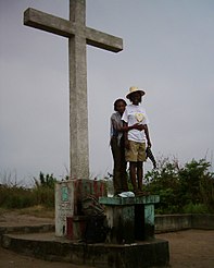 The cross at the summit of Mount Mangengenge
 -
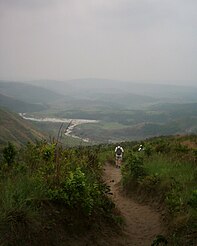 Descent over the Malebo Pool plains

