Volcanoguy (talk | contribs) m fixing region parameter to prep for merging range template using AWB |
removed Category:Kinshasa using HotCat |
||
| (23 intermediate revisions by 11 users not shown) | |||
| Line 1: | Line 1: | ||
{{Orphan|date=January 2012}} |
|||
{{Infobox mountain |
{{Infobox mountain |
||
| name = Mount Mangengenge |
| name = Mount Mangengenge |
||
| photo = Mont Mangengenge 2.jpg |
| photo = Mont Mangengenge 2.jpg |
||
| photo_caption = Mount Mangengenge |
| photo_caption = Mount Mangengenge |
||
| elevation_m = 718 |
| elevation_m = 718 |
||
| elevation_ref = |
| elevation_ref = |
||
| |
| prominence_m = |
||
| prominence_ref= |
|||
| map = |
|||
| range = [[Crystal Mountains (Africa)|Crystal Mountains]] |
|||
| listing = |
| listing = |
||
| |
| country = [[Democratic Republic of the Congo]] |
||
| ⚫ | |||
| range = |
|||
| region_type = [[Provinces of the Democratic Republic of the Congo|Province]] | region = [[Kinshasa]] |
|||
| lat_d = | lat_m = | lat_s = | lat_NS = N |
|||
| ⚫ | |||
| long_d = | long_m = | long_s = | long_EW = E |
|||
| coordinates_ref= |
|||
| region_code = [[Kinshasa]] |
|||
| first_ascent = June 1885 by [[Carl Anton Mense]] |
|||
| coordinates = |
|||
| first_ascent = |
|||
| easiest_route = |
| easiest_route = |
||
| province = |
|||
}} |
}} |
||
'''Mount Mangengenge''' |
'''Mount Mangengenge''' is a [[mountain]] of the [[Democratic Republic of the Congo]] located southeast of [[Kinshasa]], about ten kilometers south of the [[Ndjili International Airport]]. It is part of the [[Crystal Mountains (Africa)|Crystal Mountains]] range. The mountain can be reached from the outskirts of the parish of Sainte Angèle de Mérici, along a track hardly passable. |
||
==Toponymy== |
|||
The name ''Mangengenge'' derives from the [[Lingala]] word ''kongenge'', which means "shining". The mountain was first called ''Mabangu'' or '' |
The name ''Mangengenge'' derives from the [[Lingala]] word ''kongenge'', which means "shining". The mountain was first called ''Mabangu'' or ''Manguele''. |
||
==History== |
|||
| ⚫ | |||
In June 1885<ref>{{cite web|language=de |title=Carl Anton Mense |url=https://de.m.wikipedia.org/wiki/Carl_Anton_Mense}}.</ref> |
|||
| ⚫ | |||
, the medical doctor [[Carl Anton Mense]] (1861–1938) was the first European to climb the mountain. To remember this historical ascent, the mountain was called "pic Mense" for almost a century. |
|||
| ⚫ | |||
==Geography== |
|||
{{-}} |
|||
Overlooking the plain of the [[Pool Malebo]], it reaches an altitude of {{convert|718|m|ft|0}}, which makes it the highest point in Kinshasa. |
|||
== |
==Religion== |
||
| ⚫ | The path of the ascent is punctuated with crucifix sculptures with a large cross at the summit. This is because the Bishop of Kinshasa, [[Frederic Etsou Nzabi Bamungwabi]] took the initiative in 1992 to make it a spiritual place. Since then, thousands and thousands of pilgrims have climbed the peak. |
||
| ⚫ | |||
==Tourism== |
|||
| ⚫ | |||
Being the highest point of [[Kinshasa]] and a rather beautiful and natural site, the mountain is also a significant tourist spot. There are about 100 foreign tourists ascending it every single month, all year round. |
|||
==World Cleanup Day== |
|||
[[Category:Kinshasa]] |
|||
A couple of participants of the [[World Cleanup Day]]<ref>{{cite web|url=https://www.worldcleanupday.org|title=Find Your Team|website=worldcleanupday.org}}</ref> collected garbage left by pilgrims and tourists for the first time in September 2019. Their aim is to keep doing it two or three times a year. They hope that other tourists and pilgrims will start doing it as well. |
|||
| ⚫ | |||
==Gallery== |
|||
<gallery mode=packed heights=165> |
|||
| ⚫ | |||
| ⚫ | |||
</gallery> |
|||
==References== |
|||
{{Reflist}} |
|||
==External links== |
|||
| ⚫ | |||
{{DEFAULTSORT:Mangengenge}} |
|||
{{DRC-geo-stub}} |
|||
[[Category:Mountains of the Democratic Republic of the Congo]] |
|||
Revision as of 21:52, 23 August 2023
| Mount Mangengenge | |
|---|---|
 Mount Mangengenge | |
| Highest point | |
| Elevation | 718 m (2,356 ft) |
| Coordinates | 4°26′15″S 15°31′26″E / 4.4375°S 15.5238°E |
| Geography | |
 Mount Mangengenge | |
| Country | Democratic Republic of the Congo |
| Province | Kinshasa |
| Parent range | Crystal Mountains |
| Climbing | |
| First ascent | June 1885 by Carl Anton Mense |
Mount Mangengenge is a mountain of the Democratic Republic of the Congo located southeast of Kinshasa, about ten kilometers south of the Ndjili International Airport. It is part of the Crystal Mountains range. The mountain can be reached from the outskirts of the parish of Sainte Angèle de Mérici, along a track hardly passable.
Toponymy
The name Mangengenge derives from the Lingala word kongenge, which means "shining". The mountain was first called Mabangu or Manguele.
History
In June 1885[1] , the medical doctor Carl Anton Mense (1861–1938) was the first European to climb the mountain. To remember this historical ascent, the mountain was called "pic Mense" for almost a century.
Geography
Overlooking the plain of the Pool Malebo, it reaches an altitude of 718 metres (2,356 ft), which makes it the highest point in Kinshasa.
Religion
The path of the ascent is punctuated with crucifix sculptures with a large cross at the summit. This is because the Bishop of Kinshasa, Frederic Etsou Nzabi Bamungwabi took the initiative in 1992 to make it a spiritual place. Since then, thousands and thousands of pilgrims have climbed the peak.
Tourism
Being the highest point of Kinshasa and a rather beautiful and natural site, the mountain is also a significant tourist spot. There are about 100 foreign tourists ascending it every single month, all year round.
World Cleanup Day
A couple of participants of the World Cleanup Day[2] collected garbage left by pilgrims and tourists for the first time in September 2019. Their aim is to keep doing it two or three times a year. They hope that other tourists and pilgrims will start doing it as well.
Gallery
-
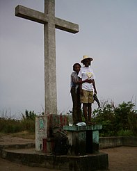 The cross at the summit of Mount Mangengenge
 -
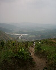 Descent over the Malebo Pool plains


References
- ^ "Carl Anton Mense" (in German)..
- ^ "Find Your Team". worldcleanupday.org.