m Open access bot: doi added to citation with #oabot. |
SphericalSong (talk | contribs) m →Geology: edited to better reflect current scientific debates on the origin of the igneous intrusions, with more reliable peer-reviewed sources Tag: Reverted |
||
| Line 30: | Line 30: | ||
==Geology== |
==Geology== |
||
Each hill in the chain consists of an erosional remnant of [[Cretaceous]] [[Intrusive rock|intrusive]] [[igneous]] [[rock (geology)|rock]] and associated [[hornfels]], which are more resistant to [[weathering]] than the surrounding [[sedimentary]] rock. All of the hills have dark-coloured [[mafic]] rock such as [[gabbro]] and [[essexite]]; some also have large areas of |
Each hill in the chain consists of an erosional remnant of [[Cretaceous]] [[Intrusive rock|intrusive]] [[igneous]] [[rock (geology)|rock]] and associated [[hornfels]], which are more resistant to [[weathering]] than the surrounding [[sedimentary]] rock. All of the hills have dark-coloured [[mafic]] rock such as [[gabbro]] and [[essexite]]; some also have large areas of pulaskite, [[syenite]], and other light-coloured rock.{{citation needed|date=August 2014}} |
||
The Monteregian Hills are the eroded remnants of [[Igneous intrusion|plutons]] emplaced around 140-118 [[megaannum|Ma]] in [[Precambrian]], [[Cambrian|Cambro]]-[[Ordovician]], and Lower [[Paleozoic]] [[Sedimentary rock|sedimentary]] and [[Metasedimentary rock|metasedimentary]] strata in the [[Grenville Province]] of the [[Canadian Shield]], the adjacent [[Great Lakes–St. Lawrence Lowlands|St. Lawrence Lowlands]], and the foothills of the [[Appalachian Mountains]].<ref>{{cite book |last=Eby |first=G.N. |editor-last1=Fitton |editor-first1=J.G. |editor-last2=Upton |editor-first2=B.G.J. |title=Alkaline Igneous Rocks, Geological Society Special Publication No. 30 |publisher=Blackwell |date=1987 |pages=433-447 |chapter=The Monteregian Hills and White Mountain alkaline igneous provinces, eastern North America |doi=10.1144/GSL.SP.1987.030.01.21}}</ref><ref>{{cite journal |last1=Feininger |first1=T. |last2=Goodacre |first2=A.K. |date=1995 |title=The eight classical Monteregian hills at depth and the mechanism of their intrusion |url=https://cdnsciencepub.com/doi/10.1139/e95-109 |journal=Canadian Journal of Earth Sciences |volume=32 |issue=9 |pages=1350-1364 |doi=10.1139/e95-109}}</ref> |
|||
The Monteregian Hills are part of the [[Great Meteor hotspot track]], formed as a result of the [[North American Plate]] sliding westward over the long-lived [[New England hotspot]],<ref>{{Cite journal | doi=10.1038/nature05675| pmid=17377580| title=Seismic evidence for convection-driven motion of the North American plate| journal=Nature| volume=446| issue=7134| pages=428–431| year=2007| last1=Eaton| first1=David W.| last2=Frederiksen| first2=Andrew| bibcode=2007Natur.446..428E}}</ref> and are the [[erosion|eroded]] remnants of intrusive [[stock (geology)|stocks]]. These intrusive stocks have been variously interpreted as the feeder intrusions of long [[extinct volcano]]es, which would have been active about 125 million years ago,<ref name="SI">A Hundred-Million Year History of the Corner Rise and New England Seamounts http://www.oceanexplorer.noaa.gov/explorations/05stepstones/background/geologic_history/geologic_history.html {{Webarchive|url=https://www.webcitation.org/6Hnj5CJIn?url=http://oceanexplorer.noaa.gov/explorations/05stepstones/background/geologic_history/geologic_history.html |date=2013-07-02 }} Retrieved on 2007-08-01</ref><ref>The Monteregian Hills: Igneous Intrusions, http://geoscape.nrcan.gc.ca/montreal/heritage_e.php#mont {{webarchive|url=https://web.archive.org/web/20090426185205/http://geoscape.nrcan.gc.ca/montreal/heritage_e.php |date=2009-04-26 }} Natural Resources Canada, Geoscape Montreal, 2006-07-24</ref> or as intrusives that never breached the surface in volcanic activity.<ref>{{cite web |url=https://www.mcgill.ca/gault/sainthilaire/natural/geology/ |title=Archived copy |accessdate=2007-12-16 |url-status=dead |archiveurl=https://web.archive.org/web/20071220072350/http://www.mcgill.ca/gault/sainthilaire/natural/geology/ |archivedate=2007-12-20 }} Geology of Gault Nature Reserve, Mont St. Hilaire, McGill University</ref> The lack of an obvious track west of the Monteregian Hills may be due either to failure of the plume to penetrate the [[Canadian Shield]], to the lack of recognizable intrusions, or to strengthening of the plume when it approached the Monteregian Hills region. However, there is evidence the hotspot track extends northwestwards, including epeirogenic uplift, [[mantle (geology)|mantle]] velocity anomalies and [[kimberlite|kimberlitic]] volcanic features (e.g. the [[Attawapiskat kimberlite field|Attawapiskat]], [[Kirkland Lake kimberlite field|Kirkland Lake]] and [[Lake Timiskaming kimberlite field|Lake Timiskaming]] kimberlite fields) that become older away from the Monteregian Hills.<ref>{{cite journal|title=New insights into the lithosphere beneath the Superior Province from Rayleigh wave dispersion and receiver function analysis|journal=Geophysical Journal International|volume=169|issue=3|last1=Darbyshire|first1=Fione A.|last2=Eaton|first2=David W.|last3=Frederiksen|first3=Andrew W.|last4=Ertolahti|first4=Leila|year=2007|page=4|bibcode=2007GeoJI.169.1043D|doi=10.1111/j.1365-246X.2006.03259.x|doi-access=free}}</ref> |
|||
The origin of the intrusions is uncertain. One view is that they formed as the North American Plate moved over the [[New England hotspot]], a [[mantle plume]] which is thought also to have formed the [[White Mountains]] in [[New Hampshire]] around the same time and later the [[New England Seamounts|New England]], [[Corner Rise Seamounts|Corner Rise]], and [[Seewarte Seamounts|Seewarte]] [[Seamounts]]. <ref name=”Sleep1990”>{{cite journal |last1=Sleep |first1=N.H. |date=1990 |title=Monteregian hotspot track: A long‐lived mantle plume |url=https://agupubs.onlinelibrary.wiley.com/doi/10.1029/JB095iB13p21983 |journal=JGR: Solid Earth |volume=95 |issue=B13 |pages=21983-21990 |doi=10.1029/JB095iB13p21983}}</ref><ref>{{cite journal |last1=Duncan |first1=R.A. |date=1984 |title=Age progressive volcanism in the New England Seamounts and the opening of the central Atlantic Ocean |url=https://agupubs.onlinelibrary.wiley.com/doi/abs/10.1029/JB089iB12p09980 |journal=JGR: Solid Earth |volume=89 |issue=B12 |pages=9980-9990 |doi=10.1029/JB089iB12p09980}}</ref> The lack of an obvious hotspot track west of [[Montreal]] has been explained by proponents of the view in terms of failure of the plume to penetrate the Canadian Shield, a lack of recognisable intrusions due to erosion, or a strengthening of the plume as it reached the Grenville Province,<ref name=”Sleep1990”/> and progressively older [[kimberlite]] fields to the northwest from [[Finger Lakes]] to [[Rankin Inlet]] have been cited as evidence for the extension of the hotspot track.<ref>{{cite journal |last1=Heaman |first1=L.M. |last2=Kjarsgaard |first2=B.A. |date=2000 |title=Timing of eastern North American kimberlite magmatism: continental extension of the Great Meteor hotspot track? |url=https://www.sciencedirect.com/science/article/abs/pii/S0012821X00000790 |journal=Earth and Planetary Science Letters |volume=178 |issue=3-4 |pages=253-268 |doi=10.1016/S0012-821X(00)00079-0}}</ref> These kimberlites, however, are selected from a large number of kimberlites in North America, many of which are not located on any proposed hotspot track, so their statistical significance and consequent evidentiary value is questionable. Other difficulties for the hypothesis include a lack of age progression within much of the province, a lack of initial flood basalt, and a lack of precursory uplift.<ref name=”McHoneND”>{{cite web |url=http://www.mantleplumes.org/CAMP.html |title=Igneous features and geodynamic models of rifting and magmatism around the Central Atlantic Ocean |last1=McHone |first1=J.G. |website=MantlePlumes.org |access-date=12 November 2020}}</ref><ref name=”McHone1996”>{{cite journal |last1=McHone |first1=J.G. |date=1996 |title=Constraints on the mantle plume model for Mesozoic alkaline intrusions in northeastern North America |url=https://pubs.geoscienceworld.org/canmin/article-abstract/34/2/325/12749/Constraints-on-the-mantle-plume-model-for-Mesozoic?redirectedFrom=fulltext |journal=The Canadian Mineralogist |volume=34 |issue=2 |pages=325-334}}</ref> |
|||
| ⚫ | The shallow, rocky sandy loam soils of the summits are mostly covered in [[forest]]. Where the underlying rock is rich in [[olivine]], as over large areas of Mont Saint-Bruno and Mont Rougemont, these soils are classed as |
||
These and other issues have led a number of scientists to contend instead that the plutons of the Monteregian Hills (as well as those of the White Mountains and the formation of related seamounts) are the result of shallow [[decompression melting]] brought about by reactivation of [[Lithosphere|lithospheric]] structures due to intraplate stresses related to tectonic changes in the [[Atlantic Ocean]]. <ref name=”McHoneND”/><ref name=”McHone1996”/><ref>{{cite journal |last1=Faure |first1=S. |last2=Tremblay |first2=A. |last3=Angelier |first3=J. |date=1996 |title=State of intraplate stress and tectonism of northeastern America since Cretaceous times, with particular emphasis on the New England-Quebec igneous province |url=https://www.sciencedirect.com/science/article/pii/0040195195001131 |journal=Tectonophysics |volume=255 |issue=1-2 |pages=111-134 |doi=10.1016/0040-1951(95)00113-1}}</ref><ref name=”Matton2009”>{{cite journal |last1= Matton|first1=G. |last2= Jébrak |first2=M. |date=2009 |title=The Cretaceous Peri-Atlantic Alkaline Pulse (PAAP): Deep mantle plume origin or shallow lithospheric break-up? |url=https://www.sciencedirect.com/science/article/pii/S0040195109000092?casa_token=kf4q48TwaMYAAAAA:MUmsMKTOI21CS9W8yjPHsxeSPSAcsOqHLpF2ZOBMfFLxt2_xAJnwJT3MjJTbU1W6HIQjxH4#bib82 |journal=Tectonophysics |volume=469 |issue=1-4 |pages=1-12 |doi=10.1016/j.tecto.2009.01.001}}</ref> Both the Monteregian Hills and the White Mountains are located on a pre-existing zone of lithospheric weakness related to the opening of the [[Iapetus Ocean]] in late [[Proterozoic]] and early Cambrian time, and the emplacement of the plutons is strongly correlated with the opening of the South Atlantic and a consequent reorganisation of plate motion and reorientation of stress fields.<ref name=”Matton2009”/> [[Geochemistry|Geochemical]] and [[Isotope|isotopic]] analysis of the magmas is consistent with this hypothesis and indicates several heterogeneous shallow-mantle sources rather than a single plume. <ref name=”McHoneND”/><ref name=”McHone1996”/><ref>{{cite journal |last1=Roulleau |first1=E. |last2=Stevenson |first2=R. |date=2013 |title=Geochemical and isotopic (Nd–Sr–Hf–Pb) evidence for a lithospheric mantle source in the formation of the Monteregian Province (Quebec) |url=https://cdnsciencepub.com/doi/abs/10.1139/cjes-2012-0145 |journal=Canadian Journal of Earth Sciences |volume=50 |issue=6 |pages=650-666 |doi=10.1139/cjes-2012-0145}}</ref> |
|||
| ⚫ | The shallow, rocky sandy loam soils of the summits are mostly covered in [[forest]]. Where the underlying rock is rich in [[olivine]], as over large areas of Mont Saint-Bruno and Mont Rougemont, these soils are classed as dystric brunisol. [[Podzol]] tends to develop over rock which lacks olivine, although many of these podzols lack an eluvial (Ae) horizon. Lower slopes are covered with aprons of gravel or sand. The sandy soils are usually podzols with classic Ae development; they often have subsoil hardpan and are undesirable for agriculture. The free-draining gravels are preferred for [[apple]] orchards, which grow in thermal belts where cold air can drain to the valley floor.{{citation needed|date=August 2014}} |
||
{| class="wikitable" |
{| class="wikitable" |
||
Revision as of 19:59, 22 November 2020
| Monteregian Hills | |
|---|---|
 Three of the central Monteregian hills (from left: Mont Saint-Hilaire, Mont Rougemont and Mont Yamaska) viewed from space. | |
| Highest point | |
| Peak | Mont Megantic |
| Elevation | 1,105 m (3,625 ft) |
| Geography | |
| Country | Canada |
| Province | Quebec |
| Range coordinates | 45°28.7′N 73°2.4′W / 45.4783°N 73.0400°W |
| Geology | |
| Age of rock | Early Cretaceous |
The Monteregian Hills (French: Collines Montérégiennes) is a linear chain of isolated hills in Montreal and Montérégie, between the Laurentians and the Appalachians.
Etymology
The first definition of the Monteregian Hills came about in 1903 when Montreal geologist Frank Dawson Adams began referring to Mount Royal (Latin, Mons Regius) and hills of similar geology in the Saint Lawrence Lowlands as the "Royal Mountains" (French: montagnes royales).[1] Other hills in the chain included Mont Saint-Bruno, Mont Saint-Hilaire, Mont Saint-Grégoire, Mont Rougemont, Mont Yamaska, Mont Shefford, and Mont Brome.
It was only later that Mont Mégantic,[2] the Oka Hills, as well as the Saint-André and d'Iberville formations, were added to the list.[3]
Geology
Each hill in the chain consists of an erosional remnant of Cretaceous intrusive igneous rock and associated hornfels, which are more resistant to weathering than the surrounding sedimentary rock. All of the hills have dark-coloured mafic rock such as gabbro and essexite; some also have large areas of pulaskite, syenite, and other light-coloured rock.[citation needed]
The Monteregian Hills are the eroded remnants of plutons emplaced around 140-118 Ma in Precambrian, Cambro-Ordovician, and Lower Paleozoic sedimentary and metasedimentary strata in the Grenville Province of the Canadian Shield, the adjacent St. Lawrence Lowlands, and the foothills of the Appalachian Mountains.[4][5]
The origin of the intrusions is uncertain. One view is that they formed as the North American Plate moved over the New England hotspot, a mantle plume which is thought also to have formed the White Mountains in New Hampshire around the same time and later the New England, Corner Rise, and Seewarte Seamounts. [6][7] The lack of an obvious hotspot track west of Montreal has been explained by proponents of the view in terms of failure of the plume to penetrate the Canadian Shield, a lack of recognisable intrusions due to erosion, or a strengthening of the plume as it reached the Grenville Province,[6] and progressively older kimberlite fields to the northwest from Finger Lakes to Rankin Inlet have been cited as evidence for the extension of the hotspot track.[8] These kimberlites, however, are selected from a large number of kimberlites in North America, many of which are not located on any proposed hotspot track, so their statistical significance and consequent evidentiary value is questionable. Other difficulties for the hypothesis include a lack of age progression within much of the province, a lack of initial flood basalt, and a lack of precursory uplift.[9][10]
These and other issues have led a number of scientists to contend instead that the plutons of the Monteregian Hills (as well as those of the White Mountains and the formation of related seamounts) are the result of shallow decompression melting brought about by reactivation of lithospheric structures due to intraplate stresses related to tectonic changes in the Atlantic Ocean. [9][10][11][12] Both the Monteregian Hills and the White Mountains are located on a pre-existing zone of lithospheric weakness related to the opening of the Iapetus Ocean in late Proterozoic and early Cambrian time, and the emplacement of the plutons is strongly correlated with the opening of the South Atlantic and a consequent reorganisation of plate motion and reorientation of stress fields.[12] Geochemical and isotopic analysis of the magmas is consistent with this hypothesis and indicates several heterogeneous shallow-mantle sources rather than a single plume. [9][10][13]
The shallow, rocky sandy loam soils of the summits are mostly covered in forest. Where the underlying rock is rich in olivine, as over large areas of Mont Saint-Bruno and Mont Rougemont, these soils are classed as dystric brunisol. Podzol tends to develop over rock which lacks olivine, although many of these podzols lack an eluvial (Ae) horizon. Lower slopes are covered with aprons of gravel or sand. The sandy soils are usually podzols with classic Ae development; they often have subsoil hardpan and are undesirable for agriculture. The free-draining gravels are preferred for apple orchards, which grow in thermal belts where cold air can drain to the valley floor.[citation needed]
| Name | Height | Age | Coordinates | Location |
|---|---|---|---|---|
| St. Andrews formation | 130 metres (430 ft) | n/a | 45°55"N, 74°31'W | Saint-André-d'Argenteuil |
| Oka Hills | 249 metres (817 ft)[14] | n/a | 45°28'N, 74°5'W | Oka |
| Mount Royal | 233 metres (764 ft) | 118-138 myr | 45°30'23"N, 73°35'20"W | Montreal |
| Mont Saint-Bruno | 218 metres (715 ft) | 118-136 myr | 45°33'1"N, 73°19'09"W | Saint-Bruno-de-Montarville |
| Mont Saint-Hilaire | 411 metres (1,348 ft) | 135 myr | 45°33'8"N, 73°9'3"W | Mont-Saint-Hilaire |
| Mont Saint-Grégoire | 251 metres (823 ft) | 119 myr | 45°21'29"N, 73°09'08"W | Mont-Saint-Grégoire |
| Mont Rougemont | 381 metres (1,250 ft) | 137 myr | 45°28'36"N, 73°03'17"W | Rougemont |
| Mont Yamaska | 416 metres (1,365 ft) | 120-140 myr | 45°27'25"N, 72°52'19"W | Saint-Paul-d'Abbotsford |
| Mont Shefford | 526 metres (1,726 ft) | 120-130 myr | 45°21'49"N, 72°37'33"W | Shefford |
| Mont Brome | 553 metres (1,814 ft) | 118-138 myr | 45°16'59"N, 72°37'59"W | Bromont |
| Mont Mégantic | 1,105 metres (3,625 ft) | 128-133 myr | 45°27'20.5"N, 71°9'7.6"W | Notre-Dame-des-Bois |
Gallery
-
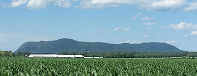
 Four of the Monteregian Hills in the late fall
 -
 Mont Saint-Hilaire from the south
 -
 aerial view of Mont Yamaska
 -
 Mont Rougemont as seen from Mt. Saint-Grégoire
 -
 Mont Mégantic as seen from the Stoke Mountains


See also
External links
- (in French) Les collines montérégiennes Geologic information about the chain
References
- ^ "Banque de noms de lieux du Québec: Reference number 76975". toponymie.gouv.qc.ca (in French). Commission de toponymie du Québec.
- ^ Feininger, Tomas; Goodacre, Alan K. (2003). "The distribution of igneous rocks beneath Mont Mégantic (the easternmost Monteregian) as revealed by gravity". Canadian Journal of Earth Sciences. 40 (5): 765–773. Bibcode:2003CaJES..40..765F. doi:10.1139/e03-022.
- ^ Bédard, Pierre. "La province géologique montérégienne : l'état des connaissances" (PDF) (in French). Communauté métropolitaine de Montréal. p. 6. Retrieved 22 August 2014.
Avec le progrès des connaissances géologiques, le mont Mégantic, les roches intrusives d'Iberville, d'Oka, et de Saint-André se sont progressivement ajoutés à la liste.
- ^ Eby, G.N. (1987). "The Monteregian Hills and White Mountain alkaline igneous provinces, eastern North America". In Fitton, J.G.; Upton, B.G.J. (eds.). Alkaline Igneous Rocks, Geological Society Special Publication No. 30. Blackwell. pp. 433–447. doi:10.1144/GSL.SP.1987.030.01.21.
- ^ Feininger, T.; Goodacre, A.K. (1995). "The eight classical Monteregian hills at depth and the mechanism of their intrusion". Canadian Journal of Earth Sciences. 32 (9): 1350–1364. doi:10.1139/e95-109.
- ^ a b Sleep, N.H. (1990). "Monteregian hotspot track: A long‐lived mantle plume". JGR: Solid Earth. 95 (B13): 21983–21990. doi:10.1029/JB095iB13p21983.
- ^ Duncan, R.A. (1984). "Age progressive volcanism in the New England Seamounts and the opening of the central Atlantic Ocean". JGR: Solid Earth. 89 (B12): 9980–9990. doi:10.1029/JB089iB12p09980.
- ^ Heaman, L.M.; Kjarsgaard, B.A. (2000). "Timing of eastern North American kimberlite magmatism: continental extension of the Great Meteor hotspot track?". Earth and Planetary Science Letters. 178 (3–4): 253–268. doi:10.1016/S0012-821X(00)00079-0.
- ^ a b c McHone, J.G. "Igneous features and geodynamic models of rifting and magmatism around the Central Atlantic Ocean". MantlePlumes.org. Retrieved 12 November 2020.
- ^ a b c McHone, J.G. (1996). "Constraints on the mantle plume model for Mesozoic alkaline intrusions in northeastern North America". The Canadian Mineralogist. 34 (2): 325–334.
- ^ Faure, S.; Tremblay, A.; Angelier, J. (1996). "State of intraplate stress and tectonism of northeastern America since Cretaceous times, with particular emphasis on the New England-Quebec igneous province". Tectonophysics. 255 (1–2): 111–134. doi:10.1016/0040-1951(95)00113-1.
- ^ a b Matton, G.; Jébrak, M. (2009). "The Cretaceous Peri-Atlantic Alkaline Pulse (PAAP): Deep mantle plume origin or shallow lithospheric break-up?". Tectonophysics. 469 (1–4): 1–12. doi:10.1016/j.tecto.2009.01.001.
- ^ Roulleau, E.; Stevenson, R. (2013). "Geochemical and isotopic (Nd–Sr–Hf–Pb) evidence for a lithospheric mantle source in the formation of the Monteregian Province (Quebec)". Canadian Journal of Earth Sciences. 50 (6): 650–666. doi:10.1139/cjes-2012-0145.
- ^ "Mont Bleu". Peakbagger.com. Retrieved 20 August 2014.