DachshundLover82 (talk | contribs) Undid revision 1010056677 by FleurDeOdile (talk) yes it is Tags: Undo Reverted |
FleurDeOdile (talk | contribs) Undid revision 1010059168 by DachshundLover82 (talk) low quality garbage images like that should be deleted Tags: Undo Reverted |
||
| Line 258: | Line 258: | ||
{{Infobox hurricane small |
{{Infobox hurricane small |
||
|Basin=Aus |
|Basin=Aus |
||
|Image=13S 2021-01- |
|Image=13S 2021-01-21 0355Z.jpg |
||
|Track=10U 2021 track.png |
|Track=10U 2021 track.png |
||
|Formed=19 January |
|Formed=19 January |
||
Revision as of 16:34, 3 March 2021
| 2020–21 Australian region cyclone season | |
|---|---|
 Season summary map | |
| Seasonal boundaries | |
| First system formed | 24 November 2020 |
| Last system dissipated | Season ongoing |
| Strongest storm | |
| Name | Marian |
| • Maximum winds | 150 km/h (90 mph) (10-minute sustained) |
| • Lowest pressure | 950 hPa (mbar) |
| Seasonal statistics | |
| Tropical lows | 17 |
| Tropical cyclones | 6 |
| Severe tropical cyclones | 1 |
| Total fatalities | 0 |
| Total damage | $10 million (2020 USD) |
| Related articles | |
The 2020–21 Australian region cyclone season is the period of the year when most tropical cyclones form in the Southern Indian Ocean and Pacific Oceans between 90°E and 160°E. The season officially began on 1 November 2020 and will end on 30 April 2021, however, a tropical cyclone could form at any time between 1 July 2020 and 30 June 2021 and would count towards the season total. During the season, tropical cyclones will be officially monitored by one of the three tropical cyclone warning centres (TCWCs) for the region which are operated by the Australian Bureau of Meteorology, National Weather Service of Papua New Guinea and the Indonesian Agency for Meteorology, Climatology and Geophysics. The United States Joint Typhoon Warning Center (JTWC) and other national meteorological services including Météo-France are also monitoring the basin during the season.
Season forecasts
In October 2020, Australia's Bureau of Meteorology (BOM) issued its tropical cyclone outlook for the 2020–21 season, and in the same month, the agency contributed towards the Southwest Pacific Tropical Cyclone Outlook, along with New Zealand's MetService, NIWA and the Fiji Meteorological Service (FMS). Each of the outlooks accounted for analogue seasons and the effects of various climate drivers, which included the state of the El Niño Southern Oscillation (ENSO). Below average sea surface temperatures in the eastern tropical Pacific Ocean and atmospheric conditions indicated a La Niña pattern, and it was declared that a La Niña had emerged on 29 September 2020. The BOM predicted that the La Niña pattern will persist into early 2021, and waters north of Australia and the Southwestern Pacific Ocean will be warmer than average in the coming three months.[1][2] The bureau also advised that cyclone kits include a supply of face masks and hand sanitisers, owing to the concurrent COVID-19 pandemic.[3]
The BOM expected an average to slightly above average number of tropical cyclones for the season. The agency predicted a 66% chance of above average activity for the region as a whole, compared with the average of 11 tropical cyclones. They also predicted that the Western and Northwestern sub-regions both had a 63% chance of experiencing more tropical cyclones than usual, the Northern region had a 57% chance of above average activity, and the Eastern region had a 67% chance of more tropical cyclones than the average.[1] The Northwestern sub-region had a probability of two tropical cyclones crossing the Western Australian coast, with a significant risk of at least one of these to be a severe tropical cyclone.[4]
The Southwest Pacific Tropical Cyclone Outlook covered a portion of the Australian region that comprised waters surrounding Papua New Guinea, the Solomon Islands, the Coral Sea, and the northern Tasman Sea including Norfolk Island. The outlook called for a reduced level of tropical cyclone activity in the early season, from November to January, but an increased level of activity in the late season, from February to April. Near normal activity during the season was expected for Papua New Guinea and the Solomon Islands, while an elevated level of activity was expected in the Coral Sea and the northern Tasman Sea, especially during the late season.[5]
Season summary

Systems
Tropical Low 01U (Bongoyo)
| Tropical low (Australian scale) | |
  | |
| Duration | 24 November – 30 November (Exited basin) |
|---|---|
| Peak intensity | 45 km/h (30 mph) (10-min); 1005 hPa (mbar) |
During mid to late November 2020, a moderate strength pulse of the Madden–Julian Oscillation (MJO) tracked eastwards across the equatorial Indian Ocean towards the Maritime Continent and Australian longitudes.[6][7] The presence of the MJO brought an increase in tropical moisture to the atmospheric environment, as well as aiding the formation of Tropical Cyclone Alicia in the South-West Indian Ocean region in mid November.[6][7] On 24 November, the Bureau of Meteorology (BOM) reported that a tropical low had developed within a trough in the far northwestern corner of the Australian region, located approximately 860 km (535 mi) northwest of the Cocos Islands.[8][9] The system was assigned the identifier code 01U by the BOM.[10] The Joint Typhoon Warning Center (JTWC) assessed environmental conditions as being only marginally conducive for tropical cyclogenesis, with good poleward outflow and sea surface temperatures near 30 °C (86 °F) being offset by the effects of moderate vertical wind shear.[11] Consequently, the tropical low was expected to have only a low chance of developing into a tropical cyclone prior to moving westwards out of the Australian region later in the week.[10][11]
Deep convection persisted over the system as the tropical low tracked gradually southwards over the following days, and by early 27 November, a curved convective rainband had developed on the eastern side.[12] Despite this, the system remained mostly disorganised in the marginal environment, with an elongated low-level circulation centre.[13] On 29 November, the tropical low began to be steered slowly towards the west-northwest on the northern side of the subtropical high pressure belt.[14][15] The system encountered somewhat weaker wind shear along its new track, allowing deep convection to develop closer to the low-level circulation centre.[16] Before any significant intensification could occur, however, the tropical low exited the Australian region on 30 November, passing into the area of responsibility of Météo-France's tropical cyclone warning centre in Réunion.[17] The system later intensified into Severe Tropical Storm Bongoyo in the South-West Indian Ocean cyclone region on 7 December.[18] At its peak intensity in the Australian region, the BOM estimated the system's minimum atmospheric pressure as 1005 hPa (29.68 inHg) on 25 November.[19] Satellite scatterometer data revealed maximum sustained winds of approximately 45 km/h (30 mph) at 02:30 UTC on 30 November, a few hours prior to the system exiting the Australian region.[20]
Tropical Low 01U made its closest approach to the Cocos Islands on 27–28 November, passing a little more than 500 km (310 mi) to the west.[21][22] Increased winds, as well as occasional showers and thunderstorms, occurred across the islands while the system was located nearby.[23] Maximum 10-minute sustained winds of 39 km/h (24 mph) with gusts to 46 km/h (29 mph) were observed at the airport on West Island at 04:30 UTC on 27 November.[24] A total of 23.6 mm (0.93 in) of rainfall was also recorded on 24–28 November.[25]
Tropical Low 02U
| Tropical low (Australian scale) | |
| Tropical storm (SSHWS) | |
  | |
| Duration | 6 December – 12 December |
|---|---|
| Peak intensity | 75 km/h (45 mph) (10-min); 991 hPa (mbar) |
On 6 December, the Bureau of Meteorology (BOM) reported that a tropical low had developed within a monsoon trough near the western end of Java, approximately 200 km (125 mi) north-northeast of Christmas Island.[26][27] The system was assigned the official identifier code 02U upon formation.[26] Initially located in an unfavourable environment for intensification, the tropical low began to encounter somewhat improved conditions as it tracked towards the southeast.[28][29] On 7 December, warm sea surface temperatures and strong diffluence in the upper troposphere fuelled the development of deep convection around the system's low-level circulation centre. Referencing the tropical low's quickly improving structure and the presence of a weak eye feature in microwave satellite imagery, the Joint Typhoon Warning Center (JTWC) issued a tropical cyclone formation alert for the system at 05:30 UTC.[28] After tracking in a clockwise path around the northeastern side of Christmas Island, Tropical Low 02U became quasi-stationary on 8 December.[30][31] Deep convection continued to develop near the centre during the overnight period, and as the low began to track eastwards, the JTWC upgraded the system to a tropical storm on the Saffir-Simpson hurricane wind scale at 18:00 UTC on 8 December.[32]
Tropical Low 02U soon assumed a southeastward course, steered by the influence of a subtropical ridge situated to the east. Environmental conditions remained only marginally favourable for development, however, and the system's deep convection became displaced to the southwest of the centre due to northeasterly vertical wind shear, leaving the low-level circulation centre fully exposed.[33] During this period, the JTWC reported that the tropical low's one-minute sustained winds had decreased to approximately 65 km/h (40 mph), from the earlier peak of 85 km/h (50 mph).[32][33] By 12:00 UTC on 10 December, the system had begun to accelerate towards the southeast, moving into an environment more favourable for intensification.[34][35] The interaction with an upper-level trough enhanced the tropical low's poleward outflow channel, allowing deep convection to rebuild over the centre of the system.[35][36] This enabled the system to strengthen as it rapidly approached the coast of Western Australia at a speed of approximately 40 km/h (25 mph), although vertical wind shear once again began to increase.[37][38]
Tropical Low 02U made landfall between Port Hedland and Whim Creek on the Pilbara coastline just after 03:00 UTC on 11 December.[39] About three hours prior to landfall, the JTWC reported that maximum one-minute sustained winds had increased to 75 km/h (45 mph).[37] Sustained gale-force winds were observed at Bedout Island and Port Hedland around the time of landfall, peaking at 70 km/h (43 mph) at both locations.[40][41] Ten-minute sustained winds also reached 63 km/h (39 mph) on Legendre Island at 00:00 UTC.[42] Despite these wind readings, the BOM did not classify the low as a Category 1 tropical cyclone because they determined that gale-force winds did not extend more than halfway around the centre. They attributed the strong winds on the eastern side of the system to a combination of enhanced northwesterly monsoonal flow and the system's fast translational velocity, rather than the low having intensified into a tropical cyclone.[34] The tropical low continued rapidly inland across Western Australia over the next day, accelerating to about 50 km/h (30 mph) soon after landfall.[43][44] Despite tracking over land, the BOM indicated that sustained winds to gale force, accompanied by gusts of up to 100 km/h (60 mph), could still occur near the centre of the system, particularly on the eastern side.[45] The weakening tropical low was last mentioned by the BOM at around 08:00 UTC on 12 December, while located in the southeastern corner of Western Australia.[43][46]
Tropical Low
| Tropical low (Australian scale) | |
  | |
| Duration | 7 December – 11 December |
|---|---|
| Peak intensity | 55 km/h (35 mph) (10-min); 997 hPa (mbar) |
The presence of the Madden–Julian Oscillation and an equatorial Rossby wave in the Australian region contributed to the formation of another broad low-pressure system in the monsoon trough over the far eastern Indian Ocean during early December.[47][48] Initially lacking organised deep convection, the system proceeded to track in a generally southwards direction towards the Kimberley region of Western Australia. By late on 7 December, infrared satellite imagery indicated an improvement in the structure of the low, with the system displaying an increase in flaring deep convection, accompanied by rotation evident in the lower troposphere.[49] Owing to the increase in organisation, the Bureau of Meteorology (BOM) classified the system as a tropical low by 21:00 UTC,[50] when it was located approximately 330 km (205 mi) northwest of Broome.[51] Environmental conditions around the system were conducive for intensification, with low vertical wind shear, good upper-level outflow and sea surface temperatures near 30 °C (86 °F).[49] Due to the system's proximity to the coast, however, both the BOM and the Joint Typhoon Warning Center (JTWC) forecast only a low chance of development into a tropical cyclone before making landfall.[47][49]
As the tropical low tracked southeastwards towards the coast, environmental conditions continued to improve, with sea surface temperatures nearing 31 °C (88 °F) and the system maintaining a robust poleward outflow channel in the upper troposphere.[52] As the system strengthened in the moderately favourable environment, the BOM estimated the minimum atmospheric pressure at the centre of the low to be 997 hPa (29.44 inHg) at 18:00 UTC on 8 December.[53] The JTWC issued a tropical cyclone formation alert for the tropical low at 21:30 UTC, noting the presence of convective rainbands wrapping into the system, as well as persistent deep convection over the low-level circulation centre. By this time, however, the system was quickly approaching the Australian coast, so the time available for further intensification was very limited.[52] The tropical low made landfall on the Kimberley coast between Bidyadanga and the Anna Plains cattle station just after 00:00 UTC on 9 December.[54] The system moved inland over the following days, tracking in a generally south-southeasterly direction. The system was last mentioned as a tropical low by the BOM on 11 December while located in central Western Australia.[55][56]
The tropical low and associated thunderstorms generated strong winds in coastal and inland areas of the Kimberley and Pilbara regions as it tracked through the area, including sustained winds near gale force at several offshore sites. 10-minute sustained winds of at least 50 km/h (31 mph) persisted for approximately four hours on Adele Island late on 8 December (UTC), peaking at 56 km/h (35 mph) at 21:00 UTC, with a 76 km/h (47 mph) gust observed shortly thereafter.[57] Sustained winds also reached 56 km/h (35 mph) at Bedout Island on 8 December, with a peak gust of 67 km/h (42 mph),[58] and Rowley Shoals recorded maximum sustained winds of 52 km/h (32 mph) and gusts to 65 km/h (40 mph).[59] Maximum wind gust speeds recorded on the mainland included 67 km/h (42 mph) at Port Hedland;[60] 65 km/h (40 mph) in Warburton;[61] 63 km/h (39 mph) at Lombadina;[62] 61 km/h (38 mph) at Giles and Telfer,[63][64] 59 km/h (37 mph) at Christmas Creek;[65] 56 km/h (35 mph) at Broome, Curtin, Derby and Barimunya,[66][67][68][69] 54 km/h (34 mph) at Karratha and Marble Bar;[70][71] 52 km/h (32 mph) at Roebourne;[72] and 50 km/h (31 mph) at Mandora.[73]
As the sprawling tropical low tracked inland, flood watches and warnings were issued for large swathes of the deserts of western central Australia, incorporating parts of Western Australia, the Northern Territory and South Australia.[74][75][76][77]
Tropical Low 03U
| Tropical low (Australian scale) | |
  | |
| Duration | 18 December – 23 December |
|---|---|
| Peak intensity | 55 km/h (35 mph) (10-min); 993 hPa (mbar) |
During mid December, favourable conditions from a pulse of the Madden–Julian Oscillation (MJO) located over the eastern Maritime Continent contributed to the re-formation of the monsoon trough over northern Australia.[78] The combined influence of the MJO and the monsoonal conditions generated widespread cloudiness and rainfall across the Australian tropics, leading to an increased likelihood of tropical cyclone formation in the region.[78] On 17 December, a low-pressure system developed within the monsoon trough, near the northern coast of the Top End, and began to move westwards.[79] The Bureau of Meteorology (BOM) classified the system as a tropical low by 06:00 UTC the following day while it was located near the Tiwi Islands, and assigned the identifier code 03U.[80][81] The system soon assumed a southwestward track towards the Kimberley region.[80] Environmental conditions were favourable for tropical cyclogenesis, with low to moderate vertical wind shear, good upper-level outflow and very warm sea surface temperatures nearing 31 °C (88 °F).[82] Despite this, the tropical low's close proximity to land hindered intensification, and only limited development occurred before the system made landfall on 19 December near the Cambridge Gulf, between Wyndham and Kalumburu.[82][83][84] Around this time, the BOM estimated the tropical low's central atmospheric pressure to be 995 hPa (29.38 inHg).[85]
The system continued towards the southwest over the ensuing hours, paralleling the coast of Western Australia. Despite tracking over land, the tropical low showed signs of organisation, with the generally favourable atmospheric conditions allowing the development of formative convective banding in the system's southern semicircle.[86] After reaching the Dampier Peninsula on 20 December, the system turned sharply to the east and began tracking further inland.[87][88] By the following day, the tropical low became slow-moving over the southeastern Kimberley region, during which time a minimum atmospheric pressure of 992.5 hPa (29.31 inHg) was recorded at Halls Creek.[89][90] During the next couple of days, the system continued moving eastward, before dissipating on 23 December.
Tropical Low 03U generated strong winds in the Kimberley region and on nearby islands for several days while located nearby. Maximum 10-minute sustained winds of 57 km/h (35 mph) with a gust to 72 km/h (45 mph) were observed on Browse Island,[91] and Adele Island recorded sustained winds of 54 km/h (34 mph) with a gust to 69 km/h (43 mph).[92] Troughton Island also experienced a gust of 95 km/h (59 mph) during a thunderstorm on 21 December.[93]
Tropical Low 04U
| Tropical low (Australian scale) | |
  | |
| Duration | 20 December (Entered basin) – 28 December (Exited basin) |
|---|---|
| Peak intensity | 35 km/h (25 mph) (10-min); 1003 hPa (mbar) |
On 20 December, a tropical disturbance that was being monitored by Météo-France's tropical cyclone warning centre in Réunion crossed into the Australian region from the South-West Indian Ocean basin.[94] Upon entering the region, the system was classified as a tropical low by the Bureau of Meteorology (BOM), and had an estimated central atmospheric pressure of 1006 hPa (29.71 inHg).[95] Initially situated approximately 825 km (510 mi) west-northwest of the Cocos Islands, the system was located in an environment that was generally unfavourable for intensification, with moderate to strong vertical wind shear offsetting otherwise conducive upper-level outflow and warm sea surface temperatures of 28–29 °C (82–84 °F).[96][95] It again exited the basin on 28 December without any significant intensification where RSMC Réunion reclassified the system as Tropical Depression 05.[97]
Tropical Cyclone Imogen
| Category 1 tropical cyclone (Australian scale) | |
| Tropical storm (SSHWS) | |
  | |
| Duration | 1 January – 6 January |
|---|---|
| Peak intensity | 85 km/h (50 mph) (10-min); 989 hPa (mbar) |
On 1 January, the Bureau of Meteorology (BOM) reported that a tropical low had formed near Groote Eylandt in the western Gulf of Carpentaria, located about 635 km (395 mi) east-southeast of Darwin.[98] The system was assigned the identifier code 05U by the BOM.[99] Environmental conditions were assessed as being favourable for tropical cyclogenesis, characterised by very warm sea surface temperatures of up to 31 °C (88 °F), low to moderate vertical wind shear and an established poleward outflow channels in the upper levels.[100] Flaring convection began to develop around the consolidating low-level circulation centre as the system tracked southeastward over the Gulf of Carpentaria, and at 00:00 UTC on 2 January, the BOM issued a tropical cyclone watch for parts of the northwestern Queensland coast.[100][101] The tropical low continued to strengthen as convective rainbands began to wrap into the system's centre, with moist northwesterly cross-equatorial flow from over Indonesia feeding the system in the low to mid troposphere.[99] By 18:00 UTC, vertical wind shear values had decreased further as the tropical low moved underneath an upper-level ridge; however, despite the highly favourable environmental conditions, intensification was limited somewhat by the broad and elongated nature of the low-level circulation center.[102] The Joint Typhoon Warning Center (JTWC) issued a tropical cyclone formation alert for the system at 20:00 UTC.[103]
Tropical Low 05U made landfall on the western coast of Mornington Island at around 02:00 UTC on 3 January, with maximum sustained winds near the centre of 55 km/h (35 mph).[104] Intensification proceeded as the system re-emerged over the Gulf of Carpentaria a few hours later, with spiral rainbands continuing to develop around the centre of the system and deep convection becoming more concentrated. At 06:00 UTC, the tropical low was upgraded to a Category 1 tropical cyclone by the BOM, and was named Imogen, becoming the first tropical cyclone of the 2020–21 season.[105][106] At the same time, the JTWC indicated that maximum one-minute sustained winds had increased to 65 km/h (40 mph), making Imogen equivalent to a tropical storm on the Saffir–Simpson hurricane wind scale.[107] In combination with the low-level northwesterly flow, an upper-tropospheric trough situated to the south of the system began to gradually accelerate Imogen towards the southeast. Deep convection continued to concentrate over the centre of the cyclone; however, due to the system's proximity to land, limited time was available for further intensification.[108] Tropical Cyclone Imogen made landfall just to the north of Karumba, Queensland, at 11:00 UTC on 3 January.[109][110] At the time of landfall, maximum 10-minute sustained winds were estimated at 65 km/h (40 mph), with gusts to 100 km/h (65 mph) and a minimum atmospheric pressure of 994 hPa (29.35 inHg).[108] The JTWC reported that maximum one-minute sustained winds had reached 85 km/h (50 mph) by this time.[111]
Despite the centre of the system tracking over land, Imogen maintained its organisation for several hours, assisted by the flat terrain that had been saturated by heavy rainfall generated by the cyclone itself.[110] The BOM reported that maximum 10-minute sustained winds peaked at 85 km/h (50 mph), with gusts to 110 km/h (70 mph), at 15:00 UTC on 3 January—about four hours after landfall—as the cyclone was passing to the northeast of Normanton.[112] At this time, the automatic weather station at the town's airport recorded a minimum atmospheric pressure of 989.3 hPa (29.21 inHg).[113] The system weakened to a tropical low, before it was last noted to the north-northwest of Townsville.
Tropical Cyclone Joshua
| Category 1 tropical cyclone (Australian scale) | |
| Tropical storm (SSHWS) | |
  | |
| Duration | 13 January – 17 January (Exited basin) |
|---|---|
| Peak intensity | 75 km/h (45 mph) (10-min); 992 hPa (mbar) |
On 13 January, a tropical low developed approximately 200 kilometres (120 mi) east-northeast of the Cocos Islands, which the Bureau of Meteorology (BOM) designated as 07U. Afterward, the tropical low began moving southwestward, while gradually organizing.[114] On 16 January, gale-force winds started to develop and by 12:00 UTC on the same day, the low had intensified further into Tropical Cyclone Joshua, which became the second named storm both in the 2020–21 Australian region cyclone season and worldwide. Joshua continued to move southwestwards, before moving into the South-West Indian Ocean on 17 January.[115]
Tropical Low 08U
| Tropical low (Australian scale) | |
| Tropical storm (SSHWS) | |
  | |
| Duration | 15 January – 23 January |
|---|---|
| Peak intensity | 65 km/h (40 mph) (10-min); 998 hPa (mbar) |
On 15 January, the BoM began monitoring a developing tropical low embedded within a monsoon trough in the Gulf of Carpentaria, near Northern Territory, designating it as 08U.[116] The system moved ashore on Northern Territory near Nhulunbuy and emerged over the Timor Sea the next morning.[117] The tropical low then moved slowly to the southwest for several days. The BoM issued Tropical Cyclone Watches from Bidyadanga to Roebourne on 21 January as they forecasted it to become a Category 1 tropical cyclone prior to landfall.[118] Despite a favorable environment of low wind shear and high sea surface temperatures, the storm remained a tropical low due to lack of outflow. On the same day, the JTWC issued a Tropical Cyclone Formation Alert (TCFA) due to an improvement in the structure of the storm. The JTWC upgraded it to Tropical Storm 14S the next day as the system had gale-force winds; however, the BoM didn't upgrade the tropical low to a Category 1 cyclone. Later, the storm made landfall over Western Australia near Broome, and the JTWC issued its final warning soon thereafter. The low rapidly weakened before dissipating completely on 23 January, as it entered South Australia.
As early as 20 January, the communities in Pilbara and Kimberley were advised to prepare for the storm's heavy rain and destructive winds, with tourists being urged to evacuate sooner.[119] However, damages are less and minimal than feared.
Tropical Cyclone Kimi
| Category 2 tropical cyclone (Australian scale) | |
| Tropical storm (SSHWS) | |
  | |
| Duration | 16 January – 19 January |
|---|---|
| Peak intensity | 100 km/h (65 mph) (10-min); 987 hPa (mbar) |
On 12 January, the Bureau of Meteorology noted that a monsoonal trough could develop within a week, that would make conditions in the Australian Region basin favorable for tropical cyclogenesis.[120] On 16 January, a weak tropical low formed to the northeast of Queensland.[121] Later that day, the Joint Typhoon Warning Center (JTWC) issued a Tropical Cyclone Formation Alert on the system.[122] At 02:10 UTC on 17 January, the Bureau of Meteorology upgraded the tropical low into Tropical Cyclone Kimi, while located northeast of Cooktown.[123] A small tropical cyclone, Kimi moved slowly southward while remaining offshore of the Australian coastline.[124]
Late on 17 January, radar imagery from Cairns showed low-level convective rainbands, which wrapped into the storm's center of circulation.[125] Around this time, Kimi grew large bursts of deep convection, with a well-defined circulation visible on satellite imagery.[126] However organization began to slow on 18 January, with convection becoming displaced to the west of the center.[127] Radar from Townsville and satellite imagery showed that some unexpected wind shear had caused convection to now become displaced to the southeast of the center as the deep convection began to weaken from the wind shear. The wind shear also caused Kimi began to move away from the coast of Australia.[128] Late on 18 January, Tropical Cyclone Kimi weakened into a tropical low while moving slowly away from the North Queensland coast.[129]
Tropical Low 10U
| Tropical low (Australian scale) | |
| Tropical storm (SSHWS) | |
  | |
| Duration | 19 January – 27 January (Exited basin) |
|---|---|
| Peak intensity | 75 km/h (45 mph) (10-min); 995 hPa (mbar) |
On 19 January, a tropical low formed to the southeast of Christmas Island, with the BoM designating the system as 10U. The low moved towards the west, prompting the BoM to issue rainfall warnings to the Cocos Islands by that time.[130] The JTWC issued a tropical cyclone formation alert on the same day and upgraded it as Tropical Storm 13S by the next morning on the Saffir-Simpson scale. It passed very close to the Cocos Islands while having gale force winds, before turning towards the south late on 21 January.[131] Despite favorable conditions, the tropical low remained weak due to persistent high wind shear around the system. The JTWC reported that maximum one-minute sustained winds of 10U peaked at 65 km/h (40 mph) while BoM recorded ten-minute sustained winds of 75 km/h (45 mph). Despite these wind readings, the low was not named due to gale winds not exceeding half of the storm's centre.[132] Without any further intensification, it exited the basin towards the South-West Indian Ocean basin on 27 January and was reclassified as Tropical Depression 09.[133]
Tropical Cyclone Lucas
| Category 2 tropical cyclone (Australian scale) | |
| Tropical storm (SSHWS) | |
  | |
| Duration | 25 January – 1 February (Exited basin) |
|---|---|
| Peak intensity | 100 km/h (65 mph) (10-min); 985 hPa (mbar) |
On 25 January, a tropical low formed from a monsoon trough in the Gulf of Carpentaria, about 210 kilometres (130 mi) to the north of Mornington Island, with the BoM designating the system as 11U.[134] The system slowly moved to the east, before moving ashore over Cape York Peninsula near Pormpuraaw on 27 January.[135] It weakened as it traversed land and on 29 January, it moved offshore on Princess Charlotte Bay as it continued to move eastward.[136] On the afternoon of 31 January, it strengthened further to Tropical Cyclone Lucas while moving away from the Queensland coast. On the afternoon of 1 February, Lucas crossed into the South Pacific cyclone region as a Category 2 tropical cyclone, to the north-northwest of Noumea, New Caledonia.[137]
Tropical Low 12U
| Tropical low (Australian scale) | |
| Tropical storm (SSHWS) | |
  | |
| Duration | 28 January – 5 February |
|---|---|
| Peak intensity | 55 km/h (35 mph) (10-min); 992 hPa (mbar) |
During 25 January, the BoM reported that Tropical Low 12U was forming over the southern Joseph Bonaparte Gulf.[138] At that time, the tropical low was already producing heavy rainfall and gusty winds across the Kimberley and Pilbara coast.[139] On 28 January, the BoM reported that the tropical low had developed over the coastal region of the Northern Territory, with the low proceeding to move southwestward, overland. For the next several days, the storm moved in a southwestward direction over Australia's coastal region, roughly parallel to the coastline. Early on 4 February, 12U emerged over water near Shark Bay, as the storm turned to the west. Upon emerging over water, 12U began to strengthen slowly. However, on 5 February, the BoM issued their final warning for 12U, as it was no longer expected to develop into a tropical cyclone.[140] The JTWC followed suit and issued their final warning on the system. Later that day, the tropical low turned back towards the coast and became extratropical, before proceeding to move south-southeastward, along the coastline of Western Australia. On 8 February, the system left the coast of Australia, before being absorbed into another extratropical storm a day later.
Severe Tropical Cyclone Marian
| |||
|---|---|---|---|
Current storm status Category 2 tropical cyclone (Australian scale) | |||
| |||
| As of: | 80:00 AWST, 3 March 12:00 UTC, 3 March | ||
| Location: | 19°06′N 92°00′E / 19.1°N 92.0°E ± 20 nmi 930 km (580 mi) SW of the Cocos Islands | ||
| Sustained winds: | 50 knots (95 km/h; 60 mph) (10-min mean) 50 knots (95 km/h; 60 mph) (1-min mean) gusting to 70 knots (130 km/h; 80 mph) | ||
| Pressure: | 983 hPa (29.03 inHg) | ||
| Movement: | ESE at 6 km/h (5 kn; 5 mph) | ||
| See latest official information. | |||


On 23 February, a tropical low formed, approximately 540 kilometres (340 mi) to the north-northwest of Broome, with the BoM designating the system as 15U.[141] At 03:30 UTC on 25 February the JTWC issued a TCFA on the disturbance, tracking it as Invest 98S.[142] Roughly 24 hours later, the agency released its first warning on the tropical cyclone.[143] By 06:00 UTC that day, the BOM upgraded the tropical low into a tropical cyclone, giving it the name Marian.[144] Soon after formation, the storm started to rapidly intensify amid favorable conditions, and early on 28 February, the storm reached Severe Tropical Cyclone status, with a well-defined eye surrounded by intense convection. Meanwhile, the JTWC assessed the storm as a Category 2-equivalent tropical cyclone, before upgrading it to a Category 3-equivalent storm later that day.[145] The storm briefly crossed into the MFR's area of responsibility before abruptly turning to the southeast while slowly weakening.[146][147]
Current storm information
As of 12:00 UTC (80:00 AWST) on 3 March, Tropical Cyclone Marian is located within 20 nautical miles of 19°06′S 92°00′E / 19.1°S 92.0°E, or about 930 km (580 mi) southwest of Cocos (Keeling) Islands. Maximum 10-minute sustained winds are at 50 knots (95 km/h; 60 mph) while maximum 1-minute sustained winds are at 50 knots (95 km/h; 60 mph), with gusts up to 70 knots (130 km/h; 80 mph). The minimum central barometric pressure is 983 hPa (29.03 inHg). It is currently moving east southeast with a speed of 6 km/h (5 kn; 5 mph).
For the latest official information, see:
- BoM's Forecast Track Map on Tropical Cyclone Marian (15U)
- BoM's Technical Bulletin on Tropical Cyclone Marian (15U)
- BoM's Ocean Wind Warning on Tropical Cyclone Marian (15U)
- JTWC's Tropical Cyclone Warning on Tropical Cyclone 22S (Marian)
Tropical Cyclone Niran
| |||
|---|---|---|---|
Current storm status Category 2 tropical cyclone (Australian scale) | |||
Current storm status Category 1 tropical cyclone (1-min mean) | |||
| |||
| As of: | 10:00 AEST, 3 March 12:00 UTC, 3 March | ||
| Location: | 14°48′N 147°54′E / 14.8°N 147.9°E ± 20 nmi 315 km (196 mi) ENE Cooktown 345 km (214 mi) NE of Cairns | ||
| Sustained winds: | 60 knots (110 km/h; 70 mph) (10-min mean) 70 knots (130 km/h; 80 mph) (1-min mean) gusting to 85 knots (155 km/h; 100 mph) | ||
| Pressure: | 976 hPa (28.82 inHg) | ||
| Movement: | SSE at 1 km/h (0 kn; 0 mph) | ||
| See latest official information. | |||


On 27 February, the BoM noted that a tropical low was developing in the Coral Sea, approximately 270 kilometres (170 mi) to the east of Cairns, and gave the system the identifier 17U.[148] Then the storm meandered around the coast of Queensland in Australia. Then on 1 March, the storm received gale force winds and named as Niran by the next day. At the same time, the BoM upgraded it to a Category 2 equivalent Tropical Cyclone in Australian scale.[citation needed]
Current storm information
As of 12:00 UTC (10:00 AEST) on 3 March, Tropical Cyclone Niran is located within 20 nautical miles of 14°48′S 147°54′E / 14.8°S 147.9°E, or about 315 km (196 mi) east northeast of Cooktown and 345 km (214 mi) northeast of Cairns. Maximum 10-minute sustained winds are at 60 knots (110 km/h; 70 mph), while maximum one-minute sustained winds are at 70 knots (130 km/h; 80 mph), with gusts up to 85 knots (155 km/h; 100 mph). The minimum central barometric pressure is 976 hPa (28.82 inHg). Niran is currently moving towards the south-south-east at a speed of 1 km/h (0 kn; 0 mph).
For the latest official information, see:
- BoM's Forecast Track Map on Tropical Cyclone Niran (17U)
- BoM's Technical Bulletin on Tropical Cyclone Niran (17U)
- BoM's Ocean Wind Warning on Tropical Cyclone Niran (17U)
- JTWC's Tropical Cyclone Warning on Tropical Cyclone 23P (Niran)
Tropical cyclone warnings
| Tropical Cyclone Warning Gale-force winds expected within 24 hours. |
|
| Source: Tropical Cyclone Advice (QLD) | |
| The above information may not be accurate, comprehensive or up-to-date. Always consult official meteorological departments, government agencies and emergency services when making decisions. | |
Other systems

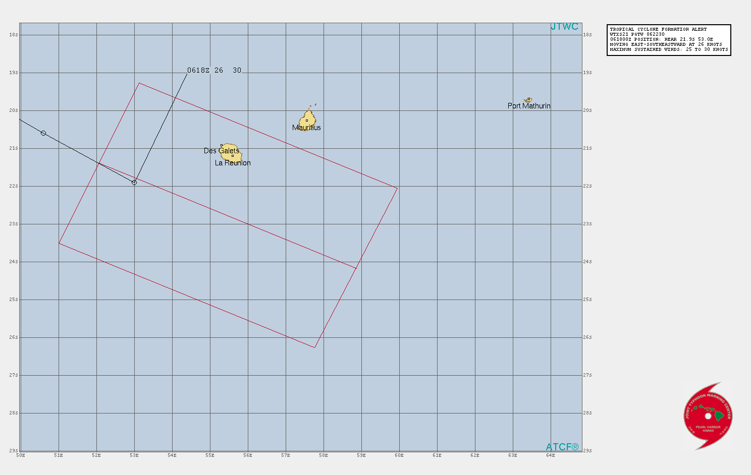
On 5 January, the Bureau of Meteorology (BOM) reported that a weak tropical low had formed within a trough over the eastern Indian Ocean, centred approximately 500 km (310 mi) northeast of the Cocos Islands.[149][150] Environmental conditions were assessed by the BOM as being broadly unfavourable for significant intensification of the low, citing in particular the strong easterly winds in the upper troposphere that were forecast to develop by 10 January.[151] The tropical low meandered gradually southwards over the following days,[152] passing well to the east of the Cocos Islands on 8–9 January, around which time the system began to accelerate towards the west-southwest.[151][153] On 9 January, the Joint Typhoon Warning Center (JTWC) reported the development of formative convective rainbands wrapping into the tropical low's centre, and determined that environmental conditions were favourable for the system to strengthen, in contrast with the BOM's assessment. The JTWC noted the presence of strong poleward upper-level outflow, low vertical wind shear values and warm sea surface temperatures of 29–30 °C (84–86 °F).[154] By 05:00 UTC on 10 January, gale-force winds had developed in the southern quadrants of the tropical low, in part due to the fast translational velocity of the system towards the west-southwest.[153] The system's minimum atmospheric pressure was estimated at 1002 hPa (29.59 inHg) at that time.[155] Then, the system exited the basin towards the Southwest Indian Ocean on 10 January, before dissipating immediately thereafter, due to unfavourable high wind shear.
On 5 February, the BoM noted that a low was beginning to form in the Gulf of Carpentaria. The next day, it developed to a tropical low, while located to the south-southeast of Angurugu. The Joint Typhoon Warning Center (JTWC) issued a tropical cyclone formation alert (TCFA); however, it was canceled on the same day. The system slowly moved to the south, before making landfall near the Northern Territory–Queensland border on the morning of 8 February. The tropical low proceeded to move inland before the BoM issued their last warning on the system later that day.
On 18 February, a weak tropical low formed from a trough in the Gulf of Carpentaria, lasting until 23 February.[156]
Storm names
Bureau of Meteorology
The Australian Bureau of Meteorology Tropical Cyclone Warning Centre (Australian TCWC) monitors all tropical cyclones that form within the Australian region, including any within the areas of responsibility of TCWC Jakarta or TCWC Port Moresby.[157] Should a tropical low reach tropical cyclone strength within the Australian TCWC's area of responsibility, it will be assigned the next name from the following naming list. The next 12 names are listed below:
|
|
TCWC Jakarta
The tropical cyclone warning centre in Jakarta monitors tropical cyclones from the Equator to 11°S, between the longitudes 90°E and 145°E. Should a tropical depression reach tropical cyclone strength within TCWC Jakarta's area of responsibility, it will be assigned the next name from the following list:[157][158]
|
|
TCWC Port Moresby
Tropical cyclones that develop between the Equator and 11°S, between the longitudes 151°E and 160°E, are assigned names by the tropical cyclone warning centre in Port Moresby, Papua New Guinea. Tropical cyclone formation in this area is rare, and no cyclones have been named in it since 2007.[159] As names are assigned in a random order, the whole list is shown below:
|
|
Season effects
| Name | Dates | Peak intensity | Areas affected | Damage (US$) |
Deaths | |||
|---|---|---|---|---|---|---|---|---|
| Category | Wind speed (km/h (mph)) |
Pressure (hPa) | ||||||
| Bongoyo | 24–30 Nov | Tropical low | 45 (30) | 1005 | Cocos Islands | None | 0 | |
| 02U | 6–12 Dec | Tropical low | 75 (45) | 991 | Sumatra, Java, Christmas Island, Western Australia, Northern Territory, South Australia | None | 0 | |
| TL | 7–11 Dec | Tropical low | 55 (35) | 997 | Western Australia, Northern Territory, South Australia | None | 0 | |
| 03U | 18–23 Dec | Tropical low | 55 (35) | 993 | Northern Territory, Kimberley | None | 0 | |
| 04U | 20–28 Dec | Tropical low | 35 (25) | 1003 | Cocos Islands | None | 0 | |
| Imogen | 1–6 Jan | Category 1 tropical cyclone | 85 (50) | 989 | Northern Territory, Far North Queensland | Unknown | 0 | [160] |
| 06U | 5–10 Jan | Tropical low | 65 (40) | 1002 | None | None | 0 | |
| Joshua | 13–17 Jan | Category 1 tropical cyclone | 75 (45) | 992 | Cocos Islands | None | 0 | |
| 08U | 15–23 Jan | Tropical low | 65 (40) | 998 | Northern Territory, Western Australia | None | 0 | |
| Kimi | 16–19 Jan | Category 2 tropical cyclone | 100 (65) | 987 | Far North Queensland | None | 0 | |
| 10U | 19–27 Jan | Tropical low | 75 (45) | 995 | Cocos Islands | None | 0 | |
| Lucas | 25 Jan – 1 Feb | Category 2 tropical cyclone | 100 (65) | 985 | Northern Territory, Far North Queensland | None | 0 | |
| 12U | 28 Jan – 5 Feb | Tropical low | 55 (35) | 992 | Northern Territory, Western Australia | None | 0 | |
| TL | 6–8 Feb | Tropical low | Not specified | 996 | Northern Territory | None | 0 | |
| TL | 18–23 Feb | Tropical low | Not specified | 1002 | Northern Territory | None | 0 | |
| Marian | 23 Feb – Present | Category 3 severe tropical cyclone | 150 (90) | 950 | Christmas Island, Cocos Islands | None | 0 | |
| Niran | 27 Feb – Present | Category 2 tropical cyclone | 110 (70) | 977 | Far North Queensland | None | 0 | |
| Season aggregates | ||||||||
| 17 systems | 24 Nov – Present | 150 (90) | 950 | 10 million | 0 | |||
See also
- List of Southern Hemisphere cyclone seasons
- Tropical cyclones in 2020, 2021
- Atlantic hurricane seasons: 2020, 2021
- Pacific hurricane seasons: 2020, 2021
- Pacific typhoon seasons: 2020, 2021
- North Indian Ocean cyclone seasons: 2020, 2021
- 2020–21 South-West Indian Ocean cyclone season
- 2020–21 South Pacific cyclone season
References
- ^ a b "Australian Tropical Cyclone Outlook for 2020 to 2021". Australian Bureau of Meteorology. 12 October 2020. Archived from the original on 12 October 2020. Retrieved 9 November 2020.
- ^ "South Pacific Tropical Cyclone Outlook for 2020 to 2021". Australian Bureau of Meteorology. 20 October 2020. Retrieved 9 November 2020.
- ^ "Tropical Cyclone Seasonal Outlook for the Northern Territory". Bureau of Meteorology. 20 October 2020. Retrieved 18 November 2020.
- ^ "Tropical Cyclone Outlook for northwest Australia". Bureau of Meteorology. 12 October 2020. Retrieved 18 November 2020.
- ^ Southwest Pacific Tropical Cyclone Outlook – October 2020 (Report). Wellington, New Zealand: National Institute of Water and Atmospheric Research. 20 October 2020. Retrieved 9 November 2020.
- ^ a b "Weekly Tropical Climate Note". Australian Bureau of Meteorology. 17 November 2020. Archived from the original on 17 November 2020. Retrieved 24 November 2020.
- ^ a b "Weekly Tropical Climate Note". Australian Bureau of Meteorology. 24 November 2020. Archived from the original on 24 November 2020. Retrieved 24 November 2020.
- ^ "Tropical Cyclone Outlook for the Western Region". Australian Bureau of Meteorology. 24 November 2020. Archived from the original on 24 November 2020. Retrieved 24 November 2020.
- ^ "South East Asia MSLP Analysis Chart (00Z)". Australian Bureau of Meteorology. 24 November 2020. Archived from the original on 24 November 2020. Retrieved 24 November 2020.
- ^ a b "Tropical Cyclone Outlook for the Western Region". Australian Bureau of Meteorology. 26 November 2020. Archived from the original on 26 November 2020. Retrieved 26 November 2020.
- ^ a b "Significant Tropical Weather Advisory for the Indian Ocean (0330Z)". Joint Typhoon Warning Center. Naval Meteorology and Oceanography Command. 26 November 2020. Archived from the original on 26 November 2020. Retrieved 26 November 2020.
- ^ "Significant Tropical Weather Advisory for the Indian Ocean (02Z)". Joint Typhoon Warning Center. Naval Meteorology and Oceanography Command. Archived from the original on 27 November 2020. Retrieved 27 November 2020.
- ^ "Tropical Cyclone Activity Bulletin for the South-West Indian Ocean (12Z)" (PDF). Météo-France La Réunion (in French). 27 November 2020. Retrieved 27 November 2020.
- ^ "Tropical Cyclone Outlook for the Western Region". Australian Bureau of Meteorology. 29 November 2020. Archived from the original on 29 November 2020. Retrieved 29 November 2020.
- ^ "Tropical Cyclone Activity Bulletin for the South-West Indian Ocean (12Z)" (PDF). Météo-France La Réunion (in French). 26 November 2020. Retrieved 29 November 2020.
- ^ "Significant Tropical Weather Advisory for the Indian Ocean (18Z)". Joint Typhoon Warning Center. Naval Meteorology and Oceanography Command. 29 November 2020. Archived from the original on 30 November 2020. Retrieved 30 November 2020.
- ^ "Tropical Cyclone Outlook for the Indian Ocean". Australian Bureau of Meteorology. 30 November 2020. Archived from the original on 30 November 2020. Retrieved 30 November 2020.
- ^ "Tropical Cyclone Bongoyo Analysis Bulletin #5 (06Z)" (PDF). Météo-France La Réunion (in French). 8 December 2020. Retrieved 8 December 2020.
- ^ "South East Asia Gradient Level Wind Analysis (00Z)". Australian Bureau of Meteorology. 25 November 2020. Archived from the original on 25 November 2020. Retrieved 27 November 2020.
- ^ "Tropical Cyclone Activity Bulletin for the South-West Indian Ocean (12Z)" (PDF). Météo-France La Réunion (in French). 30 November 2020. Retrieved 30 November 2020.
- ^ "Tropical Cyclone Outlook for the Western Region". Australian Bureau of Meteorology. 27 November 2020. Archived from the original on 27 November 2020. Retrieved 27 November 2020.
- ^ "Tropical Cyclone Outlook for the Western Region". Australian Bureau of Meteorology. 28 November 2020. Archived from the original on 28 November 2020. Retrieved 28 November 2020.
- ^ "Cocos Islands Forecast (0830Z)". Australian Bureau of Meteorology. 27 November 2020. Archived from the original on 27 November 2020. Retrieved 27 November 2020.
- ^ "Cocos Islands Airport Weather Observations". Australian Bureau of Meteorology. 27 November 2020. Archived from the original on 27 November 2020. Retrieved 27 November 2020.
- ^ "Cocos Islands Airport Daily Rainfall Observations". Australian Bureau of Meteorology. 29 November 2020. Archived from the original on 29 November 2020. Retrieved 29 November 2020.
- ^ a b "Tropical Cyclone Outlook for the Western Region". Australian Bureau of Meteorology. 6 December 2020. Archived from the original on 6 December 2020. Retrieved 6 December 2020.
- ^ "MSLP Analysis Chart for the Australian Region (06Z)". Australian Bureau of Meteorology. 6 December 2020. Archived from the original on 6 December 2020. Retrieved 6 December 2020.
- ^ a b "Tropical Cyclone Formation Alert (Invest 96S) (0530Z)". Joint Typhoon Warning Center. Naval Meteorology and Oceanography Command. 7 December 2020. Archived from the original on 7 December 2020. Retrieved 7 December 2020.
- ^ "Tropical Cyclone Outlook for the Western Region". Australian Bureau of Meteorology. 7 December 2020. Archived from the original on 7 December 2020. Retrieved 7 December 2020.
- ^ "Tropical Cyclone 03S Forecast Track Map #2 (00Z)". Joint Typhoon Warning Center. Naval Meteorology and Oceanography Command. 9 December 2020. Archived from the original on 9 December 2020. Retrieved 9 December 2020.
- ^ "Tropical Cyclone Outlook for the Western Region". Australian Bureau of Meteorology. 8 December 2020. Archived from the original on 9 December 2020. Retrieved 9 December 2020.
- ^ a b "Tropical Cyclone 03S Warning #2 (00Z)". Joint Typhoon Warning Center. Naval Meteorology and Oceanography Command. 9 December 2020. Archived from the original on 9 December 2020. Retrieved 9 December 2020.
- ^ a b "Tropical Cyclone 03S Warning #4 (12Z)". Joint Typhoon Warning Center. Naval Meteorology and Oceanography Command. 9 December 2020. Archived from the original on 9 December 2020. Retrieved 9 December 2020.
- ^ a b "Tropical Cyclone Outlook for the Western Region". Australian Bureau of Meteorology. 10 December 2020. Archived from the original on 10 December 2020. Retrieved 10 December 2020.
- ^ a b "Tropical Cyclone 03S Warning #8 (12Z)". Joint Typhoon Warning Center. Naval Meteorology and Oceanography Command. 10 December 2020. Archived from the original on 10 December 2020. Retrieved 10 December 2020.
- ^ "Tropical Cyclone 03S Warning #6 (00Z)". Joint Typhoon Warning Center. Naval Meteorology and Oceanography Command. 10 December 2020. Archived from the original on 10 December 2020. Retrieved 10 December 2020.
- ^ a b "Tropical Cyclone 03S Warning #10 (00Z)". Joint Typhoon Warning Center. Naval Meteorology and Oceanography Command. 11 December 2020. Archived from the original on 11 December 2020. Retrieved 11 December 2020.
- ^ "Severe Weather Warning for the Kimberley, Pilbara, North Interior and South Interior districts (0256Z)". Australian Bureau of Meteorology. 11 December 2020. Archived from the original on 11 December 2020. Retrieved 11 December 2020.
- ^ "Severe Weather Warning for the Kimberley, Pilbara, North Interior and South Interior districts (0414Z)". Australian Bureau of Meteorology. 11 December 2020. Archived from the original on 11 December 2020. Retrieved 11 December 2020.
- ^ "Bedout Island Weather Observations". Australian Bureau of Meteorology. 11 December 2020. Archived from the original on 11 December 202. Retrieved 11 December 2020.
- ^ "Port Hedland Airport Weather Observations". Australian Bureau of Meteorology. 11 December 2020. Archived from the original on 11 December 2020. Retrieved 11 December 2020.
- ^ "Legendre Island Weather Observations". Australian Bureau of Meteorology. 11 December 2020. Archived from the original on 11 December 2020. Retrieved 11 December 2020.
- ^ a b "MSLP Analysis Chart for the Australian Region (06Z)". Australian Bureau of Meteorology. 12 December 2020. Archived from the original on 12 December 2020. Retrieved 12 December 2020.
- ^ "Severe Weather Warning for the Pilbara, North Interior and South Interior districts (0720Z)". Australian Bureau of Meteorology. 11 December 2020. Archived from the original on 11 December 2020. Retrieved 11 December 2020.
- ^ "Severe Weather Warning for the North Interior and South Interior districts (1514Z)". Australian Bureau of Meteorology. 11 December 2020. Archived from the original on 11 December 2020. Retrieved 11 December 2020.
- ^ "Southern Interior District Forecast (0825Z)". Australian Bureau of Meteorology. 12 December 2020. Archived from the original on 12 December 2020. Retrieved 12 December 2020.
- ^ a b "Weekly Tropical Climate Note". Australian Bureau of Meteorology. 8 December 2020. Archived from the original on 8 December 2020. Retrieved 8 December 2020.
- ^ "MSLP Analysis Chart for the Australian Region (00Z)". Australian Bureau of Meteorology. 8 December 2020. Archived from the original on 8 December 2020. Retrieved 8 December 2020.
- ^ a b c "Significant Tropical Weather Advisory for the Indian Ocean (18Z)". Joint Typhoon Warning Center. Naval Meteorology and Oceanography Command. 7 December 2020. Archived from the original on 8 December 2020. Retrieved 8 December 2020.
- ^ "Kimberley District Forecast (21Z)". Australian Bureau of Meteorology. 7 December 2020. Archived from the original on 8 December 2020. Retrieved 8 December 2020.
- ^ "Severe Weather Warning for the Kimberley District (00Z)". Australian Bureau of Meteorology. 8 December 2020. Archived from the original on 8 December 2020. Retrieved 8 December 2020.
- ^ a b "Tropical Cyclone Formation Alert (Invest 99S) (2130Z)". Joint Typhoon Warning Center. Naval Meteorology and Oceanography Command. 8 December 2020. Archived from the original on 9 December 2020. Retrieved 9 December 2020.
- ^ "MSLP Analysis Chart for the Australian Region (18Z)". Australian Bureau of Meteorology. 8 December 2020. Archived from the original on 8 December 2020. Retrieved 9 December 2020.
- ^ "Severe Weather Warning for the North Interior, Kimberley and Pilbara districts (02Z)". Australian Bureau of Meteorology. 9 December 2020. Archived from the original on 9 December 2020. Retrieved 9 December 2020.
- ^ "Flood Watch #3 for the North West Pastoral District and West Coast". Australian Bureau of Meteorology. 11 December 2020. Archived from the original on 11 December 2020. Retrieved 11 December 2020.
- ^ "MSLP Analysis Chart for the Australian Region (00Z)". Australian Bureau of Meteorology. 11 December 2020. Archived from the original on 11 December 2020. Retrieved 12 December 2020.
- ^ "Adele Island Weather Observations". Australian Bureau of Meteorology. 9 December 2020. Archived from the original on 9 December 2020. Retrieved 9 December 2020.
- ^ "Bedout Island Weather Observations". Australian Bureau of Meteorology. 9 December 2020. Archived from the original on 9 December 2020. Retrieved 9 December 2020.
- ^ "Rowley Shoals Weather Observations". Australian Bureau of Meteorology. 9 December 2020. Archived from the original on 9 December 2020. Retrieved 9 December 2020.
- ^ "Port Hedland Airport Weather Observations". Australian Bureau of Meteorology. 10 December 2020. Archived from the original on 10 December 2020. Retrieved 10 December 2020.
- ^ "Warburton Airfield Weather Observations". Australian Bureau of Meteorology. 10 December 2020. Archived from the original on 10 December 2020. Retrieved 10 December 2020.
- ^ "Lombadina Airstrip Weather Observations". Australian Bureau of Meteorology. 10 December 2020. Archived from the original on 10 December 2020. Retrieved 10 December 2020.
- ^ "Giles Meteorological Office Weather Observations". Australian Bureau of Meteorology. 10 December 2020. Archived from the original on 10 December 2020. Retrieved 10 December 2020.
- ^ "Telfer Aerodrome Weather Observations". Australian Bureau of Meteorology. 10 December 2020. Archived from the original on 10 December 2020. Retrieved 10 December 2020.
- ^ "Christmas Creek Weather Observations". Australian Bureau of Meteorology. 10 December 2020. Archived from the original on 10 December 2020. Retrieved 10 December 2020.
- ^ "Broome Airport Weather Observations". Australian Bureau of Meteorology. 10 December 2020. Archived from the original on 10 December 2020. Retrieved 10 December 2020.
- ^ "Curtin Aerodrome Weather Observations". Australian Bureau of Meteorology. 10 December 2020. Archived from the original on 10 December 2020. Retrieved 10 December 2020.
- ^ "Derby Aerodrome Weather Observations". Australian Bureau of Meteorology. 10 December 2020. Archived from the original on 10 December 2020. Retrieved 10 December 2020.
- ^ "Barimunya Weather Observations". Australian Bureau of Meteorology. 10 December 2020. Archived from the original on 10 December 2020. Retrieved 10 December 2020.
- ^ "Karratha Airport Weather Observations". Australian Bureau of Meteorology. 10 December 2020. Archived from the original on 10 December 2020. Retrieved 10 December 2020.
- ^ "Marble Bar Weather Observations". Australian Bureau of Meteorology. 10 December 2020. Archived from the original on 10 December 2020. Retrieved 10 December 2020.
- ^ "Roebourne Airport Weather Observations". Australian Bureau of Meteorology. 10 December 2020. Archived from the original on 10 December 2020. Retrieved 10 December 2020.
- ^ "Mandora Weather Observations". Australian Bureau of Meteorology. 10 December 2020. Archived from the original on 10 December 2020. Retrieved 10 December 2020.
- ^ "Flood Warning #2 for the Sandy Desert (0257Z)". Australian Bureau of Meteorology. 9 December 2020. Archived from the original on 9 December 2020. Retrieved 9 December 2020.
- ^ "Flood Warning #2 for the West Kimberley District (0255Z)". Australian Bureau of Meteorology. 9 December 2020. Archived from the original on 9 December 2020. Retrieved 9 December 2020.
- ^ "Initial Flood Watch for the South Western Northern Territory (0142Z)". Australian Bureau of Meteorology. 9 December 2020. Archived from the original on 9 December 2020. Retrieved 9 December 2020.
- ^ "Initial Flood Watch for the North West Pastoral District (0242Z)". Australian Bureau of Meteorology. 9 December 2020. Archived from the original on 9 December 2020. Retrieved 9 December 2020.
- ^ a b "Weekly Tropical Climate Note". Australian Bureau of Meteorology. 15 December 2020. Archived from the original on 15 December 2020. Retrieved 20 December 2020.
- ^ "MSLP Analysis Chart for the Australian Region (06Z)". Australian Bureau of Meteorology. 17 December 2020. Archived from the original on 17 December 2020. Retrieved 20 December 2020.
- ^ a b "Tropical Cyclone Outlook for the Western Region". Australian Bureau of Meteorology. 18 December 2020. Archived from the original on 18 December 2020. Retrieved 18 December 2020.
- ^ "Tropical Cyclone Outlook for the Northern Region". Australian Bureau of Meteorology. 18 December 2020. Archived from the original on 18 December 2020. Retrieved 18 December 2020.
- ^ a b "Significant Tropical Weather Advisory for the Indian Ocean (18Z)". Joint Typhoon Warning Center. Naval Meteorology and Oceanography Command. 18 December 2020. Archived from the original on 19 December 2020. Retrieved 19 December 2020.
- ^ "Tropical Cyclone Outlook for the Western Region". Australian Bureau of Meteorology. 19 December 2020. Archived from the original on 20 December 2020. Retrieved 20 December 2020.
- ^ "MSLP Analysis Chart for the Australian Region (00Z)". Australian Bureau of Meteorology. 19 December 2020. Archived from the original on 19 December 2020. Retrieved 20 December 2020.
- ^ "Northern Area High Seas Forecast (06Z)". Australian Bureau of Meteorology. 19 December 2020. Archived from the original on 19 December 2020. Retrieved 19 December 2020.
- ^ "Significant Tropical Weather Advsiory for the Indian Ocean (18Z)". Joint Typhoon Warning Center. Naval Meteorology and Oceanography Command. 19 December 2020. Archived from the original on 20 December 2020. Retrieved 20 December 2020.
- ^ "Tropical Cyclone Outlook for the Western Region (04Z)". Australian Bureau of Meteorology. 20 December 2020. Archived from the original on 20 December 2020. Retrieved 20 December 2020.
- ^ "MSLP Analysis Chart for the Australian Region (18Z)". Australian Bureau of Meteorology. 20 December 2020. Archived from the original on 20 December 2020. Retrieved 21 December 2020.
- ^ "Tropical Cyclone Outlook for the Western Region (06Z)". Australian Bureau of Meteorology. 21 December 2020. Archived from the original on 21 December 2020. Retrieved 21 December 2020.
- ^ "Halls Creek Airport Weather Observations". Australian Bureau of Meteorology. 21 December 2020. Archived from the original on 21 December 2020. Retrieved 21 December 2020.
- ^ "Browse Island Weather Observations". Australian Bureau of Meteorology. 21 December 2020. Archived from the original on 21 December 2020. Retrieved 21 December 2020.
- ^ "Adele Island Weather Observations". Australian Bureau of Meteorology. 21 December 2020. Archived from the original on 21 December 2020. Retrieved 21 December 2020.
- ^ "Troughton Island Weather Observations". Australian Bureau of Meteorology. 21 December 2020. Archived from the original on 21 December 2020. Retrieved 21 December 2020.
- ^ "Tropical Cyclone Activity Bulletin for the South-West Indian Ocean (12Z)" (PDF). Météo-France La Réunion (in French). 20 December 2020. Retrieved 20 December 2020.
- ^ a b "Northern Area High Seas Forecast (06Z)". Australian Bureau of Meteorology. 20 December 2020. Archived from the original on 20 December 2020. Retrieved 20 December 2020.
- ^ "Tropical Cyclone Outlook for the Western Region (04Z)". Australian Bureau of Meteorology. 22 December 2020. Archived from the original on 22 December 2020. Retrieved 22 December 2020.
- ^ "Tropical Cyclone Outlook for the Western Region (04Z)". Australian Bureau of Meteorology. 20 December 2020. Archived from the original on 20 December 2020. Retrieved 20 December 2020.
- ^ "Tropical Cyclone Outlook for the Northern Region". Australian Bureau of Meteorology. 1 January 2021. Archived from the original on 1 January 2021. Retrieved 1 January 2021.
- ^ a b "Tropical Cyclone Imogen Technical Bulletin #1 (06Z)". Australian Bureau of Meteorology. 2 January 2021. Archived from the original on 2 January 2021. Retrieved 2 January 2021.
- ^ a b "Significant Tropical Weather Advisory for the Western and South Pacific Oceans (15Z)". Joint Typhoon Warning Center. Naval Meteorology and Oceanography Command. 1 January 2020. Archived from the original on 2 January 2020. Retrieved 2 January 2020.
- ^ "Tropical Cyclone Imogen Forecast Track Map #1 (00Z)". Australian Bureau of Meteorology. 2 January 2020. Archived from the original on 2 January 2020. Retrieved 2 January 2020.
- ^ "Tropical Cyclone Imogen Technical Bulletin #3 (18Z)". Australian Bureau of Meteorology. 2 January 2021. Archived from the original on 2 January 2021. Retrieved 2 January 2021.
- ^ "Tropical Cyclone Imogen Formation Alert (20Z)". Joint Typhoon Warning Center. Naval Meteorology and Oceanography Command. 2 January 2021. Archived from the original on 3 January 2021. Retrieved 3 January 2021.
- ^ "Tropical Cyclone Imogen Forecast Track Map #6 (03Z)". Australian Bureau of Meteorology. 3 January 2021. Archived from the original on 3 January 2021. Retrieved 3 January 2021.
- ^ "Tropical Cyclone Imogen Forecast Track Map #7 (06Z)". Australian Bureau of Meteorology. 3 January 2021. Archived from the original on 3 January 2021. Retrieved 3 January 2021.
- ^ "Tropical Cyclone Imogen Technical Bulletin #5 (06Z)". Australian Bureau of Meteorology. 3 January 2021. Archived from the original on 3 January 2021. Retrieved 3 January 2021.
- ^ "Tropical Cyclone Imogen Warning #1 (06Z)". Joint Typhoon Warning Center. Naval Meteorology and Oceanography Command. 3 January 2021. Archived from the original on 3 January 2021. Retrieved 3 January 2021.
- ^ a b "Tropical Cyclone Imogen Technical Bulletin #6 (12Z)". Australian Bureau of Meteorology. 3 January 2021. Archived from the original on 3 January 2021. Retrieved 3 January 2021.
- ^ "Tropical Cyclone Imogen Forecast Track Map #9 (12Z)". Australian Bureau of Meteorology. 3 January 2021. Archived from the original on 3 January 2021. Retrieved 3 January 2021.
- ^ a b "Tropical Cyclone Imogen Technical Bulletin #7 (18Z)". Australian Bureau of Meteorology. 3 January 2021. Archived from the original on 3 January 2021. Retrieved 3 January 2021.
- ^ "Tropical Cyclone Imogen Warning #2 (12Z)". Joint Typhoon Warning Center. Naval Meteorology and Oceanography Command. 3 January 2021. Archived from the original on 3 January 2021. Retrieved 3 January 2021.
- ^ "Tropical Cyclone Imogen Forecast Track Map #10 (15Z)". Australian Bureau of Meteorology. 3 January 2021. Archived from the original on 3 January 2021. Retrieved 3 January 2021.
- ^ "Normanton Airport Weather Observations". Australian Bureau of Meteorology. 3 January 2021. Archived from the original on 3 January 2021. Retrieved 3 January 2021.
- ^ "Tropical Cyclone Outlook for the Western Region". Australian Bureau of Meteorology. 13 January 2021. Archived from the original on 13 January 2021. Retrieved 13 January 2021.
- ^ "Tropical Cyclone Outlook for the Western Region, 17/01/2021". Bureau of Meteorology. Retrieved 1 February 2021.
{{cite web}}:|archive-date=requires|archive-url=(help)CS1 maint: url-status (link) - ^ "Tropical Cyclone Outlook for the Northern Region". Australian Bureau of Meteorology. 17 January 2021. Retrieved 1 January 2021.
{{cite web}}:|archive-date=requires|archive-url=(help)CS1 maint: url-status (link) - ^ "Tropical Cyclone Outlook for the Northern Region". Australian Bureau of Meteorology. 17 January 2021. Retrieved 1 January 2021.
{{cite web}}:|archive-date=requires|archive-url=(help)CS1 maint: url-status (link) - ^ "Tropical cyclone Lucas: WA braces for first cyclone of summer". PerthNow. 22 January 2021. Retrieved 30 January 2021.
{{cite web}}:|archive-date=requires|archive-url=(help)CS1 maint: url-status (link) - ^ "Tourists urged to evacuate as WA residents prepare for Cyclone Lucas". SBS News. 22 January 2021. Retrieved 30 January 2021.
{{cite web}}:|archive-date=requires|archive-url=(help)CS1 maint: url-status (link) - ^ "Weekly Tropical Climate Note". bom.gov.au. Bureau of Meteorology. January 12, 2021. Retrieved January 17, 2021.
- ^ "Tropical Cyclone Outlook for the Coral Sea". Australian Bureau of Meteorology. 16 January 2021. Archived from the original on 16 January 2021. Retrieved 16 January 2021.
- ^ "Tropical Cyclone Formation Alert Graphic". metoc.navy.mil. Joint Typhoon Warning Center. January 16, 2021. Retrieved January 18, 2021.
- ^ "Flash Tropical Cyclone Advice Number 1 (Kimi)". Australian Bureau of Meteorology. 17 January 2021. Archived from the original on 17 January 2021. Retrieved 17 January 2021.
- ^ "Tropical Cyclone Advice Number 6 (Kimi)". Australian Bureau of Meteorology. 18 January 2021. Archived from the original on 18 January 2021. Retrieved 18 January 2021.
- ^ "TROPICAL CYCLONE 11P (KIMI) WARNING NR 004". metoc.navy.mil. Joint Typhoon Warning Center. January 17, 2021. Retrieved January 17, 2021.
- ^ "TROPICAL CYCLONE TECHNICAL BULLETIN: AUSTRALIA - EASTERN REGION". bom.gov.au. Bureau of Meteorology. January 17, 2021. Retrieved January 18, 2021.
- ^ "TROPICAL CYCLONE TECHNICAL BULLETIN: AUSTRALIA - EASTERN REGION". bom.gov.au. Bureau of Meteorology. January 18, 2021. Retrieved January 18, 2021.
- ^ "TROPICAL CYCLONE 11P (KIMI) WARNING NR 007". metoc.navy.mil. Joint Typhoon Warning Center. January 18, 2021. Retrieved January 18, 2021.
- ^ "Tropical Cyclone Advice Number 15 (Kimi)". Australian Bureau of Meteorology. 18 January 2021. Archived from the original on 19 January 2021. Retrieved 18 January 2021.
- ^ "Tropical Cyclone Outlook for the Western Region". bom.gov.au. Bureau of Meteorology. January 19, 2021. Retrieved January 19, 2021.
- ^ "Tropical Cyclone Outlook for the Western Region, 23/01/2021". Bureau of Meteorology. Retrieved 1 February 2021.
{{cite web}}:|archive-date=requires|archive-url=(help)CS1 maint: url-status (link) - ^ "Tropical Cyclone Outlook for the Western Region, 27/01/2021". Bureau of Meteorology. Retrieved 1 February 2021.
{{cite web}}:|archive-date=requires|archive-url=(help)CS1 maint: url-status (link) - ^ "A NUMERO DU BULLETIN : 1/9/20202021" (PDF).
- ^ "Tropical Cyclone Outlook for the Northern Region, including the Gulf of Carpentaria". bom.gov.au. Bureau of Meteorology. January 25, 2021. Retrieved January 25, 2021.
- ^ "Tropical Cyclone Outlook for the Northern Region, including the Gulf of Carpentaria". bom.gov.au. Bureau of Meteorology. January 27, 2021. Retrieved January 27, 2021.
- ^ "Tropical Cyclone Outlook for the Coral Sea". Australian Bureau of Meteorology. 30 January 2021. Archived from the original on 30 January 2021. Retrieved 30 January 2021.
- ^ "Tropical Cyclone Outlook for the Coral Sea". Australian Bureau of Meteorology. 1 February 2021. Archived from the original on 1 February 2021. Retrieved 1 February 2021.
- ^ "Tropical Cyclone Outlook for the Western Region". Bureau of Meteorology. 28 January 2021.
{{cite web}}: CS1 maint: url-status (link) - ^ "Tropical Cyclone Advice Number 5". Bureau of Meteorology. 30 January 2021.
{{cite web}}: CS1 maint: url-status (link) - ^ "Tropical Cyclone Outlook for the Western Region". Australian Bureau of Meteorology. 5 February 2021. Archived from the original on 5 February 2021. Retrieved 5 February 2021.
- ^ "Tropical Cyclone Outlook for the Western Region". Bureau of Meteorology. 23 February 2021.
{{cite web}}: CS1 maint: url-status (link) - ^ "TROPICAL CYCLONE FORMATION ALERT (INVEST 98S)". Joint Typhoon Warning Center. 25 February 2021. Archived from the original on 25 February 2021. Retrieved 25 February 2021.
- ^ "TROPICAL CYCLONE 22S (TWENTYTWO) WARNING NR 001". Joint Typhoon Warning Center. 26 February 2021. Archived from the original on 26 February 2021. Retrieved 26 February 2021.
- ^ "TROPICAL CYCLONE TECHNICAL BULLETIN: AUSTRALIA - WESTERN REGION". Bureau of Meteorology. February 26, 2021. Retrieved February 26, 2021.
- ^ "Tropical Cyclone Marian (22S) Warning NR 006". Joint Typhoon Warning Center. February 28, 2021. Retrieved February 28, 2021.
{{cite web}}: CS1 maint: url-status (link) - ^ "Cyclone Marian Technical Bulletin (06Z)". Australian Bureau of Meteorology. 1 March 2021. Archived from the original on 1 March 2021. Retrieved 1 March 2021.
- ^ "Tropical Cyclone Activity Bulletin for the South-West Indian Ocean (12Z)" (PDF). Météo-France La Réunion (in French). 28 February 2021. Retrieved 1 March 2021.
{{cite web}}: CS1 maint: url-status (link) - ^ "Tropical Cyclone Outlook for the Coral Sea". Bureau of Meteorology. 23 February 2021.
{{cite web}}: CS1 maint: url-status (link) - ^ "Tropical Cyclone Outlook for the Western Region". Australian Bureau of Meteorology. 5 January 2021. Archived from the original on 5 January 2021. Retrieved 5 January 2021.
- ^ "South East Asia MSLP Analysis Chart (00Z)". Australian Bureau of Meteorology. 5 January 2021. Archived from the original on 5 January 2021. Retrieved 5 January 2021.
- ^ a b "Tropical Cyclone Outlook for the Western Region". Australian Bureau of Meteorology. 9 January 2021. Archived from the original on 9 January 2021. Retrieved 9 January 2021.
- ^ "MSLP Analysis Chart for the Australian Region (12Z)". Australian Bureau of Meteorology. 7 January 2021. Archived from the original on 7 January 2021. Retrieved 10 January 2021.
- ^ a b "Tropical Cyclone Outlook for the Western Region". Australian Bureau of Meteorology. 10 January 2021. Archived from the original on 10 January 2021. Retrieved 10 January 2021.
- ^ "Significant Tropical Weather Advisory for the Indian Ocean (18Z)". Joint Typhoon Warning Center. 9 January 2021. Archived from the original on 10 January 2021. Retrieved 10 January 2021.
- ^ "Western Area High Seas Forecast (06Z)". Australian Bureau of Meteorology. 10 January 2021. Archived from the original on 10 January 2021. Retrieved 10 January 2021.
- ^ "Tropical Cyclone Outlook for the Northern Region, including the Gulf of Carpentaria". bom.gov.au. Bureau of Meteorology. February 18, 2021. Retrieved February 18, 2021.
- ^ a b "Regional Association V -Tropical Cyclone Operational Plan for the South Pacific and South-East Indian Ocean". World Meteorological Organization. 2020. p. 15. Retrieved 21 January 2021.
- ^ "Cyclone Names". Indonesian Agency for Meteorology, Climatology and Geophysics. Archived from the original on 24 November 2020. Retrieved 24 November 2020.
- ^ Gary Padgett (2008). "Monthly Global Tropical Cyclone Summary October". Australian Severe Weather. Retrieved 2013-07-01.
- ^ "Global Catastrophe Recap 2021" (PDF). AON Benfield. Retrieved February 14, 2021.
External links
- Australian Bureau of Meteorology
- Joint Typhoon Warning Center
- Tropical Cyclone Warning Center Jakarta (in Indonesian)
- Papua New Guinea National Weather Service
Tropical cyclones of the 2020–21 Australian region cyclone season | ||
|---|---|---|
| ||