Flyer22 Frozen (talk | contribs) m Reverted 4 edits by 46.99.52.210 identified as test/vandalism using STiki |
Viewfinder (talk | contribs) Claim that Gjeravica is the highest mountain in Kosovo are inconsistent with local topographic maps |
||
| Line 24: | Line 24: | ||
| type = |
| type = |
||
}} |
}} |
||
'''Đeravica''' or '''Gjeravica''' ({{lang-sq|Gjeravica}}; {{lang-sr-cyr|Ђеравица}}) is the second highest mountain peak in the [[Prokletije]] [[mountain range]] and the [[Dinaric Alps]] chain, after [[Maja Jezercë]]. It is the highest mountain in [[Kosovo]]{{efn|name=status}}, and the highest mountain of [[Serbia]], according to the [[Status of Kosovo|view held by the government of Serbia that Kosovo is part of Serbia]]. It has an elevation of {{convert|2656|m|ft|0|abbr=on}} above sea level.<ref name="CIA-Kosovo-2014" /><ref name="CIA-1999" /><ref name="ser-gov" /><ref name="NTOoS" /> Đeravica is located in the western part of Kosovo, in the municipality of [[Deçan]].<ref>{{cite web | url=http://www.logincee.org/file/22459/library | title=Local Development Strategy | publisher=Municipality of Decan | date=February 2009 | accessdate=5 April 2015 | pages=23}}</ref> |
'''Đeravica''' or '''Gjeravica''' ({{lang-sq|Gjeravica}}; {{lang-sr-cyr|Ђеравица}}) is the second highest mountain peak in the [[Prokletije]] [[mountain range]] and the [[Dinaric Alps]] chain, after [[Maja Jezercë]]. It is officially the highest mountain in [[Kosovo]]{{efn|name=status}}, and the highest mountain of [[Serbia]], according to the [[Status of Kosovo|view held by the government of Serbia that Kosovo is part of Serbia]]. It has an elevation of {{convert|2656|m|ft|0|abbr=on}} above sea level.<ref name="CIA-Kosovo-2014" /><ref name="CIA-1999" /><ref name="ser-gov" /><ref name="NTOoS" /> Đeravica is located in the western part of Kosovo, in the municipality of [[Deçan]].<ref>{{cite web | url=http://www.logincee.org/file/22459/library | title=Local Development Strategy | publisher=Municipality of Decan | date=February 2009 | accessdate=5 April 2015 | pages=23}}</ref> The official claim is, however, inconsistent with local topographic maps, which show higher summits in the Great Rudoka range in the south of Kosovo. |
||
==National importance== |
==National importance== |
||
Đeravica is the highest mountain of Kosovo.<ref name="CIA-Kosovo-2014">{{cite web | url=https://www.cia.gov/library/publications/the-world-factbook/geos/print/country/countrypdf_kv.pdf | title=CIA World Factbook 2014: Kosovo | publisher=[[Central Intelligence Agency]] | date=2014 | accessdate=5 April 2015}}</ref> Between 1992 and 2006, it was the highest mountain peak of the [[Federal Republic of Yugoslavia]], and then of the [[State Union of Serbia and Montenegro]].<ref name="CIA-1999">{{cite web | url=http://www.gutenberg.org/cache/epub/27676/pg27676.html | title=CIA World Factbook 1999 | publisher=[[Central Intelligence Agency]] | date=1999 | accessdate=5 April 2015}}</ref> Up until the [[2008 Kosovo declaration of independence]], Đeravica was indisputably the highest mountain of Serbia. The [[Government of Serbia]] ([[recognition of Kosovo|supported by some other states]]) still considers Kosovo to be part of Serbia,<ref name="ser-gov-kosmet">{{cite web | url=http://www.srbija.gov.rs/pages/article.php?id=20619 | title=Facts about Serbia: Kosovo-Metohija | publisher=[[Government of Serbia]] | accessdate=5 April 2015}}</ref> and according to this view, Đeravica is still the highest mountain of Serbia.<ref name="ser-gov">{{cite web | url=http://www.srbija.gov.rs/pages/article.php?id=30 | title=Facts about Serbia: Position, relief and climate | publisher=[[Government of Serbia]] | accessdate=5 April 2015}}</ref><ref name="NTOoS">{{cite web | url=http://www.serbia.travel/about-serbia/facts/ | title=Facts about Serbia | publisher=National Tourism Organisation of Serbia | date=2015 | accessdate=5 April 2015}}</ref> |
Đeravica is claimed to be the highest mountain of Kosovo.<ref name="CIA-Kosovo-2014">{{cite web | url=https://www.cia.gov/library/publications/the-world-factbook/geos/print/country/countrypdf_kv.pdf | title=CIA World Factbook 2014: Kosovo | publisher=[[Central Intelligence Agency]] | date=2014 | accessdate=5 April 2015}}</ref> Between 1992 and 2006, it was the highest mountain peak of the [[Federal Republic of Yugoslavia]], and then of the [[State Union of Serbia and Montenegro]].<ref name="CIA-1999">{{cite web | url=http://www.gutenberg.org/cache/epub/27676/pg27676.html | title=CIA World Factbook 1999 | publisher=[[Central Intelligence Agency]] | date=1999 | accessdate=5 April 2015}}</ref> Up until the [[2008 Kosovo declaration of independence]], Đeravica was indisputably the highest mountain of Serbia. The [[Government of Serbia]] ([[recognition of Kosovo|supported by some other states]]) still considers Kosovo to be part of Serbia,<ref name="ser-gov-kosmet">{{cite web | url=http://www.srbija.gov.rs/pages/article.php?id=20619 | title=Facts about Serbia: Kosovo-Metohija | publisher=[[Government of Serbia]] | accessdate=5 April 2015}}</ref> and according to this view, Đeravica is still the highest mountain of Serbia.<ref name="ser-gov">{{cite web | url=http://www.srbija.gov.rs/pages/article.php?id=30 | title=Facts about Serbia: Position, relief and climate | publisher=[[Government of Serbia]] | accessdate=5 April 2015}}</ref><ref name="NTOoS">{{cite web | url=http://www.serbia.travel/about-serbia/facts/ | title=Facts about Serbia | publisher=National Tourism Organisation of Serbia | date=2015 | accessdate=5 April 2015}}</ref> |
||
==Features== |
==Features== |
||
Revision as of 09:25, 21 September 2015
| Đeravica | |
|---|---|
| Gjeravica | |
 Đeravica | |
| Highest point | |
| Elevation | 2,656 m (8,714 ft)[1][2][3][4] |
| Prominence | 1,018 m (3,340 ft)[5] |
| Isolation | 28.71 km (17.84 mi) |
| Listing | Country high point |
| Naming | |
| Pronunciation | pronunciation Serbo-Croatian pronunciation: [dʑɛraʋitsa] Albanian pronunciation: [ɟɛɾavitsa] |
| Geography | |
 Đeravica Location of Đeravica in Kosovo | |
| Location | near Deçan, Kosovo[a] |
| Parent range | Prokletije |
Đeravica or Gjeravica (Albanian: Gjeravica; Serbian Cyrillic: Ђеравица) is the second highest mountain peak in the Prokletije mountain range and the Dinaric Alps chain, after Maja Jezercë. It is officially the highest mountain in Kosovo[a], and the highest mountain of Serbia, according to the view held by the government of Serbia that Kosovo is part of Serbia. It has an elevation of 2,656 m (8,714 ft) above sea level.[1][2][3][4] Đeravica is located in the western part of Kosovo, in the municipality of Deçan.[6] The official claim is, however, inconsistent with local topographic maps, which show higher summits in the Great Rudoka range in the south of Kosovo.
National importance
Đeravica is claimed to be the highest mountain of Kosovo.[1] Between 1992 and 2006, it was the highest mountain peak of the Federal Republic of Yugoslavia, and then of the State Union of Serbia and Montenegro.[2] Up until the 2008 Kosovo declaration of independence, Đeravica was indisputably the highest mountain of Serbia. The Government of Serbia (supported by some other states) still considers Kosovo to be part of Serbia,[7] and according to this view, Đeravica is still the highest mountain of Serbia.[3][4]
Features
It is somewhat different from the rest of the Prokletije mountains because of the lack of a stony, limestone texture the mountains in Prokletije have.[citation needed] Many large and small glacial lakes can be found near the summit. The largest of the lakes is Đeravica Lake which is just under the summit and is the origin of the Erenik river.
Đeravica and the Prokletije are mostly known for the growth of Chestnuts.[citation needed] There are also wild strawberries growing in Đeravica during the summer.[citation needed]
Geography
Nearby settlements
Nearby Peaks
- Kumulore
- Tropojske Pločice
- Guri i Gjate
- Maja e Ram Arućit
- Ljogi i Prelš
Cliffs
- Biga Tamas
- Krši i Ćenit
- Kumulore
- Krši i Zi
- Guri i Mal
- Gurt e Ljove
- Brehov
- Minarja
Nearby Springs
- Kroni Tedel
- Kroni Gusija
- Kroni i Lizit
- Kroni i Nuses
- Gura e Hasanags
- Kroni i Metes
- Gura e Mir
- Kroni i Rasave
- Kroni i Smajlit
- Gura i Ćuršis
- Gura Hođs
- Kroni i Mir
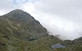
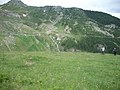
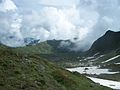
Gallery
-
 Glacial lake Gjeravica Lake near the summit
 -
 Gjeravica in snow
 -
 Glacial lakes in Gjeravica.
 -
 Viewpoint from Gjeravica
 -
 Gjeravica is a frequented Hiking place.
 -
 Another Viewpoint from Gjeravica
 -
 Erenik river near the springs in Gjeravica
 -
 Picture of the lakes


Notes and references
Notes:
References:
- ^ a b c "CIA World Factbook 2014: Kosovo" (PDF). Central Intelligence Agency. 2014. Retrieved 5 April 2015.
- ^ a b c "CIA World Factbook 1999". Central Intelligence Agency. 1999. Retrieved 5 April 2015.
- ^ a b c "Facts about Serbia: Position, relief and climate". Government of Serbia. Retrieved 5 April 2015.
- ^ a b c "Facts about Serbia". National Tourism Organisation of Serbia. 2015. Retrieved 5 April 2015.
- ^ "Daravica, Kosovo". Peakbagger.com. Retrieved 5 April 2015.
- ^ "Local Development Strategy". Municipality of Decan. February 2009. p. 23. Retrieved 5 April 2015.
- ^ "Facts about Serbia: Kosovo-Metohija". Government of Serbia. Retrieved 5 April 2015.