The Blue Marble, a photograph of the planet Earth made on 7 December 1972 by the crew of the Apollo 17 spacecraft.
The world is the totality of entities, the whole of reality, or everything that exists. The nature of the world has been conceptualized differently in different fields. Some conceptions see the world as unique while others talk of a "plurality of worlds". Some treat the world as one simple object while others analyze the world as a complex made up of parts.
In scientific cosmology, the world or universe is commonly defined as "[t]he totality of all space and time; all that is, has been, and will be". Theories of modality talk of possible worlds as complete and consistent ways how things could have been. Phenomenology, starting from the horizon of co-given objects present in the periphery of every experience, defines the world as the biggest horizon or the "horizon of all horizons". In philosophy of mind, the world is contrasted with the mind as that which is represented by the mind. Theology conceptualizes the world in relation to God, for example, as God's creation, as identical to God or as the two being interdependent. In religions, there is a tendency to downgrade the material or sensory world in favor of a spiritual world to be sought through religious practice. A comprehensive representation of the world and our place in it, as is found in religions, is known as a worldview. Cosmogony is the field that studies the origin or creation of the world while eschatology refers to the science or doctrine of the last things or of the end of the world.
Earth's crust is its thick outer shell of rock, referring to less than one percent of the planet's radius and volume. It is the top component of the lithosphere, a division of Earth's layers that includes the crust and the upper part of the mantle. The lithosphere is broken into tectonic plates whose motion allows heat to escape the interior of Earth into space.
The crust lies on top of the mantle, a configuration that is stable because the upper mantle is made of peridotite and is therefore significantly denser than the crust. The boundary between the crust and mantle is conventionally placed at the Mohorovičić discontinuity, a boundary defined by a contrast in seismic velocity. (Full article...)
A time zone is an area which observes a uniform standard time for legal, commercial and social purposes. Time zones tend to follow the boundaries between countries and their subdivisions instead of strictly following longitude, because it is convenient for areas in frequent communication to keep the same time.
Each time zone is defined by a standard offset from Coordinated Universal Time (UTC). The offsets range from UTC−12:00 to UTC+14:00, and are usually a whole number of hours, but a few zones are offset by an additional 30 or 45 minutes, such as in India and Nepal. Some areas in a time zone may use a different offset for part of the year, typically one hour ahead during spring and summer, a practice known as daylight saving time (DST). (Full article...)
The IBAN consists of up to 34 alphanumeric characters comprising a country code; two check digits; and a number that includes the domestic bank account number, branch identifier, and potential routing information. The check digits enable a check of the bank account number to confirm its integrity before submitting a transaction. (Full article...)
The association shares the World Bank's mission of reducing poverty and aims to provide affordable development financing to countries whose credit risk is so prohibitive that they cannot afford to borrow commercially or from the Bank's other programs. The IDA's stated aim is to assist the poorest nations in growing more quickly, equitably, and sustainably to reduce poverty. The IDA is the single largest provider of funds to economic and human development projects in the world's poorest nations. From 2000 to 2010, it financed projects which recruited and trained 3 million teachers, immunized 310 million children, funded $792 million in loans to 120,000 small and medium enterprises, built or restored 118,000 kilometers of paved roads, built or restored 1,600 bridges, and expanded access to improved water to 113 million people and improved sanitation facilities to 5.8 million people. The IDA has issued a total US$238 billion in loans and grants since its launch in 1960. Thirty-six of the association's borrowing countries have graduated from their eligibility for its concessional lending. However, nine of these countries have relapsed and have not re-graduated. (Full article...)
Image 7
The net worth of the world's billionaires increased from less than US$1 trillion in 2000 to over $7 trillion in 2015.
The World's Billionaires is an annual ranking of people who are billionaires, i.e., they are considered to have a net worth of US$1 billion or more, by the American business magazine Forbes. The list was first published in March 1987. The total net worth of each individual on the list is estimated and is cited in United States dollars, based on their documented assets and accounting for debt and other factors. Royalty and dictators whose wealth comes from their positions are excluded from these lists. This ranking is an index of the wealthiest documented individuals, excluding any ranking of those with wealth that is not able to be completely ascertained.
In 2018, Amazon founder Jeff Bezos was ranked at the top for the first time and became the first centibillionaire included in the ranking, surpassing Microsoft founder Bill Gates, who had topped the list 18 of the previous 24 years. In 2022, after topping the list for four years, Bezos was surpassed by Elon Musk. In 2023, Musk was in turn surpassed by French businessman Bernard Arnault, after topping the list for just a year. Arnault became the first French person to top the list. (Full article...)
The following are images from various world-related articles on Wikipedia.
Image 1Change in average surface air temperature and drivers for that change. Human activity has caused increased temperatures, with natural forces adding some variability. (from Earth)
Image 19A reconstruction of human history based on fossil data. (from History of Earth)
Image 20An artist's impression of the Archean, the eon after Earth's formation, featuring round stromatolites, which are early oxygen-producing forms of life from billions of years ago. After the Late Heavy Bombardment, Earth's crust had cooled, its water-rich barren surface is marked by continents and volcanoes, with the Moon still orbiting Earth half as far as it is today, appearing 2.8 times larger and producing strong tides. (from Earth)
Image 28An animation of the changing density of productive vegetation on land (low in brown; heavy in dark green) and phytoplankton at the ocean surface (low in purple; high in yellow) (from Earth)
Image 35Pangaea was a supercontinent that existed from about 300 to 180 Ma. The outlines of the modern continents and other landmasses are indicated on this map. (from History of Earth)
Image 37Geologic map of North America, color-coded by age. From most recent to oldest, age is indicated by yellow, green, blue, and red. The reds and pinks indicate rock from the Archean.
Image 48Earth's history with time-spans of the eons to scale (from History of Earth)
Image 49Japanese depiction of a Portuguese carrack. European maritime innovations led to proto-globalization.
Image 50Artist's impression of Earth during the later Archean, the largely cooled planetary crust and water-rich barren surface, marked by volcanoes and continents, features already roundmicrobialites. The Moon, still orbiting Earth much closer than today and still dominating Earth's sky, produced strong tides. (from History of Earth)
Image 51Artist's rendition of an oxinated fully-frozen Snowball Earth with no remaining liquid surface water. (from History of Earth)
Image 53Tiktaalik, a fish with limb-like fins and a predecessor of tetrapods. Reconstruction from fossils about 375 million years old. (from History of Earth)
Image 54Conjectured illustration of the scorched Earth after the Sun has entered the red giant phase, about 5–7 billion years from now (from Earth)
Image 65Earth's axial tilt causing different angles of seasonal illumination at different orbital positions around the Sun (from Earth)
Image 66Earth's night-side upper atmosphere appearing from the bottom as bands of afterglow illuminating the troposphere in orange with silhouettes of clouds, and the stratosphere in white and blue. Next the mesosphere (pink area) extends to the orange and faintly green line of the lowest airglow, at about one hundred kilometers at the edge of space and the lower edge of the thermosphere (invisible). Continuing with green and red bands of aurorae stretching over several hundred kilometers. (from Earth)
Image 69Trilobites first appeared during the Cambrian period and were among the most widespread and diverse groups of Paleozoic organisms. (from History of Earth)
Image 73Artist's impression of a Hadean landscape with the relatively newly formed Moon still looming closely over Earth and both bodies sustaining strong volcanism. (from History of Earth)
Image 75Earth's western hemisphere showing topography relative to Earth's center instead of to mean sea level, as in common topographic maps (from Earth)
Image 80Exaggerated illustration of Earth's elliptical orbit around the Sun, marking that the orbital extreme points (apoapsis and periapsis) are not the same as the four seasonal extreme points, the equinox and solstice (from Earth)
Image 81The replicator in virtually all known life is deoxyribonucleic acid. DNA is far more complex than the original replicator and its replication systems are highly elaborate. (from History of Earth)
Image 83A view of Earth with its global ocean and cloud cover, which dominate Earth's surface and hydrosphere; at Earth's polar regions, its hydrosphere forms larger areas of ice cover. (from Earth)
Image 84Artist's impression of the enormous collision that probably formed the Moon (from History of Earth)
Image 86A 2012 artistic impression of the early Solar System's protoplanetary disk from which Earth and other Solar System bodies were formed (from Earth)
The GDP in Osaka–Kobe is $681 billion as measured by PPP , making it one of the world's most productive regions, a match with Paris and London. MasterCard Worldwide reported that Osaka is the 19th ranking city of the world's leading global cities and has an instrumental role in driving the global economy. If Keihanshin were a country, it would be the 16th-largest economy in the world, with a GDP of nearly $953.9 billion in 2012. (Full article...)
... that a large basin on Neptune's moon Triton may have once been filled with liquid water cryolava, similar to how liquid silicates fill lava lakes on Earth?
... that homes in urban areas must have earthquake insurance before being connected to electricity in Turkey?
... that the flag of Sark represented the last feudal state in the Western world, and is flown over the British Ministry of Justice every 6 August to commemorate the granting of the fief?
From the 17th century, the Omani Sultanate was an empire, vying with the Portuguese and British empires for influence in the Persian Gulf and the Indian Ocean. At its peak in the 19th century, Omani influence and control extended across the Strait of Hormuz to Iran and Pakistan, and as far south as Zanzibar. In the 20th century, the sultanate came under the influence of the United Kingdom. For over 300 years, the relations built between the two empires were based on mutual benefit. The UK recognized Oman's geographical importance as a trading hub that secured British trading-lanes in the Persian Gulf and Indian Ocean and protected London's interests in the Indian sub-continent. Oman is an absolute monarchy led by a sultan, with power passed down through the male line. Qaboos bin Said was the Sultan from 1970 until his death on 10 January 2020. Qaboos, who died childless, had named his cousin, Haitham bin Tariq, as his successor in a letter, and the ruling family confirmed him as the new Sultan of Oman. (Full article...)
The 12 Treasures of Spain (Spanish: 12 Tesoros de España) was a project that selected the purported "Twelve Treasures of the Kingdom of Spain". The contest was conducted by broadcasters Antena 3 and COPE. The final results were announced on 31 December 2007. Nine architectural monuments, two natural monuments and a monument pictorial were chosen. (Full article...)
Within each classification of reserve there may be a variation of IUCN categories Australia is a signatory to the Convention of Biological Diversity and as such has obligations to report the status of its National Reserve System.IUCN provides on its website a prescription for activities consistent with the categorisation system. Changes made to the Nature Conservation Act 2002 in 2014 permit timber harvesting. These changes made in addition to the already established right to access minerals means that many of the IUCN categorisations assigned to individual reserves in Tasmania are no longer fit for purpose. In addition many reserves have had their reserve status downgraded from a class excluding timber harvesting and mineral extraction to ones where these activities are now permitted. This mis-application of the IUCN protected area categories needs to be remedied or the reserves protected land class under the Nature Conservation Act 2002 should be adjusted to reflect its currently assigned IUCN category. (Full article...)
Image 5
Protected areas of Canada consist of approximately 12.1 percent of the nation's landmass and freshwater are considered conservation areas, including 11.4 percent designated as protected areas. Approximately 13.8 percent of Canada's territorial waters are conserved, including 8.9 percent designated as protected areas. Terrestrial areas conserved have increased by 65 percent in the 21st century, while marine areas conserved have increased by more than 3,800 percent.
Conservation and protected areas have different mandates depending on the organization which manages them, with some areas having a greater focus on ecological integrity, historical preservation, public usage, scientific research, or a combination of usages. Some areas such as the Polar Bear Pass, are co-managed and overseen by government and local indigenous agencies. (Full article...)
The protected areas of Michigan come in an array of different types and levels of protection. Michigan has five units of the National Park Service system. There are 14 federal wilderness areas; the majority of these are also tribal-designated wildernesses. It has one of the largest state forest systems as well having four national forests. The state maintains a large state park system and there are also regional parks, and county, township and city parks. Still other parks on land and in the Great Lakes are maintained by other governmental bodies. Private protected areas also exist in the state, mainly lands owned by land conservancies. (Full article...)
Image 10
Kentucky's system of 44 state parks has been referred to as "the nation's finest" and experiences more repeat business annually than those of any other U.S. state. The state's diverse geography provides a variety of environments to experience. From mountain lakes to expansive caves to forests teeming with wildlife, park-goers have their choice of attractions, and they are all within a day's drive of each other.
Unless otherwise specified, data in the following lists are taken from Kentucky State Parks by Bill Bailey. (Full article...)
West Matukituki Valley and the Matukituki River seen from Cascade Saddle in Mount Aspiring National Park Protected areas of New Zealand are areas that are in some way protected to preserve their environmental, scientific, scenic, historical, cultural or recreational value. There are about 10,000 protected areas, covering about a third of the country. The method and aims of protection vary according to the importance of the resource and whether it is publicly or privately owned.
About 17 percent of the mainland of Norway is protected. Of this, ca. 8.3 percent is national parks, 1.3 percent is nature reserves and 4.7 percent otherwise protected. (Full article...)
Estonia has five national parks, 167 nature reserves and 152 landscape conservation areas. In addition, there are 116 (118) protected areas with an old (Soviet-era) protection regulation and 537 parks. In total, 18.1% of Estonia are protected nature areas, with Lääne County having the highest percentage (32%) and Põlva County the lowest percentage of protected areas, about 9%. (Full article...)
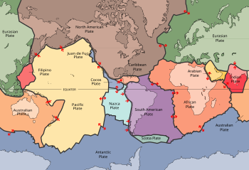
Image 1A plate tectonics map with volcano locations indicated with red circles
Image 2Only a few of the largest large igneous provinces appear (coloured dark purple) on this geological map, which depicts crustal geologic provinces as seen in seismic refraction data


 Change in average surface air temperature and drivers for that change. Human activity has caused increased temperatures, with natural forces adding some variability. (from Earth)
 Satellite time lapse imagery of Earth's rotation showing axis tilt (from Earth)
 A computer-generated image mapping the prevalence of artificial satellites and space debris around Earth in geosynchronous and low Earth orbit (from Earth)
 Cross-section through a liposome (from History of Earth)
 Shanghai. China urbanized rapidly in the 21st century.
 A banded iron formation from the 3.15 Ga Moodies Group, Barberton Greenstone Belt, South Africa. Red layers represent the times when oxygen was available; gray layers were formed in anoxic circumstances. (from History of Earth)
 Chloroplasts in the cells of a moss (from History of Earth)
 A reconstruction of Pannotia (550 Ma). (from History of Earth)
 Olmec colossal head, now at the Museo de Antropología de Xalapa
 First airplane, the Wright Flyer, flew on 17 December 1903.
 Artist's conception of Devonian flora (from History of Earth)
 Chennakesava Temple, Belur, India
 Florence, birthplace of the Italian Renaissance
 Pale orange dot, an artist's impression of Early Earth, featuring its tinted orange methane-rich early atmosphere (from Earth)
 "Lucy", the first Australopithecus afarensis skeleton found, was only 1.06 m (3 ft 6 in) tall.
 A reconstruction of human history based on fossil data. (from History of Earth)
 An artist's impression of the Archean, the eon after Earth's formation, featuring round stromatolites, which are early oxygen-producing forms of life from billions of years ago. After the Late Heavy Bombardment, Earth's crust had cooled, its water-rich barren surface is marked by continents and volcanoes, with the Moon still orbiting Earth half as far as it is today, appearing 2.8 times larger and producing strong tides. (from Earth)
 Battle during the 1281 Mongol invasion of Japan

 View of Earth from the Moon by the Lunar Reconnaissance Orbiter (from Earth)
 Persepolis, Achaemenid Empire, 6th century BCE
 Artist's conception of Hadean Eon Earth, when it was much hotter and inhospitable to all forms of life. (from History of Earth)
 Graph showing range of estimated partial pressure of atmospheric oxygen through geologic time (from History of Earth)
 An animation of the changing density of productive vegetation on land (low in brown; heavy in dark green) and phytoplankton at the ocean surface (low in purple; high in yellow) (from Earth)
 Ajloun Castle, Jordan
 Fall of the Berlin Wall, 1989
 13th-century French historiated initial with the three classes of medieval society: those who prayed (the clergy), those who fought (the knights), and those who worked (the peasantry) (from Human history)
 Pangaea was a supercontinent that existed from about 300 to 180 Ma. The outlines of the modern continents and other landmasses are indicated on this map. (from History of Earth)
 Lithified stromatolites on the shores of Lake Thetis, Western Australia. Archean stromatolites are the first direct fossil traces of life on Earth. (from History of Earth)
 Geologic map of North America, color-coded by age. From most recent to oldest, age is indicated by yellow, green, blue, and red. The reds and pinks indicate rock from the Archean.
 Standing Buddha from Gandhara, 2nd century CE
 Taj Mahal, Mughal Empire, India
 A 580 million year old fossil of Spriggina floundensi, an animal from the Ediacaran period. Such life forms could have been ancestors to the many new forms that originated in the Cambrian Explosion. (from History of Earth)
 Tracy Caldwell Dyson, a NASA astronaut, observing Earth from the Cupola module at the International Space Station on 11 September 2010 (from Earth)
 A schematic view of Earth's magnetosphere with solar wind flowing from left to right (from Earth)
 An artist's rendering of a protoplanetary disk (from History of Earth)
 A map of heat flow from Earth's interior to the surface of Earth's crust, mostly along the oceanic ridges (from Earth)
 A composite image of artificial light emissions at night on a map of Earth (from Earth)
 A view of Earth with different layers of its atmosphere visible: the troposphere with its clouds casting shadows, a band of stratospheric blue sky at the horizon, and a line of green airglow of the lower thermosphere around an altitude of 100 km, at the edge of space (from Earth)
 Benin Bronze head from Nigeria
 Earth's history with time-spans of the eons to scale (from History of Earth)
 Japanese depiction of a Portuguese carrack. European maritime innovations led to proto-globalization.
 Artist's rendition of an oxinated fully-frozen Snowball Earth with no remaining liquid surface water. (from History of Earth)
 Yggdrasil, an attempt to reconstruct the Norse world tree which connects the heavens, the world, and the underworld. (from World)
 Tiktaalik, a fish with limb-like fins and a predecessor of tetrapods. Reconstruction from fossils about 375 million years old. (from History of Earth)

 Great Mosque of Kairouan, Tunisia, founded 670 CE
 An artist's impression of ice age Earth at glacial maximum. (from History of Earth)
 COVID-19 pandemic, 2020 (from Human history)
 Angkor Wat temple complex, Cambodia, early 12th century
 Peopling of the world, the Southern Dispersal scenario
 Great Pyramids of Giza, Egypt
 Earth's axial tilt causing different angles of seasonal illumination at different orbital positions around the Sun (from Earth)
 Earth's night-side upper atmosphere appearing from the bottom as bands of afterglow illuminating the troposphere in orange with silhouettes of clouds, and the stratosphere in white and blue. Next the mesosphere (pink area) extends to the orange and faintly green line of the lowest airglow, at about one hundred kilometers at the edge of space and the lower edge of the thermosphere (invisible). Continuing with green and red bands of aurorae stretching over several hundred kilometers. (from Earth)
 Vitruvian Man by Leonardo da Vinci epitomizes the advances in art and science seen during the Renaissance. (from History of Earth)
 Trilobites first appeared during the Cambrian period and were among the most widespread and diverse groups of Paleozoic organisms. (from History of Earth)
 Dinosaurs were the dominant terrestrial vertebrates throughout most of the Mesozoic (from History of Earth)
 Empires of the world in 1898
 A composite image of Earth, with its different types of surface discernible: Earth's surface dominating Ocean (blue), Africa with lush (green) to dry (brown) land and Earth's polar ice in the form of Antarctic sea ice (grey) covering the Antarctic or Southern Ocean and the Antarctic ice sheet (white) covering Antarctica. (from Earth)
 Artist's impression of a Hadean landscape with the relatively newly formed Moon still looming closely over Earth and both bodies sustaining strong volcanism. (from History of Earth)
 Notre-Dame de Paris, France
 Earth's western hemisphere showing topography relative to Earth's center instead of to mean sea level, as in common topographic maps (from Earth)
 Ming dynasty section, Great Wall of China
 Obelisk of Axum, Ethiopia
 Image of the physical world, captured by the Hubble Space Telescope (from World)
 Last Moon landing: Apollo 17 (1972)
 The replicator in virtually all known life is deoxyribonucleic acid. DNA is far more complex than the original replicator and its replication systems are highly elaborate. (from History of Earth)
 A view of Earth with its global ocean and cloud cover, which dominate Earth's surface and hydrosphere; at Earth's polar regions, its hydrosphere forms larger areas of ice cover. (from Earth)
 Artist's impression of the enormous collision that probably formed the Moon (from History of Earth)
 A pillar at Göbekli Tepe
 A 2012 artistic impression of the early Solar System's protoplanetary disk from which Earth and other Solar System bodies were formed (from Earth)
 Machu Picchu, Inca Empire, Peru
 Earth's land use for human agriculture in 2019 (from Earth)


 A plate tectonics map with volcano locations indicated with red circles
 Only a few of the largest large igneous provinces appear (coloured dark purple) on this geological map, which depicts crustal geologic provinces as seen in seismic refraction data
 The Goode homolosine projection is a pseudocylindrical, equal-area, composite map projection used for world maps.
 Time zones of the world
 1516 map of the world by Martin Waldseemüller
 The world map by Gerardus Mercator (1569), the first map in the well-known Mercator projection
 United Nations Human Development Index map by country (2016)
 Index map from the International Map of the World (1:1,000,000 scale)
 Mollweide projection of the world


 Commons
 Wikibooks
 Wikidata
 Wikinews
 Wikiquote
 Wikisource
 Wikispecies
 Wikiversity
 Wikivoyage
 Wiktionary


