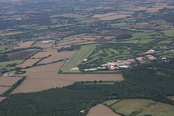
Earls Colne Airfield | |||||||||||||||
|---|---|---|---|---|---|---|---|---|---|---|---|---|---|---|---|
 The airfield in 2010 | |||||||||||||||
| Summary | |||||||||||||||
| Location | Earls Colne, Essex, England | ||||||||||||||
| Elevation AMSL | 222[1] ft / 68 m | ||||||||||||||
| Map | |||||||||||||||
| Runways | |||||||||||||||
| |||||||||||||||
| Helipads | |||||||||||||||
| |||||||||||||||
Earls Colne Airfield (ICAO: EGSR) is a general aviation aerodrome located south-east of the village of Earls Colne, Essex, England.
The site was previously RAF Earls Colne, a Royal Air Force station which was primarily used by the United States Army Air Forces.
History
[edit]
The following units were here at some point:[2]
- No. 38 Group Communication Flight RAF (October 1944 - May 1946)[3]
- No. 296 Squadron RAF between 29 September 1944 and 23 January 1946 using Armstrong Whitworth Albemarle I, V, & VI and the Handley Page Halifax V, III & A.7[4]
- No. 297 Squadron RAF between 30 September 1944 and 1 April 1946 using Albemarle I, II, V & VI and the Halifax V, III & A.7[4]
- 94th Bombardment Group
- 323d Bombardment Group
- 331st Bombardment Squadron
- 332nd Bombardment Squadron
- 333rd Bombardment Squadron
- 410th Bombardment Squadron
- 453rd Bombardment Squadron
- 454th Bombardment Squadron
- 455th Bombardment Squadron
- 456th Bombardment Squadron
Post-war
[edit]The following companies were here at some point:[2]
- Anglian Flight Centres
- Bulldog Aviation
- Essex Air Ambulance
- Essex Flying School
- Herts Air Ambulance
See also
[edit]References
[edit]Citations
[edit]- ^ Falconer 2012, p. 87.
- ^ a b "Earls Colne". Airfields of Britain Conservation Trust. Retrieved 25 September 2021.
- ^ Sturtivant, Hamlin & Halley 1997, p. 183.
- ^ a b Jefford 1988, p. 84.
External links
[edit]- British Pathé 1943 [1]
Bibliography
[edit]- Falconer, J. (2012). RAF Airfields of World War 2. UK: Ian Allan Publishing. ISBN 978-1-85780-349-5.
- Jefford, C.G. (1988). RAF Squadrons. A comprehensive record of the movement and equipment of all RAF squadrons and their antecedents since 1912. Shrewsbury: Airlife. ISBN 1-85310-053-6.
- Sturtivant, R.; Hamlin, J.; Halley, J. (1997). Royal Air Force flying training and support units. UK: Air-Britain (Historians). ISBN 0-85130-252-1.
