Al Huwaila
اَلْحُوَيْلَة | |
|---|---|
Abandoned town | |
 Al Huwaila Location in Qatar | |
| Coordinates: 25°56′00″N 51°27′00″E / 25.93333°N 51.45000°E[1] | |
| Country | |
| Municipality | Al Shamal |
| Zone | Zone 77 |
| District no. | 326 |
| Area | |
| • Total | 3.0 sq mi (7.7 km2) |
Al Huwaila (Arabic: اَلْحُوَيْلَة, romanized: Al Ḩuwaylah; also spelled Lehwaila) is an abandoned town in Qatar located in the municipality of Al Shamal.[3][4] Prior to the 18th century, and as perhaps as early as the 16th century, it served as Qatar's main town before its population migrated elsewhere.[5]
Nearby areas include Jebel Jassassiyeh to the immediate west and Ras Laffan to the east.[4]
Etymology[edit]
The town's name comes from the Arabic word "tahawala", which is translated as "to divert". This name was earned due to the area's low elevation which allowed it to divert the flow of water from a nearby valley.[4]
History[edit]
Ottoman records make the earliest known mention of Al Huwaila in 1555. The records state that, at that time, the Qatar Peninsula was ruled by Mohammed bin Sultan bani Muslim of the Al-Musallami tribe and that he had his seat of power in Al Huwaila.[5]
In the 1820s, George Barnes Brucks carried out the first British survey of the Persian Gulf.[6] He recorded the following notes about Al Huwaila, which he referred to as Al Owhale:
Al Owhale is a town in lat. 25° 56' 45" N., long. 51° 30' 30" E. It is defended by a small square Ghuree, and is the principal place on the coast. It is subject to Bahrein. It is inhabited by about four hundred and fifty of the Abookara [Al Kuwari] Tribe, formerly one of the most powerful in these parts, but now incorporated with the Uttoobees. It has a few boats belonging to it, contains water, and has some supplies of cattle. The people are mostly employed as fishermen, or in the coasting trade. This is one of the principal stations during the pearl fishery season.[7]
A survey conducted by the British Hydrographic Office in 1890 reflects on Al Huwaila's drastic decline during the mid-19th century, describing the town as such:
Al Howeila is a small town and fort 6 miles W.N.W. of Ras Laffan. The coast makes a small bay here, in which the reef extends 11⁄2 miles off shore. It has a square fort visible 8 miles. The people are employed in the pearl fishery. In 1887 the place was found to be deserted. The north point of the little bay is called 'Ras al Marlina, close to the southward of which the pearl boats find shelter during a shamal.[8]
John Gordon Lorimer mentions Al Huwaila in his 1908 manuscript of the Gazetteer of the Persian Gulf, stating:
In English at one time known as "Owhale". A deserted town on the east coast of Qatar about midway between Dhakhirah and the extremity of the peninsula. There are numerous wells in the vicinity, 2 miles inland from the sea, but the water is of indifferent quality. Before Zubarah and Dohah rose to importance, Huwailah was the chief town of Qatar. It is believed that the inhabitants were originally Al Musallam, who were expelled by the Shaikhs of Bahrein, and that thereafter they were Al Bin 'Ali up to about 1850.[9]
Gallery[edit]
-
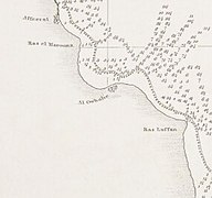 Al Huwaila (Al Owhale) in G.B. Bruck's 1824 map
 -
 A road sign for Al Huwaila
 -
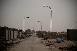 Road to Al Huwaila


References[edit]
- ^ "Al Huwailah: Qatar". geographic.org. Retrieved 18 January 2019.
- ^ "District Area Map". Ministry of Development Planning and Statistics. Retrieved 20 May 2019.
- ^ "Qatar Development Atlas - Part 1" (PDF). Ministry of Development Planning and Statistics. 2010. p. 10. Archived from the original (PDF) on 18 July 2020. Retrieved 18 January 2019.
- ^ a b c "District map". The Centre for Geographic Information Systems of Qatar. Archived from the original on 24 November 2020. Retrieved 18 January 2019.
- ^ a b Fromherz, Allen (13 April 2012). Qatar: A Modern History. Georgetown University Press. p. 4.
- ^ Mark Hobbs. "George Barnes Brucks and the First English Survey of the Gulf". Qatar Digital Library. Retrieved 19 January 2019.
- ^ G.B. Brucks; Robert Hughes Thomas (1856). "Historical and other information connected with place in the Persian Gulf". Bombay Education Society's Press. p. 560.
- ^ The Persian Gulf pilot: comprising the Persian Gulf, Gulf of Omán; and Makran coast. Great Britain: Hydrographic Dept. 1890. p. 126. This article incorporates text from this source, which is in the public domain.
- ^ J. G. Lorimer (1908). "'Gazetteer of Arabia Vol. I' [854] (909/1050)". Qatar Digital Library. Retrieved 19 January 2019. This article incorporates text from this source, which is in the public domain.
Capital: Madinat ash Shamal | |||||
| Zone 77 |
| ||||
| Zone 78 |
| ||||
| Zone 79 |
| ||||