Size of this preview: 800 × 496 pixels. Other resolutions: 320 × 198 pixels | 640 × 396 pixels | 1,001 × 620 pixels.
Original file (1,001 × 620 pixels, file size: 107 KB, MIME type: image/png)
Summary
Kopsavilkums
| Description |
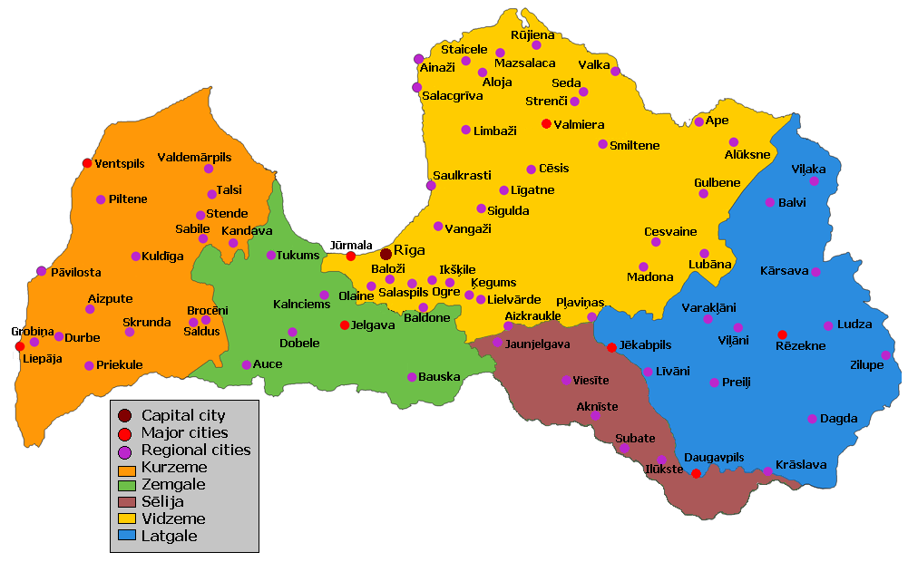
English: Map of historical regions in Latvia, cities and towns.
Latviešu: Latvijas kultūrvēsturisko novadu un pilsētu karte.
Lietuvių: Latvijos istoriniai etnografiniai regionai ir miestai. |
| Date | |
| Source | Own work |
| Author | Roalds |
Licensing
I, the copyright holder of this work, hereby publish it under the following licenses:

|
Permission is granted to copy, distribute and/or modify this document under the terms of the GNU Free Documentation License, Version 1.2 or any later version published by the Free Software Foundation; with no Invariant Sections, no Front-Cover Texts, and no Back-Cover Texts. A copy of the license is included in the section entitled GNU Free Documentation License. |
This file is licensed under the Creative Commons Attribution-Share Alike 3.0 Unported license.
- You are free:
- to share – to copy, distribute and transmit the work
- to remix – to adapt the work
- Under the following conditions:
- attribution – You must give appropriate credit, provide a link to the license, and indicate if changes were made. You may do so in any reasonable manner, but not in any way that suggests the licensor endorses you or your use.
- share alike – If you remix, transform, or build upon the material, you must distribute your contributions under the same or compatible license as the original.
You may select the license of your choice.
File history
Click on a date/time to view the file as it appeared at that time.
| Date/Time | Thumbnail | Dimensions | User | Comment | |
|---|---|---|---|---|---|
| current | 06:32, 8 August 2021 | | 1,001 × 620 (107 KB) | Pirags | Reverted to version as of 07:02, 2 October 2018 (UTC) aizmirsta Sēlija |
| 15:02, 22 July 2021 |  | 1,000 × 590 (190 KB) | Lasks | -Kalnciems +Iecava, Koknese | |
| 07:02, 2 October 2018 |  | 1,001 × 620 (107 KB) | Olgerts V | Limbaži | |
| 14:25, 7 May 2009 |  | 1,001 × 620 (99 KB) | Roalds~commonswiki | {{Information |Description={{en|1=Map of historical regions in Latvia, cities and towns}} {{lv|1=Latvijas kultūrvēsturisko novadu un pilsētu karte}} {{lt|1=Latvijos istoriniai etnografiniai regionai ir miestai.}} |Source=Own work |Author=Roalds |Date=2 |
File usage
The following pages on the English Wikipedia use this file (pages on other projects are not listed):
Global file usage
The following other wikis use this file:
- Usage on an.wikipedia.org
- Usage on az.wikipedia.org
- Usage on bat-smg.wikipedia.org
- Usage on ba.wikipedia.org
- Usage on be-tarask.wikipedia.org
- Usage on be.wikipedia.org
- Usage on bg.wikipedia.org
- Usage on bn.wikipedia.org
- Usage on ca.wikipedia.org
- Usage on csb.wikipedia.org
- Usage on cs.wikipedia.org
- Usage on da.wikipedia.org
- Usage on el.wikipedia.org
- Usage on eo.wikipedia.org
- Usage on es.wikipedia.org
- Usage on et.wikipedia.org
- Usage on fa.wikipedia.org
- Usage on fr.wikipedia.org
- Usage on hu.wikipedia.org
View more global usage of this file.