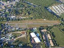
Marlboro Airport (Closed) | |||||||||||
|---|---|---|---|---|---|---|---|---|---|---|---|
 Marlboro Airport when it was open, with a helicopter that just took off | |||||||||||
| Summary | |||||||||||
| Airport type | Public | ||||||||||
| Operator | Sandra A. Stetson | ||||||||||
| Serves | Marlborough, Massachusetts | ||||||||||
| Location | Marlborough, Massachusetts | ||||||||||
| Elevation AMSL | 285 ft / 87 m | ||||||||||
| Coordinates | 42°20′35.4″N 71°30′32.4″W / 42.343167°N 71.509000°W | ||||||||||
| Map | |||||||||||
| Runways | |||||||||||
| |||||||||||
Marlboro Airport, (IATA: MXG, FAA LID: 9B1) in Marlborough, Massachusetts, was a public airport that was in operation from 1922 to 2019.
History[edit]
Marlboro Airport was founded in 1922, the era when barnstormers flew "by the seat of their pants." It was the oldest continuously operating commercial field in the Commonwealth of Massachusetts until its closure. There was one fixed-base operator, Don's Flying Service, named for former airport manager Don LaCouture Sr. and offered fixed-wing and helicopter flight instruction, tie-downs and hangar space, and major and minor aircraft repairs.[citation needed]
Chapter 673 of the Experimental Aircraft Association was based at Marlboro Airport.[citation needed]
In April 2010, the airport owner sued the government[2] claiming that the airport's runway was damaged by heavy vehicles accompanying President Obama's secret service fleet. The government settled with the airport owner's widow a year after his death.,[3] however the funds were never used to repave the airport which was closed shortly thereafter.[4]
Its final owner was Sandra A. Stetson, widow of prior owner G. Robert Stetson, Jr. Robert died on April 27, 2012, at the age of 66.[5] It had one runway, and at the end of its life averaged 37 flights per day with approximately 40 aircraft based on its field.[6] In December 2018, Sandra Stetson sold the airport to Capital Group Properties,[7] which plans to redevelop the site into the Airport Industrial Park.[8]
References[edit]
- ^ "Airline and Airport Code Search". IATA. Retrieved 30 March 2016.
- ^ Howard, Zach (29 September 2011). "Tiny airport blames Obama motorcade for ruined runway". Reuters.
- ^ "Marlboro Airport owner settles complaint about runway damage during Obama visit".
- ^ "A final descent for one of the state's oldest airports - the Boston Globe".
- ^ Tota, Matt (April 27, 2012). "Marlboro Airport owner Robert Stetson dead at 66". The MetroWest Daily News.
- ^ "Developer plans to transform Marlboro Airport into an industrial park". MetroWest Daily News. January 3, 2019.
- ^ "Capital Group Properties – Airport Industrial Park".
External links[edit]
- Resources for this airport:
- FAA airport information for 9B1
- AirNav airport information for 9B1
- FlightAware airport information and live flight tracker
- SkyVector aeronautical chart for 9B1
