This list of canyons and gorges includes both land and submarine canyons with the land canyons being sorted by continent and then by country.
Africa[edit]
-
 Blyde River Canyon, South Africa
 -
 Fish River Canyon, Namibia
 -
 Olduvai Gorge, Tanzania


South Africa[edit]
- Blyde River Canyon, Mpumalanga
- Kloof, KwaZulu-Natal (The word Kloof means 'gorge' in Afrikaans[citation needed])
- Komati Gorge
- Lanner Gorge
- Oribi Gorge, KwaZulu-Natal
Other countries[edit]
- Lesotho - Senqu River Canyon
- Lesotho - Maletsunyane River Gorge
- Lesotho - Makhaleng River Canyon
- Cameroon- Gorges de Kola
- Egypt- Arada Canyon
- Ethiopia- Blue Nile Gorge
- Madagascar- Isalo Canyon
- Mali—Talari Gorges
- Morocco- Todgha Gorge
- Namibia—Fish River Canyon
- Republic of Congo- Gorges of Diosso
- Tanzania—Olduvai Gorge
- Tunisia—Mides Canyon
Americas[edit]
-
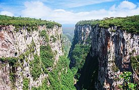 Itaimbezinho Canyon, Brazil
 -
 Ouimet Canyon, Canada
 -
 Sumidero Canyon, Mexico
 -
 Grand Canyon, USA


Argentina[edit]
Brazil[edit]
- Guartelá Canyon, Paraná
- Itaimbezinho, Aparados da Serra National Park, Rio Grande do Sul
- Fortaleza Canyon, Aparados da Serra National Park, Rio Grande do Sul
Canada[edit]
- Agawa Canyon, Ontario
- Barron River (Ontario)
- Beggerlay Canyon, British Columbia
- Big Canyon, British Columbia
- Big Creek Canyon, British Columbia
- Bull Canyon, British Columbia
- Canyon Sainte-Anne, Quebec
- Coaticook Gorge, Quebec
- Cottonwood Canyon, British Columbia
- Coquihalla Canyon, British Columbia
- Deserters Canyon, British Columbia
- Driftwood Canyon, British Columbia
- Eakin Creek Canyon, British Columbia
- Eaton Canyon, Quebec
- Fort George Canyon, British Columbia
- French Bar Canyon, British Columbia
- Giscome Canyon, British Columbia
- Great Canyon (Homathko River), British Columbia
- The Green Bowl, British Columbia
- Hagwilget Canyon, British Columbia
- Helmcken Canyon, British Columbia
- Kitselas Canyon, British Columbia
- Klinaklini Canyon, British Columbia
- Klootch Canyon, British Columbia
- Klootchman Canyon, British Columbia
- Lava Canyon, British Columbia
- Marble Canyon, British Columbia
- Nanaimo River Canyon, British Columbia
- Waddington Canyon, British Columbia
- Maligne Canyon, Alberta
- Marie Canyon, British Columbia
- Mistaya Canyon, Alberta
- Painted Chasm, British Columbia
- Farwell Canyon, British Columbia
- Fraser Canyon, British Columbia
- Grand Canyon of the Stikine, British Columbia
- Horseshoe Canyon, Alberta
- Horsethief Canyon, Alberta
- Niagara Gorge, Ontario
- Ouimet Canyon, Ontario
Chile[edit]
Colombia[edit]
- Chicamocha Canyon, Santander
- Saturban canyon, Santander
Mexico[edit]
Peru[edit]
- Colca Canyon, Arequipa
- Cotahuasi Canyon, Arequipa
United States[edit]


- Antelope Canyon, Arizona
- Ausable Chasm, New York
- Bad Rock Canyon, Montana
- Bad Branch Gorge, Kentucky
- Blackhand Gorge, Ohio
- Bighorn Canyon, Montana and Wyoming
- Big South Fork of the Cumberland River gorge, Kentucky and Tennessee
- Big Thompson River Canyon, Colorado
- Black Canyon of the Gunnison, Colorado
- Blackwater Canyon, West Virginia
- Bluejohn Canyon, Utah—site of Aron Ralston's accident
- Breaks Canyon, Kentucky and Virginia
- Buckskin Gulch, Utah—possibly the longest, deepest slot canyon in the world at over 13 mi (21 km); a tributary of the Paria River
- Cane Creek Canyon, Alabama
- Canyon de Chelly, Arizona
- Canyonlands National Park, canyons of the Colorado River and its main tributary the Green River, Utah
- Canyons of the Escalante, Grand Staircase–Escalante National Monument, Utah
- Cataract Canyon, Utah
- Chaco Canyon, New Mexico
- Cheat Canyon, West Virginia
- Chitistone Canyon, Alaska
- Cloudland Canyon, Georgia
- Columbia River Gorge, Washington and Oregon
- Desolation Canyon, Utah
- Dismals Canyon, Alabama
- Echo Canyon, Nevada
- Fall Brook Gorge, New York
- Flaming Gorge, Utah and Wyoming
- Flume Gorge, New Hampshire
- Franklin Gorge, West Virginia
- Fremont River Canyon, Utah
- Gates of Lodore, Colorado
- Genesee River Gorge, New York
- Glen Canyon, Utah and Arizona
- Glenwood Canyon, Colorado
- Grand Canyon, Grand Canyon National Park, Arizona
- Grand Canyon of the Tuolumne, Yosemite National Park, California
- Grand Canyon of the Yellowstone, Yellowstone National Park, Wyoming
- Grand Coulee, Washington
- Gulf Hagas, Maine
- Hells Canyon, Idaho, Oregon and Washington
- Horseshoe Canyon, Utah
- James River Gorge, Virginia
- Kaaterskill Clove, New York
- Kanuti Canyon, Alaska
- Kern Canyon, California
- Kings Canyon, California
- Kolob Canyons, Zion National Park, Utah
- Keystone Canyon, Alaska
- Lehigh River Gorge, Pennsylvania
- Linville Gorge, North Carolina
- Little River Canyon, Alabama
- Logan Canyon, Utah
- Marble Canyon, Arizona
- Mather Gorge, Maryland and Virginia
- Mississippi Gorge, Minnesota
- Mianus River Gorge, New York
- Moses Coulee, Washington
- McKittrick Canyon, Guadalupe Mountains National Park, Texas
- New River Gorge, West Virginia
- Neversink Gorge, New York
- Niagara Gorge, New York
- Nine Mile Canyon, Utah
- Noatak Canyon, Alaska
- Palo Duro Canyon, Texas
- Paria River Canyon, southern Utah into northern Arizona
- Pine Creek Gorge, Pennsylvania
- Providence Canyon, Georgia
- Provo Canyon, Utah
- Quartermaster Canyon, Grand Canyon National Park, Arizona[2]
- Quechee Gorge, Vermont
- Red River Gorge, Kentucky
- Rio Grande Gorge, New Mexico
- Ripogenus Gorge, Maine
- Royal Gorge, Colorado
- Ruby Canyon, Colorado and Utah
- Sabino Canyon, Arizona
- Saint Christopher's Canyon, Aibonito and Barranquitas, Puerto Rico
- Salt River Canyon, Arizona
- San Rafael River Gorge, Utah
- Santa Elena Canyon, Big Bend National Park, Texas (also in Big Bend N.P.: Boquillas and Mariscal Canyons)
- Smoke Hole Canyon, West Virginia
- Tallulah Gorge, Georgia
- Tennessee River Gorge, Tennessee into Alabama
- The Trough, West Virginia
- Turnback Canyon, Alaska
- Titus Canyon, Death Valley, California (also in Death Valley: Golden, Mosaic and Natural Bridge Canyons)
- Virgin River Gorge, Arizona and Utah
- Waimea Canyon, Hawaii
- Walnut Canyon, Arizona
- Westwater Canyon, Utah
- Wind River Canyon, Wyoming
- Winner Creek Gorge, Alaska
- Wintergreen Gorge, Pennsylvania
- Yakima River Canyon, Washington
- Zion Canyon, Utah
Other countries[edit]
- Bolivia—Grand Canyon of Torotoro, Torotoro, Potosi Department
- Nicaragua—Somoto Canyon, Somoto, Madriz
Asia[edit]
-
 One of the Three Gorges of the Yangtze river, China
 -
 Siq, Jordan
 -
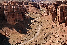 Sharyn Canyon, Kazakhstan
 -
 Kali Gandaki Gorge, Nepal
 -
 Indus River Gorge, Pakistan


China[edit]
- Huguan Taihang Grand Canyon, Shanxi
- Longtan Grand Canyon, Hebei
- Norton Couloir, Tibet
- Qutang Gorge, Hubei
- Red Stone Gorge, Henan
- Taihangshan Gorge, Shanxi
- Three Gorges, Chongqing
- Three Parallel Rivers, Yunnan
- Tiger Leaping Gorge, Yunnan
- Wu Gorge, Hubei
- Xiling Gorge, Hubei
- Yarlung Tsangpo Grand Canyon, Tibet Autonomous Region
- Yarlung Zangbo Grand Canyon, Tibet Autonomous Region
Nepal[edit]
India[edit]
- Gandikota, Kadapa District, Andhra Pradesh
- Garadia Mahadev, Kota district, Rajasthan
- Idukki, Western Ghats, Kerala
- Raneh Falls, Chatarpur district, Madhya Pradesh
- Satkosia Tiger Reserve, Angul district, Odisha
- Dayangmukh, Dima Hasao, Assam
- Assi Ganga, Uttarkashi, Uttarakhand
- Shatadru, Kufri, Himachal Pradesh
Philippines[edit]
Other countries[edit]
- Indonesia—Cukang Taneuh, Pangandaran, Brown Canyon in Semarang
- Jordan—Siq, Petra
- Kazakhstan—Sharyn Canyon
- Kyrgyz Republic—Ala Archa gorge of Ala Archa National Park
- Oman—Wadi Ghul
- Pakistan—Indus River Gorge through the Himalaya; Soan River gorge
- Taiwan—Taroko Gorge of Taroko National Park
Europe[edit]
-
 Cheddar Gorge, England
 -
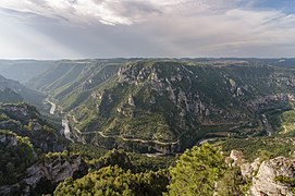 Gorges du Tarn, France
 -
 Fjaðrárgljúfur Canyon, Iceland
 -
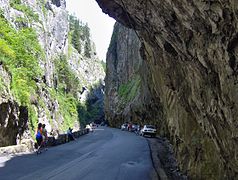 Bicaz Gorge, Romania
 -
 Aare Gorge, Switzerland


Albania[edit]
Austria[edit]
France[edit]
- Ardèche Gorges, Auvergne-Rhône-Alpes
- Daluis Gorge, Provence-Alpes-Côte d'Azur
- Gorges du Tarn, Occitanie
- Verdon Gorge, Provence-Alpes-Côte d'Azur
Georgia[edit]
Greece[edit]
- Agia Eirini Gorge, Crete
- Ha Gorge, Crete
- Imbros Gorge, Crete
- Kotsifos Gorge, Crete
- Kourtaliotiko Gorge, Crete
- Richtis Gorge, Crete
- Sarakina Gorge, Crete
- Samaria Gorge, Crete
- Vikos Gorge, Vikos–Aoös National Park
Italy[edit]
Montenegro[edit]
Norway[edit]
- Allmannajuvet Canyon, Rogaland
- Jutulhogget Canyon, Hedmark
- Jutulhogget Canyon, Oppland
- Mågålaupet Gorge, Sør-Trøndelag
- Sautso Canyon, Finnmark
Russia[edit]

Switzerland[edit]
Turkey[edit]
- Boğazpınar Canyon, Mersin Province
- Harmanköy Canyon, Bilecik
- Ulubey Canyon, Uşak
- Valla Canyon, Küre, Kastamonu
United Kingdom[edit]
England[edit]
- Avon Gorge, Bristol
- Cauldron Snout, County Durham[3]
- Cheddar Gorge, Somerset
- Cliviger Gorge, Lancashire
- Cresswell Crags, Nottinghamshire
- Ebbor Gorge, Somerset
- Gordale Scar, Yorkshire[4]
- Harehope Canyon, Northumberland
- How Stean Gorge, Yorkshire
- Ironbridge Gorge, Shropshire
- Lud's Church, Staffordshire
- Sleightholme Beck Gorge, Yorkshire[5]
- Staward Gorge, Northumberland
- Winnats Pass, Derbyshire
Scotland[edit]
- Ailnack Gorge, Banffshire[6]
- Alva Glen, Clackmannanshire
- Black Rock Gorge, Ross-shire
- Burn o' Vat, Aberdeenshire
- Corrieshalloch Gorge, Ross-shire[6]
- Craighall Gorge, Perthshire
- Crichope Linn, Dumfriesshire
- Dean Gorge in Edinburgh, Midlothian
- Dob's Linn, Dumfriesshire[7]
- Glen Valtos on Isle of Lewis, Ross-shire[6]
- Ness Glen, Ayrshire[8]
- Nethan Gorge, Lanarkshire
Wales[edit]
- Aberglaslyn Pass, Caernarfonshire
- Clydach Gorge, Monmouthshire
- Fairy Glen (Ffos Anoddun), at Betws-y-coed, Caernarfonshire
Other countries[edit]
- Bulgaria—Trigrad Gorge
- Greenland—Greenland's Grand Canyon
- Iceland—Fjaðrárgljúfur Canyon
- Macedonia—Matka Canyon
- Romania—Bicaz Gorge
- Serbia—Rugova Canyon
- Ukraine—Dniester Canyon
- Spain—Congost de Mont-Rebei
Oceania[edit]
-
 Skippers Canyon, New Zealand
 -
 Cathedral Gorge, Purnululu National Park, Western Australia
 -
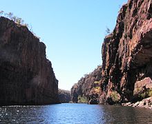 Katherine Gorge, Northern Territory of Australia
 -
 Murchison River Gorge, Western Australia
 -
 Capertee Valley, New South Wales
 -
 Jamison Valley, New South Wales


Australia[edit]


- Barfold Gorge, Victoria
- Barron Gorge, Queensland
- Bouldercombe Gorge, Queensland
- Cambanoora Gorge, Queensland
- Capertee Valley, New South Wales
- Carnarvon Gorge, Queensland
- Cataract Gorge, Tasmania
- Dimond Gorge, Western Australia
- Galston Gorge, New South Wales
- Geikie Gorge National Park, Western Australia
- Jamison Valley, New South Wales
- Karijini National Park, Western Australia—contains gorges named Dales, Hamersley, Hancock, Joffre, Kalamina, Knox, Munjina, Range, Red, Weano, Wittenoom and Yampire;[9] blue asbestos exists in the latter two gorges[10]
- Katherine Gorge, Northern Territory
- Kings Canyon, Northern Territory
- Lerderderg Gorge, Victoria
- Little River Gorge, Victoria
- Loch Ard Gorge, Victoria
- Mossman Gorge, Queensland
- Murchison River Gorge, Western Australia
- Nepean Gorge, New South Wales
- North and South Gorges of North Stradbroke Island, Queensland
- Palm Valley, Northern Territory
- Porcupine Gorge, Queensland
- Purnululu National Park, Western Australia—Cathedral and Piccaninny Gorges,[11] and Echidna Chasm[12]
- Ravine des Casoars, South Australia
- Sturt Gorge, South Australia
- West MacDonnell National Park, Northern Territory
- Windjana Gorge, Western Australia
New Zealand[edit]

- Ashley Gorge, Canterbury region
- Buller Gorge, Buller
- Cromwell Gorge, Central Otago
- Karangahake Gorge, Coromandel Peninsula
- Karapoti Gorge, Wellington Region
- Kawarau Gorge, Central Otago
- Manawatū Gorge, Manawatū
- Ngauranga Gorge, Wellington City
- Poolburn Gorge, Central Otago
- Rakaia Gorge, Canterbury Region
- Skippers Canyon, Central Otago
- Taieri Gorge, South Otago
- Trotters Gorge, North Otago
- Waimakariri Gorge, Canterbury Region
- Weka Pass, Canterbury Region
- Windy Canyon, Great Barrier Island
Submarine canyons[edit]
A submarine canyon is a steep-sided valley with nearly vertical walls cut into the seabed of the continental margin, sometimes extending well onto the continental shelf.[13]
Atlantic Ocean[edit]

- Amazon Canyon, extending from the Amazon River off the coast of Brazil
- Avilés Canyon, off the coast of Asturias, Spain
- Baltimore Canyon, off the coast of Maryland
- Congo Canyon, extending from the Congo River off the coast of the Democratic Republic of the Congo
- Great Bahama Canyon, between the islands of The Bahamas
- Hatteras Canyon, off the coast of North Carolina
- Hudson Canyon, extending from the Hudson River off the coast of New York City between the Long Island and the New Jersey coasts of the United States
- Mona Canyon, off the coast of western Puerto Rico
- Nazaré Canyon, off the coast of Portugal
- Whittard Canyon, off the southwest coast of Ireland
- Wilmington Canyon, off the coast of Delaware, the United States[14]
Indian Ocean[edit]
- Ganges Canyon, extending from the Ganges off the coast of India
- Indus Canyon, extending from the Indus River off the coast of Pakistan
- Perth Canyon, extending from the Swan River off the coast of Fremantle. Western Australia
Pacific Ocean[edit]

- Bering Canyon, in the Bering Sea near the Aleutian Islands, Alaska, the United States
- Kaikoura Canyon, off the coast of the Kaikoura Peninsula, New Zealand
- La Jolla Canyon, off the coast of La Jolla, California
- Monterey Canyon, off the coast of central California, the United States
- Pribilof Canyon, in the Bering Sea, southeast of the Pribilof Islands, Alaska
- Scripps Canyon, off the coast of La Jolla, southern California
- Zhemchug Canyon, in the central Bering Sea between the Aleutian Islands of Alaska and the Kamchatka Peninsula of Russia; the largest submarine canyon in the world based on drainage area
Black Sea[edit]
- Danube Canyon, off the coast of Romania
References[edit]
- ^ Ruban, Dmitry A.; Zerfass, Henrique; Pugatchev, Vladimir I. (2009-08-01). "Triassic synthems of southern South America (southwestern Gondwana) and the Western Caucasus (the northern Neotethys), and global tracing of their boundaries". Journal of South American Earth Sciences. 28 (2): 155–167. doi:10.1016/j.jsames.2009.03.003. hdl:2263/11274. ISSN 0895-9811.
- ^ U.S. Geological Survey Geographic Names Information System: Quartermaster Canyon
- ^ Mitton, Geraldine Edith (1924). A. & C. Black, Limited. Durham. p. 198. Retrieved 22 March 2024.
{{cite book}}: CS1 maint: location missing publisher (link) - ^ Dean, Dennis R (2007). Geology and Its Cultural Influence in Britain, 1765-1835. Scholars' Facsimiles & Reprints. p. 134. ISBN 9780820115559. Retrieved 7 August 2022.
- ^ Holliday, D W; Burgess, I C (1979). Geology of the Country Around Brough-under-Stainmore. H.M. Stationery Office. p. 45. ISBN 0118840053.
- ^ a b c Gillen, Con (31 August 2013). Geology and Landscapes of Scotland. Dunedin Academic Press Ltd. ISBN 9781903544884.
- ^ Aldridge, Richard John (2000). British Silurian Stratigraphy. Joint Nature Conservation Committee. ISBN 9781861074782. Retrieved 23 March 2024.
- ^ Eyles, Victor Ambrose (1949). Geology of Central Ayrshire: Explanation of One-inch Sheet 14. H.M. Stationery Office.
- ^ "Karijini National Park Visitor guide" (PDF). Explore Parks WA (note: PDF file link appears in "Downloads & Resources" tab of webpage: parks.dpaw.wa.gov.au/park/karijini). Department of Parks and Wildlife. 2016. Archived (PDF) from the original on 2016-11-04. Retrieved 2016-11-04.
- ^ "Australia's North West › Pilbara › Karijini National Park › Welcome (tab)". Explore Parks WA. Department of Parks and Wildlife. 2013. Archived from the original on 2016-11-04. Retrieved 2016-11-04.
- ^ "Australia's North West › Kimberley › Purnululu › Piccaninny Creek". Explore Parks WA. Department of Parks and Wildlife. 2013. Archived from the original on 2016-03-10. Retrieved 2016-11-04.
- ^ "Australia's North West › Kimberley › Purnululu › Echidna Chasm". Explore Parks WA. Department of Parks and Wildlife. 2013. Archived from the original on 2016-03-23. Retrieved 2016-11-04.
- ^ Shepard, F.P., 1963. Submarine Geology. Harper & Row, New York
- ^ Arthur Newell Strahler, Physical Geography. New York: John Wiley & Sons, Inc., 1960, Second Edition, p. 290