
Size of this JPG preview of this TIF file: 800 × 479 pixels. Other resolutions: 320 × 192 pixels | 640 × 384 pixels | 1,024 × 614 pixels | 1,280 × 767 pixels | 2,560 × 1,534 pixels | 6,037 × 3,618 pixels.
Original file (6,037 × 3,618 pixels, file size: 62.49 MB, MIME type: image/tiff)
Summary
| Description |
English: Aerial view of village. View printed in black; border and clouds in light tan. Includes index to points of interest. Available also through the Library of Congress Web site as a raster image. PM3 Acquisitions control no.: 2003-22 |
||
| Title | Marlborough, N.Y. | ||
| Shelf ID | G3804.M375A3 1891 .B8 | ||
| Date | |||
| Source | https://www.loc.gov/item/2003630236/ | ||
| Author | Burleigh Litho; Burleigh, L. R. (Lucien R.) | ||
| Permission (Reusing this file) |
|
||
| Other versions |
|
||
| Location | Marlboro · United States · New York (State) · New York | ||
| Part of | American Memory · Cities And Towns · Catalog · Panoramic Maps · Geography And Map Division | ||
| Subject | United States · Marlboro · New York (State) · Aerial Views · Marlboro (N.Y.) |


Licensing
|
This is a faithful photographic reproduction of a two-dimensional, public domain work of art. The work of art itself is in the public domain for the following reason:
The official position taken by the Wikimedia Foundation is that "faithful reproductions of two-dimensional public domain works of art are public domain".
This photographic reproduction is therefore also considered to be in the public domain in the United States. In other jurisdictions, re-use of this content may be restricted; see Reuse of PD-Art photographs for details. | ||||
File history
Click on a date/time to view the file as it appeared at that time.
| Date/Time | Thumbnail | Dimensions | User | Comment | |
|---|---|---|---|---|---|
| current | 06:16, 7 June 2018 | 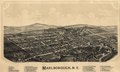 | 6,037 × 3,618 (62.49 MB) | Fæ | LOC Maps https://www.loc.gov/item/2003630236/ #7336 |
File usage
The following pages on the English Wikipedia use this file (pages on other projects are not listed):