
Size of this PNG preview of this SVG file: 800 × 400 pixels. Other resolutions: 320 × 160 pixels | 640 × 320 pixels | 1,024 × 512 pixels | 1,280 × 640 pixels | 2,560 × 1,280 pixels | 1,000 × 500 pixels.
Original file (SVG file, nominally 1,000 × 500 pixels, file size: 987 KB)
Summary
| Description |
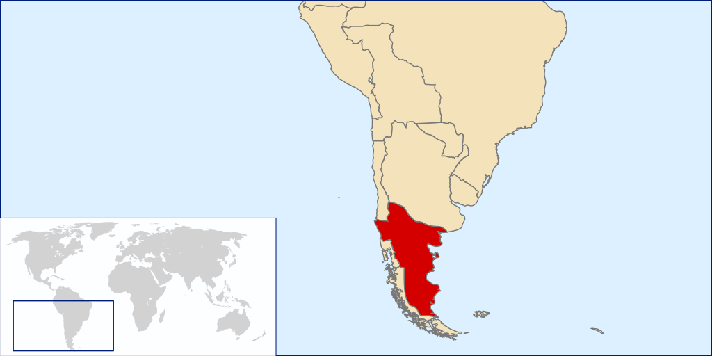
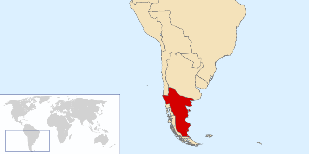
Español: Mapa localizador del Reino de la Araucanía y la Patagonia (1860-1862 aprox.).
Este mapa solo representa una idea básica de la localización del territorio reclamado por este estado no reconocido, puesto que no existe certeza exacta de las zonas reclamadas por el supuesto reino. Los mapas de otros países tampoco son representaciones fidedignas de sus fronteras en la época. La zona patagónica de Aisén, Magallanes y Tierra del Fuego aparece como un territorio distinto a Chile y Argentina al ser una zona reclamada por ambos países durante la época. La zona de la Patagonia Oriental, también reclamada por ambos, era cubierta por las reclamaciones del Reino de la Araucanía y la PatagoniaEnglish: Locator map of the Kingdom of Araucania and Patagonia (approx. 1860-1862).
The map shows only an idea of the territory disputed by the unrecognized Kingdom because there isn't any exact definition of it. Also the historical frontiers of other countries aren't accurate. The zone of Aysen, Magallanes and Tierra del Fuego islands are shown as a separate entity because it was disputed by Chile and Argentina at the time. Most of Western Patagonia (also disputed by both countries) are shown as a territory of the Kingdom. |
| Date | |
| Source | self-made based in Image:LocationChile.svg and Image:Continents.svg |
| Author | B1mbo |
Licensing
I, the copyright holder of this work, hereby publish it under the following licenses:

|
Permission is granted to copy, distribute and/or modify this document under the terms of the GNU Free Documentation License, Version 1.2 or any later version published by the Free Software Foundation; with no Invariant Sections, no Front-Cover Texts, and no Back-Cover Texts. A copy of the license is included in the section entitled GNU Free Documentation License. |
This file is licensed under the Creative Commons Attribution-Share Alike 4.0 International, 3.0 Unported, 2.5 Generic, 2.0 Generic and 1.0 Generic license.
- You are free:
- to share – to copy, distribute and transmit the work
- to remix – to adapt the work
- Under the following conditions:
- attribution – You must give appropriate credit, provide a link to the license, and indicate if changes were made. You may do so in any reasonable manner, but not in any way that suggests the licensor endorses you or your use.
- share alike – If you remix, transform, or build upon the material, you must distribute your contributions under the same or compatible license as the original.
You may select the license of your choice.
File history
Click on a date/time to view the file as it appeared at that time.
| Date/Time | Thumbnail | Dimensions | User | Comment | |
|---|---|---|---|---|---|
| current | 02:50, 29 March 2008 | | 1,000 × 500 (987 KB) | B1mbo | {{Information |Description={{es|Mapa localizador del Reino de la Araucanía y la Patagonia (1860-1862 aprox.). Este mapa solo representa una idea básica de la localización del territorio reclamado por este |
File usage
The following pages on the English Wikipedia use this file (pages on other projects are not listed):
Global file usage
The following other wikis use this file:
- Usage on ar.wikipedia.org
- Usage on br.wikipedia.org
- Usage on ca.wikipedia.org
- Usage on es.wikipedia.org
- Usage on fi.wikipedia.org
- Usage on fr.wikipedia.org
- Usage on ga.wikipedia.org
- Usage on gl.wikipedia.org
- Usage on he.wikipedia.org
- Usage on id.wikipedia.org
- Usage on it.wikipedia.org
- Usage on ja.wikipedia.org
- Usage on ko.wikipedia.org
- Usage on nl.wikipedia.org
- Usage on pt.wikipedia.org
- Usage on sv.wikipedia.org
- Usage on th.wikipedia.org
- Usage on www.wikidata.org
- Usage on zh.wikipedia.org