No higher resolution available.
Bromyard_railway_station_1921287_0d209dac.jpg (640 × 399 pixels, file size: 136 KB, MIME type: image/jpeg)
Summary
| Description |
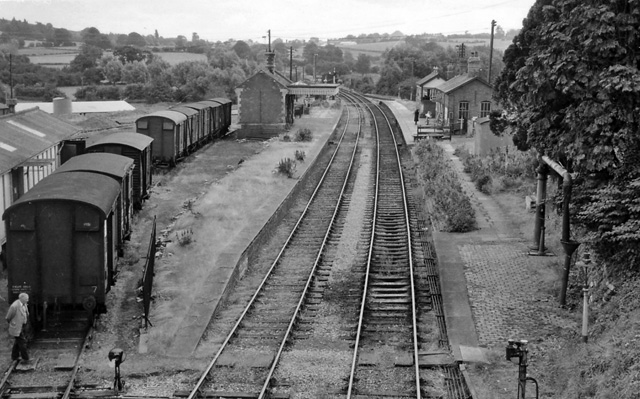
English: Bromyard Station (remains). View SE, towards Worcester; ex- Great Western Worcester - Bromyard - Leominster branch. Line closed completely on to Leominster 15/9/52 although kept intact for wagon storage until 1958; Bromyard station and line to Worcester (Leominster Junction) were closed completely on 7/9/64. Clearly in 1963 only the former Up platform line was in use. Nowadays, on the first mile out of Bromyard in the direction shown here, the miniature (2 ft.-gauge) Bromyard & Linton Railway runs. |
| Date | |
| Source | From geograph.org.uk |
| Author | Ben Brooksbank |
| Permission (Reusing this file) |
Creative Commons Attribution Share-alike license 2.0 |
| Camera location | | View this and other nearby images on: OpenStreetMap |
|---|
Licensing

|
This image was taken from the Geograph project collection. See this photograph's page on the Geograph website for the photographer's contact details. The copyright on this image is owned by Ben Brooksbank and is licensed for reuse under the Creative Commons Attribution-ShareAlike 2.0 license.
|
This file is licensed under the Creative Commons Attribution-Share Alike 2.0 Generic license.
Attribution: Ben Brooksbank
- You are free:
- to share – to copy, distribute and transmit the work
- to remix – to adapt the work
- Under the following conditions:
- attribution – You must give appropriate credit, provide a link to the license, and indicate if changes were made. You may do so in any reasonable manner, but not in any way that suggests the licensor endorses you or your use.
- share alike – If you remix, transform, or build upon the material, you must distribute your contributions under the same or compatible license as the original.
File history
Click on a date/time to view the file as it appeared at that time.
| Date/Time | Thumbnail | Dimensions | User | Comment | |
|---|---|---|---|---|---|
| current | 14:21, 15 November 2010 | | 640 × 399 (136 KB) | Chevin | == {{int:filedesc}} == {{Information |Description={{en|1=Bromyard Station (remains) View SE, towards Worcester; ex- Great Western Worcester - Bromyard - Leominster branch. Line closed completely on to Leominster 15/9/52 although kept intact for wagon stor |
File usage
The following pages on the English Wikipedia use this file (pages on other projects are not listed):
Global file usage
The following other wikis use this file:
- Usage on www.wikidata.org