
Size of this preview: 800 × 501 pixels. Other resolutions: 320 × 200 pixels | 640 × 401 pixels | 1,024 × 642 pixels | 1,280 × 802 pixels | 2,000 × 1,253 pixels.
Original file (2,000 × 1,253 pixels, file size: 249 KB, MIME type: image/png)
Summary
| Description |
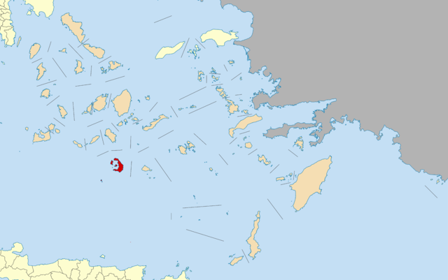
English: Locator map for Thira municipality (Santorin) in Greek region South Aegean (2011)
Deutsch: Lage der Gemeinde Thira (Santorin) in der griechischen Region Südliche Ägäis (2011) |
| Date | |
| Source | Own work |
| Author | Pitichinaccio |
Licensing
I, the copyright holder of this work, hereby publish it under the following licenses:

|
Permission is granted to copy, distribute and/or modify this document under the terms of the GNU Free Documentation License, Version 1.2 or any later version published by the Free Software Foundation; with no Invariant Sections, no Front-Cover Texts, and no Back-Cover Texts. A copy of the license is included in the section entitled GNU Free Documentation License. |
This file is licensed under the Creative Commons Attribution 3.0 Unported license.
- You are free:
- to share – to copy, distribute and transmit the work
- to remix – to adapt the work
- Under the following conditions:
- attribution – You must give appropriate credit, provide a link to the license, and indicate if changes were made. You may do so in any reasonable manner, but not in any way that suggests the licensor endorses you or your use.
You may select the license of your choice.
File history
Click on a date/time to view the file as it appeared at that time.
| Date/Time | Thumbnail | Dimensions | User | Comment | |
|---|---|---|---|---|---|
| current | 14:05, 7 November 2010 | | 2,000 × 1,253 (249 KB) | Pitichinaccio | == Summary == {{Information |Description={{en|1=Locator map for Thira municipality (Santorin) in Greek region South Aegean (2011)}} {{de|1=Lage der Gemeinde Thira (Santorin) in der griechischen Region Südliche Ägäis (2011)}} |Source={{own}} |Author=[[U |
File usage
The following pages on the English Wikipedia use this file (pages on other projects are not listed):
Global file usage
The following other wikis use this file:
- Usage on ar.wikipedia.org
- Usage on ca.wikipedia.org
- Usage on de.wikipedia.org
- Usage on el.wikipedia.org
- Usage on es.wikipedia.org
- Usage on fa.wikipedia.org
- Usage on fi.wikipedia.org
- Usage on fr.wikipedia.org
- Néa Kaméni
- Fira
- Thirassía
- Akrotiri (Santorin)
- Oia (Santorin)
- Santorin
- Asprónissi
- Paléa Kaméni
- Liste des dèmes de Grèce
- Imerovígli
- Pýrgos Kallístis
- Askaniá
- Îles Christianá
- Thíra (dème)
- Períssa
- Escháti
- Raid sur Santorin
- Modèle:Palette Dème de Thíra
- Mesariá (Santorin)
- Panagía Kaloú
- Vóthonas (Santorin)
- Vourvoúlos (Santorin)
- Monólithos (Santorin)
- Megalochóri (Santorin)
- Karterádos (Santorin)
- Agía Iríni (Thirasía)
- Ágios Geórgios (Santorin)
- Emborío (Santorin)
- Exomýtis (Santorin)
- Episkopí Goniás
- Kamári (Santorin)
- Éxo Goniá (Santorin)
- Usage on he.wikipedia.org
- Usage on is.wikipedia.org
- Usage on it.wikipedia.org
- Usage on ja.wikipedia.org
View more global usage of this file.