
Size of this preview: 742 × 599 pixels. Other resolutions: 297 × 240 pixels | 594 × 480 pixels | 951 × 768 pixels | 1,268 × 1,024 pixels | 2,536 × 2,048 pixels | 4,000 × 3,231 pixels.
Original file (4,000 × 3,231 pixels, file size: 3.34 MB, MIME type: image/jpeg)
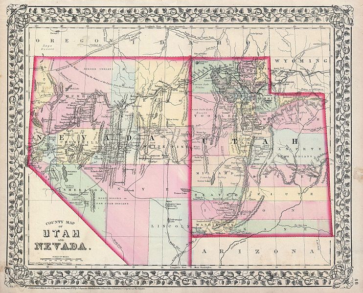
| Samuel Augustus Mitchell: County Map of Utah and Nevada.
( |
||||||||||||||||||||
|---|---|---|---|---|---|---|---|---|---|---|---|---|---|---|---|---|---|---|---|---|
| Artist |
|
|||||||||||||||||||
| Title |
County Map of Utah and Nevada. |
|||||||||||||||||||
| Description |
English: A beautiful example of S. A. Mitchell Jr.’s 1872 map of Utah and Nevada. Super detail regarding American Indian Tribes, mining areas, and emigrant trails. Denotes both political and geographical details. One of the most attractive American atlas maps of this region to appear in the mid 19th century. Features the vine motif border typical of Mitchell maps from the 1866 - 1882 period. Prepared by W. H. Gamble for inclusion as plate no. 48 in the 1872 issue of Mitchell’s New General Atlas . Dated and copyrighted, “Entered according to Act of Congress in the Year 1872 by S. A. Mitchell Jr. in the Clerk’s Office of the District Court of the U.S. for the Eastern District of Pennsylvania. |
|||||||||||||||||||
| Date | 1872 (dated) | |||||||||||||||||||
| Dimensions | height: 11.5 in (29.2 cm); width: 14.5 in (36.8 cm) | |||||||||||||||||||
| Accession number |
Geographicus link: UTNV-mitchell-1872 |
|||||||||||||||||||
| Source/Photographer |
Mitchell's New General Atlas, (1872 edition)
|
|||||||||||||||||||
| Permission (Reusing this file) |
|
|||||||||||||||||||
File history
Click on a date/time to view the file as it appeared at that time.
| Date/Time | Thumbnail | Dimensions | User | Comment | |
|---|---|---|---|---|---|
| current | 16:30, 16 March 2011 | | 4,000 × 3,231 (3.34 MB) | BotMultichill | {{subst:User:Multichill/Geographicus |link=http://www.geographicus.com/P/AntiqueMap/UTNV-mitchell-1872 |product_name=1872 Mitchell Map of Utah and Nevada |map_title=County Map of Utah and Nevada. |description=A beautiful example of S. A. Mitchell Jr.’s |
File usage
No pages on the English Wikipedia use this file (pages on other projects are not listed).