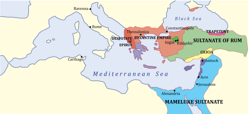
Size of this PNG preview of this SVG file: 800 × 367 pixels. Other resolutions: 320 × 147 pixels | 640 × 293 pixels | 1,024 × 469 pixels | 1,280 × 587 pixels | 2,560 × 1,173 pixels | 925 × 424 pixels.
Original file (SVG file, nominally 925 × 424 pixels, file size: 704 KB)
File history
Click on a date/time to view the file as it appeared at that time.
| Date/Time | Thumbnail | Dimensions | User | Comment | |
|---|---|---|---|---|---|
| current | 17:08, 10 December 2011 |  | 925 × 424 (704 KB) | Hoodinski | == {{int:filedesc}} == {{Information |Description={{en|Middle East c. 1263. KEY: *Dark Green: Ottoman domain by 1300's, dotted line indicates conquests up to 1326 *Purple: Byzantine Empire (successor of Nicaean Empire) *Light Green: Turk lands, nominal va |
File usage
The following pages on the English Wikipedia use this file (pages on other projects are not listed):
Global file usage
The following other wikis use this file:
- Usage on azb.wikipedia.org
- Usage on az.wikipedia.org
- Usage on ba.wikipedia.org
- Usage on bn.wikipedia.org
- Usage on cs.wikipedia.org
- Usage on el.wikipedia.org
- Usage on et.wikipedia.org
- Usage on id.wikipedia.org
- Usage on it.wikipedia.org
- Usage on ko.wikipedia.org
- Usage on mk.wikipedia.org
- Usage on ms.wikipedia.org
- Usage on pl.wikipedia.org
- Usage on rm.wikipedia.org
- Usage on ru.wikipedia.org
- Usage on sk.wikipedia.org
- Usage on sl.wikipedia.org
- Usage on sr.wikipedia.org
- Usage on tr.wikipedia.org
- Usage on uk.wikipedia.org
- Usage on vi.wikipedia.org
- Usage on zh.wikipedia.org


