Added {{Notability}} tag: AfD was no-consensus, with a majority to delete, so notability doubtful Tag: Twinkle |
Selfstudier (talk | contribs) Undid revision 990096365 by 11Fox11 (talk) The Afd did not delete, dyk is in process, meanwhile notabilty is presumed. |
||
| Line 1: | Line 1: | ||
{{ |
{{use dmy dates|date=November 2020}} |
||
{{use dmy dates|date=November 2020}} |
|||
{{multiple image |
{{multiple image |
||
| image1 = Oslo II Accord map of Area A and B.jpg |
| image1 = Oslo II Accord map of Area A and B.jpg |
||
Revision as of 20:20, 22 November 2020


The West Bank bantustans,[a] or West Bank cantons, figuratively described as the Palestine Archipelago,[b][1][2][3] are the proposed noncontiguous enclaves for the Palestinian population of the West Bank under a variety of US and Israeli-led proposals to end the Israeli-Palestinian conflict.[c][4] The process of creating the fragmented Palestinian zones has been described as "encystation" by Professor Glenn Bowman, Emeritus Professor of Politics and International Relations at Kent University,[5] and as "enclavization" by Professor Ghazi Falah at the University of Akron.[6][7]
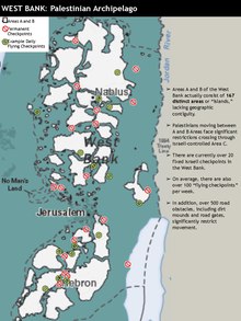
The terms have also been used to describe Areas A and B under the 1995 Oslo II Accord, and the similar but less formal situation between 1967 and 1995.[8] Under the terms of the Oslo Accords, the area of the West Bank controlled by the Palestinian National Authority is composed of 165 "islands".[d] Shari Motro has referred to the Oslo accord maps as the Swiss Cheese map.[9]
It has been argued that the bantustan structure underpins many of Israeli "final status" proposals for the conflict, including Allon Plan, the WZO plan, Menachem Begin's plan, Benjamin Netanyahu's "Allon Plus" plan, 2000 Camp David Summit and Ariel Sharon's proposals.[e] and most recently, the Trump peace plan.
Debate has continued as to whether the existing or proposed arrangements are contiguous or noncontiguous.
History
1967-1995

After the 1967 Six-Day War, a small group of officers and senior Israeli officials advocated for Israel, on its own, to create a small externally controlled Palestinian area or "canton", in the north of the West Bank. Policymakers did not implemente this cantonal plan at the time. Defense minister Moshe Dayan said that Israel should keep the West Bank and Gaza Strip.[f] In early 1968, Yigal Allon, the Israeli minister after whom the 1967 Allon Plan is named, proposed reformulating his plan by transferring some Palestinian areas back to Jordan, for fear that the resulting Palestinian areas "would be identified as... some kind of South African bantustan".[10]
According to former Israeli ambassador and vice president of Tel Aviv University Avi Primor, writing in 2002, in the top echelons of the Israeli security establishment in the 1970s and 1980s there was widespread empathy for South Africa's apartheid system, and were particularly interested in that country's resolution of the demographic issue by inventing bantustan "homelands" for various groups of the indigenous black population.[g] Pro-Palestinian circles and scholars, despite the secrecy of the tacit alliance between Israel and South Africa, were familiar with ongoing arrangements between the two in military and nuclear matters, though the thriving cooperation between Israel and the Bantustans themselves was a subject that remained neglected until recently, when South Africa's archives began to be opened up.[11] By the early 1970s, Arabic-language magazines began to compare the Israeli proposals for a Palestinian autonomy to the Bantustan strategy of South Africa.[12]
In late 1984 some embarrassment was caused when the Israeli settlement of Ariel in the West Bank paired itself as a sister city with Bisho, the "capital" of the ostensibly independent Bantustan of Ciskei. Shortly afterwards, Simon Peres the new Prime Minister of a Labour-Likud national coalition government, condemned apartheid as an "idiotic system".[13]
Oslo Accord and subsequent peace plans
The 1995 Oslo Accords formalized the fragmentation of the West Bank, allotting to the Palestinians over 60 disconnected islands;[h] by the end of 1999 the West Bank had been divided into 227 separate entities, most of which were no more than 2 square kilometres (0.77 sq mi) (about half the size of New York's Central Park).[i] These areas, comprising what is known as Area A (c.1005km2; 17.7% of the West Bank) and Area B (c.1035km2; 18.3% of the West Bank), formalized the legal limitation to urban expansion of Palestinian populated areas outside of these fragments.[14] These arrangements were, however, agreed at Oslo to be temporary, with the West Bank to "be gradually transferred to Palestinian jurisdiction in accordance" by 1997; no such transfers were made.[15]
The Oslo map has been referred to as the Swiss Cheese map.[9] The Palestinian negotiators at Oslo were not shown the Israeli map until 24 hours before the agreement was due to be signed; Yasser Arafat was quoted by Uri Savir, the Israeli chief negotiator at Oslo, as follows: "Arafat glared at [the map] in silence, then sprang out of his chair and declared it to be an insufferable humiliation. "These are cantons! You want me to accept cantons! You want to destroy me!""[9]
Professor Shari Motro, then an Israeli officer in the Oslo delegation, described in 2005 part of the story behind the maps:
Some people claim that the Oslo process was deliberately designed to segregate Palestinians into isolated enclaves so that Israel could continue to occupy the West Bank without the burden of policing its people. If so, perhaps the map inadvertently revealed what the Israeli wordsmiths worked so diligently to hide. Or perhaps Israel's negotiators purposefully emphasized the discontinuity of Palestinian areas to appease opposition from the Israeli right, knowing full well that Arafat would fly into a rage. Neither is true. I know, because I had a hand in producing the o≤cial Oslo II map, and I had no idea what I was doing. Late one night during the negotiations, my commander took me from the hotel where the talks were taking place to an army base, where he led me to a room with large fluorescent light tables and piles of maps everywhere. He handed me some dried-out markers, unfurled a map I had never seen before, and directed me to trace certain lines and shapes. Just make them clearer, he said. No cartographer was present, no graphic designer weighed in on my choices, and, when I was through, no Gilad Sher reviewed my work. No one knew it mattered.[16]
After the ensuing Wye River Accords Noam Chomsky argued that the situation envisaged still differed from the historical South African model in that Israel did not subsidize the fragmented territories it controlled, as South Africa did, leaving that to international aid donors; and secondly, despite exhortations from the business community, it had, at that period, failed to set up maquiladoras or industrial parks to exploit cheap Palestinian labour, as had South Africa with the bantustans. [17] He did draw an analogy however between the two situations by claiming that the peace negotiations had led to a corrupt elite, the Palestinian Authority, playing a role similar to that of the black leadership appointed by South Africa to administer their Bantustans.[18]
Many observers, including Edward Said, Norman Finkelstein and seasoned Israeli analysts such as Meron Benvenisti were highly critical of the arrangements, with Benvenisti concluding that the Palestinian self-rule sketched out in the agreements was little more than a euphemism for Bantustanization.[19][20] Defenders of the agreements made in the 1990s between Israel and the PLO rebuffed criticisms that the effect produced was similar to that of South Africa's apartheid regime, by noting that, whereas the Bantustan structure was never endorsed internationally, the Oslo peace process's memoranda had been underwritten and supported by an international concert of nations, both in Europe, the Middle East and by the Russian Federation. [18]
The failure of the subsequent 2000 Camp David Summit has been blamed, amongst other factors, on the inability to unwind the bantustans; as Israeli journalist Ze'ev Schiff stated: "the prospect of being able to establish a viable state was fading right before [the Palestinians'] eyes. They were confronted with an intolerable set of options: to agree to the spreading occupation... or to set up wretched Bantustans, or to launch an uprising."[21]
Ariel Sharon's disengagement plan
Ariel Sharon's withdrawal of Israeli settlements from Gaza was widely interpreted as part of a broader strategy of bantustanization connected to the creation of the Separation Barrier. His contention was that the Apartheid system's Bantustan model was the appropriate model for the conflict,[22] and explicitly mentioned in 2003 that in constructing a "map of a (future) Palestinian state," he had in mind the model of South Africa's Bantustan system.[j] Not only was the Gaza Strip to be reduced to a bantustan, but the model there, according to Meron Benvenisti, was to be transposed to the West Bank by ensuring, simultaneously, that the Wall itself broke up into three fragmented entities Jenin-Nablus, Bethlehem-Hebron and Ramallah.[k][23]
Avi Primor in 2002 described the implications of the plan: "Without anyone taking notice, a process is underway establishing a "Palestinian state" limited to the Palestinian cities, a "state" comprised of a number of separate, sovereign-less enclaves, with no resources for self-sustenance."[24] Commenting on these plans in 2006, Elisha Efrat, Professor of urban geography at TAU argued that any state created on these fragmented divisions would be neither economically viable nor amenable to administration.[l]
Bush and Obama
In 2008, the last year of his presidency, George W. Bush stated "Swiss cheese isn't going to work when it comes to the outline of a state. To be viable, a future Palestinian state must have contiguous territory."[26]
In 2016, the last year of his presidency, Barack Obama and John Kerry discussed a number of detailed maps showing the fragmentation of the Palestinian areas. Advisor Ben Rhodes said that "the President was shocked to see how "systematic" the Israelis had been at cutting off Palestinian population centers from one another." These finding were discussed with the Israeli government; the Israelis "never challenged those findings". Obama's realization was reported to be the reason that he abstained on the United Nations Security Council Resolution 2334 which condemned the settlements.[27]
According to Haaretz's Chemi Shalev, in a speech marking the 50th anniversary of the Six-Day War, "Netanyahu thus envisages not only that Palestinians in the West Bank will need Israeli permission to enter and exit their "homeland," which was also the case for the Bantustans, but that the IDF will be allowed to continue setting up roadblocks, arresting suspects and invading Palestinian homes, all in the name of "security needs"."[28]
Trump peace plan
The 2020 Trump peace plan proposed splitting a possible "State of Palestine" into five zones:[29]
- A reduced Gaza Strip connected by a road to two uninhabited districts in the Negev desert;
- Part of the southern West Bank;
- A central area around Ramallah, almost trisected by a number of Israeli settlements;
- A northern area including Nablus, Jenin, and Tulkarm;
- A small zone including Qalqilya, surrounded by Israeli settlements.
According to Professor Ian Lustick, the "appellation "State of Palestine" applied to this archipelago of Palestinian-inhabited districts is not to be taken any more seriously than the international community took apartheid South Africa's description of the bantustans of Transkei, Bophuthatswana, Venda, and Ciskei as "independent nation-states.""[29]
When the plan emerged, Yehuda Shaul argued that the proposals were remarkably similar to the details set forth both in the 1979 Drobles Plan, written for the World Zionist Organization and entitled Master Plan for the Development of Settlements in Judea and Samaria, 1979–1983, and key elements of the earlier Allon Plan, aimed at ensuring Jewish settlement in the Palestinian territories, while blocking the possibility that a Palestinian state could ever emerge.[30][m]
The plan in principle contemplates a future Palestinian state, "shrivelled to a constellation of disconnected enclaves, following Israeli annexation.", while a group of UN human rights experts said "What would be left of the West Bank would be a Palestinian Bantustan, islands of disconnected land completely surrounded by Israel and with no territorial connection to the outside world."[32] [33]
Names
The name "cantons" is considered to imply a neutral concept where political implications are left to be determined, whereas the name "bantustans" is considered to imply economic and political implications and the lack of meanginful sovereignty.[n] The name "islands" or "archipelago" is considered to communicate how the infrastructure of the Israeli occupation of the West Bank has disrupted contiguity between Palestinian areas.[34]
Notes
- ^ Also contracted as "Palutustans".'The experience of the past four decades puts a question mark over this assumption. If a Palestinian state is not established, Israel will most likely continue to administer the area, possibly allotting crumbs of sovereignty to Palestinian groups in areas that will continue to function as "Palutustans" (Palestinian Bantustans)." (Yiftachel 2016, p. 320)
- ^ "In 2009, French artist Julien Bousac designed a map of the West Bank titled "L'archipel de Palestine orientale, " or "The Archipelago of Eastern Palestine"... Bousac's map illustrates — via a military and a tourist imaginary — how the US-brokered Oslo Accords fragmented the West Bank into enclaves separated by checkpoints and settlements that maintain Israeli control over the West Bank and circumscribe the majority of the Palestinian population to shrinking Palestinian city and village centers." (Kelly 2016, pp. 723–745)
- ^ "Faced with widely drawn international parallels between the West Bank and the Bantustans of apartheid South Africa, senior figures in Mr Netanyahu's Likud party have begun to admit the danger.' (FT 2013)
- ^ "90 percent of the population of the West Bank was divided into 165 islands of ostensible PA control." (Thrall 2017, p. 144)
- ^ 'Israel responded to the second intifada with a strategy of collective punishment aimed at a return to the logic of Oslo, whereby a weak Palestinian leadership would acquiesce to Israeli demands and a brutalized population would be compelled to accept a "state" made up of a series of Bantustans. Though the language may have changed slightly, the same structure that has characterized past plans remains. The Allon plan, the WZO plan, the Begin plan, Netanyahu's "Allon Plus" plan, Barak's "generous offer," and Sharon's vision of a Palestinian state all foresaw Israeli control of significant West Bank territory, a Palestinian existence on minimal territory surrounded, divided, and, ultimately, controlled by Israel, and a Palestinian or Arab entity that would assume responsibility for internal policing and civil matters.' (Beinin & Stein 2006, p. 346)
- ^ 'During the early days of the occupation a handful of senior Israeli officials and army officers advocated unilateral plans for a Palestinian satellite mini-state, autonomous region, or "canton" — Bantustan actually — in the northern half of the West Bank, but the policymakers would have none of this.' (Raz 2020, p. 278)
- ^ "Many in the top echelons of the security establishment in the 1970s and 1980s had a warm spot in their hearts for the white apartheid regime in South Africa that was derived not only from utilitarian interests, but also from sympathy for the white minority rulers in that country. One of the elements of the old South African regime that stirred much interest in Israel remains current to this day: To seemingly solve the demographic problem that troubled the white South Africans (that is, to hang on to all of South Africa without granting equal rights, civil rights and the vote to blacks), the South African regime created a fiction known by the name Bantustans, later changed to Homelands." (Primor 2002)
- ^ "In any case, what was on offer at Oslo was a territorially discontinuous Palestinian Bantustan (divided into over sixty disconnected fragments) that would have had no control over water resources, borders, or airspace, much less an independent economy, currency, or financial system, and whose sovereignty, nominal as it was, would be punctuated by heavily fortified Israeli colonies and an autonomous Jewish road network, all of which would be effectively under Israeli army control. Even this, however, was never realized." (Makdisi 2005, pp. 443–461)
- ^ "By December 1999, the Gaza Strip had been divided into three cantons and the West Bank into 227, the majority of which were no larger than two square kilometers in size. Both areas were effectively severed from East Jerusalem. While Palestinians maintained control over many of the cantons and were promised authority over more if not most, Israel maintained jurisdiction over the land areas in between the cantons, which in effect gave Israel control over all the land and its disposition. Hence, the actual amount of land under Palestinian authority proved far less important than the way that land was arranged and controlled." (Roy 2004, pp. 365–403)
- ^ 'In 2003, Prime Minister Ariel Sharon revealed that he relied on South Africa's Bantustan model in constructing a possible "map of a Palestinian state"." (Feld 2014, p. 99,138)
- ^ "with breathtaking daring, Sharon submits a plan that appears to promise the existence of a "Jewish democratic state" via "separation", "the end of the conquest", the "dismantling of settlements" – and also the imprisonment of some 3 million Palestinians in bantustans. This is an "interim plan" that is meant to last forever. The plan will last, however, only as long as the illusion is sustained that "separation" is a means to end the conflict.' (Benvenisti 2004)
- ^ 'It is quite clear that a Palestinian State with so many territorial enclaves will not be able to manage economic functions and administration. Even if its sovereign territory were greater, and even if some of the enclaves were connected into a continued territorial unity, the main communications arteries that are under Israeli dominance running from north to south and from west to east, and those along the Judean Desert that are under Israeli dominance, might perpetuate their spatial fragmentation.'[25]
- ^ The International Fact-Finding Mission on Israeli Settlements noted that "Various sources refer to settlement master plans, including the Allon Plan(1967), the Drobles Plan(1978)–later expanded as the Sharon Plan(1981)– and the Hundred Thousand Plan(1983). Although these plans were never officially approved, they have largely been acted upon by successive Governments of Israel. The mission notes a pattern whereby plans developed for the settlements have been mirrored in Government policy instruments and implemented on the ground."[31]
- ^ Ariel Sharon, Israel's Prime Minister since 2001, had long contended that the Bantustan model, so central to the apartheid system, is the most appropriate to the present Israeli-Palestinian conflict. Others, by contrast, have maintained that the Palestinian territories have been transformed into cantons whose final status is still to be determined. The difference in terminology between cantons and Bantustans is not arbitrary though. The former suggests a neutral territorial concept whose political implications and contours are left to be determined. The latter indicates a structural development with economic and political implications that put in jeopardy the prospects for any meaningfully sovereign viable Palestinian state. It makes the prospects for a binational state seem inevitable, if most threatening to the notion of ethnic nationalism.' (Farsakh 2005, p. 231)
Citations
- ^ Barak 2005, pp. 719–736.
- ^ Baylouny 2009, pp. 39–68.
- ^ Peteet 2016, pp. 247–281.
- ^ Chaichian 2013, pp. 271–319.
- ^ Bowman 2007, pp. 127–135.
- ^ Falah 2005, pp. 1341–1372.
- ^ Taraki 2008, pp. 6–20.
- ^ Harris 1984, pp. 169–189.
- ^ a b c Motro 2005, p. 46.
- ^ Gorenberg 2006, p. 153.
- ^ Lissoni 2015, pp. 53–55.
- ^ Clarno 2009, pp. 66–67.
- ^ Hunter 1986, p. 58.
- ^ Moghayer, Daget & Wang 2017, p. 4.
- ^ Niksic, Eddin & Cali 2014, p. 1.
- ^ Motro 2005, p. 47.
- ^ Chomsky & Barsamian 2001, p. 92.
- ^ a b Sabel 2011, p. 25.
- ^ Finkelstein 2003, p. 177.
- ^ McMahon 2010, pp. 23–24.
- ^ Slater 2001, pp. 171–199.
- ^ Farsakh 2005, p. 231.
- ^ Machover 2012, p. 55.
- ^ Primor 2002.
- ^ Efrat 2006, p. 199.
- ^ Evening Standard 2008.
- ^ Entous 2018.
- ^ Shalev 2017.
- ^ a b Lustick 2005, p. 23.
- ^ Shaul 2020.
- ^ UNHCR 2013a, pp. 6–7.
- ^ FT 2020.
- ^ UNHRC 2020b.
- ^ Kelly 2016, pp. 723–745.
Sources
- Alissa, Sufyan (4 July 2013). "6:The economics of an independent Palestine". In Hilal, Jamil (ed.). Where Now for Palestine?: The Demise of the Two-State Solution. Zed Books Ltd. ISBN 978-1-84813-801-8.
{{cite book}}: Cite has empty unknown parameter:|1=(help)
- Barak, Oren (November 2005). "The Failure of the Israeli-Palestinian Peace Process, 1993-2000". Journal of Peace Research. 42 (6): 719–736. doi:10.1177/0022343305057889. JSTOR 30042415. S2CID 53652363.
- Baylouny, Anne Marie (September 2009). "Fragmented Space and Violence in Palestine". International Journal on World Peace. 26 (3): 39–68. JSTOR 20752894.
- Beinin, Joel; Stein, Rebecca L. (2006). The Struggle for Sovereignty: Palestine and Israel, 1993-2005. Stanford University Press. ISBN 978-0-8047-5365-4.
- Benvenisti, Meron (26 April 2004). "Bantustan Plan for an apartheid Israel". The Guardian.
- Bowman, Glenn (2007). "Israel's wall and the logic of encystation: Sovereign exception or wild sovereignty?". Focaal-European Journal of Anthropology (50): 127–136.
- Chaichian, Mohammed (2013). "Bantustans, Maquiladoras, and the Separation Barrier Israeli Style". Empires and Walls: Globalization, Migration, and Colonial Domination. BRILL. pp. 271–319. ISBN 978-9-004-26066-5.
- Chomsky, Noam; Barsamian, David (2001). Propaganda and the Public Mind: Conversations with Noam Chomsky. Pluto Press. ISBN 978-0-745-31788-5.
- Clarno, Andrew James (2009). The Empire's New Walls: Sovereignty, Neo-liberalism, and the Production of Space in Post-apartheid South Africa and Post-Oslo Palestine/Israel (Thesis). pp. 66–67. hdl:2027.42/127105. ISBN 978-1-244-00753-6.
- Efrat, Elisha (2006). The West Bank and Gaza Strip: A Geography of Occupation and Disengagement. Routledge. ISBN 978-1-134-17217-7.
- Entous, Adam (9 July 2018). "The Maps of Israeli Settlements That Shocked Barack Obama". New Yorker Magazine.
- Falah, Ghazi-Walid (2005). "The Geopolitics of 'Enclavisation' and the Demise of a Two-State Solution to the Israeli-Palestinian Conflict". Third World Quarterly. 26 (8): 1341–1372. doi:10.1080/01436590500255007. JSTOR 4017718. S2CID 154697979.
- Farsakh, Leila (Spring 2005). "Independence, Cantons, or Bantustans: Whither the Palestinian State?". Middle East Journal. 59 (2): 230–245. doi:10.3751/59.2.13. JSTOR 4330126.
- Feld, Marjorie N. (2014). Nations Divided: American Jews and the Struggle over Apartheid. Springer. ISBN 978-1-137-02972-0.
- Finkelstein, Norman G. (2003). Image and Reality of the Israel-Palestine Conflict (2nd ed.). Verso. ISBN 978-1-859-84442-7.
- "George Bush pledges for Middle East peace within a year". Evening Standard. 11 January 2008.
- Gorenberg, Gershom (2006). The Accidental Empire: Israel and the Birth of the Settlements, 1967-1977. Henry Holt and Company. ISBN 978-1-466-80054-0.
- Harris, Brice, Jr (Summer 1984). "The South Africanization of Israel". Arab Studies Quarterly. 6 (3): 169–189. JSTOR 41857718.
{{cite journal}}: CS1 maint: multiple names: authors list (link) - Hunter, Jane (Spring 1986). "Israel and the Bantustans". Journal of Palestine Studies. 15 (3): 53–89. JSTOR 2536750.
- Kelly, Jennifer Lynn (September 2016). "Asymmetrical Itineraries: Militarism, Tourism, and Solidarity in Occupied Palestine" (PDF). American Quarterly. 68 (3): 723–745.
- Le More, Anne (31 March 2008). International Assistance to the Palestinians after Oslo: Political guilt, wasted money. Routledge. ISBN 978-1-134-05232-5.
- Lissoni, Arianna (2015). "Apartheid's Little Israel: Bophuthatswana". In Jacobs, Sean; Soske, Jon (eds.). Apartheid Israel: The Politics of an Analogy. Haymarket Books. pp. 53–66. ISBN 978-1-608-46519-4.
- Lustick, Ian (2005). "The One-State Reality: Reading the Trump-Kushner Plan as a Morbid Symptom". The Arab World Geographer. 23 (1): 23.
- Machover, Moshé (2012). Israelis and Palestinians: Conflict and Resolution. Haymarket Books. ISBN 978-1-608-46148-6.
- Makdisi, Saree (2005). "Said, Palestine, and the Humanism of Liberation". Critical Inquiry. 31 (2): 443–461. JSTOR 430974.
- McMahon, Sean F. (2010). The Discourse of Palestinian-Israeli Relations: Persistent Analytics and Practices. Routledge. ISBN 978-1-135-20204-0.
- Moghayer, Taher J.T.; Daget, Yidnekachew Tesmamma; Wang, Xingping (2017). "Challenges of urban planning in Palestine". IOP Conference Series: Earth and Environmental Science. 81. 2nd International Conference on Materials Science, Energy Technology and Environmental Engineering (MSETEE 2017): 1–5.
- Motro, Shari (2005). "Lessons From the Swiss Cheese Map". Legal Affairs: 46–50.
- Niksic, Orhan; Eddin, Nur Nasser; Cali, Massimiliano (10 July 2014). Area C and the Future of the Palestinian Economy. World Bank Publications. ISBN 978-1-4648-0196-9.
{{cite book}}: Invalid|ref=harv(help) - Peteet, Julie (Winter 2016). "The Work of Comparison: Israel/Palestine and Apartheid". Anthropological Quarterly. 89 (1): 247–281. doi:10.1353/anq.2016.0015. JSTOR 43955521. S2CID 147128703.
- Primor, Avi (18 September 2002). "Sharon's South African strategy". Haaretz.
- Raz, Avi (2020). "Dodging the Peril of Peace: Israelk and the Arabs in the Aftermath of the 1967 War". In Hanssen, Jens; Ghazal, Amal N. (eds.). The Oxford Handbook of Contemporary Middle-Eastern and North African History. Oxford University Press. pp. 269–291. ISBN 978-0-199-67253-0.
- Roy, Sara (2004). "The Palestinian-Israeli Conflict and Palestinian Socioeconomic Decline: A Place Denied". International Journal of Politics, Culture, and Society. 17 (3): 365–403. doi:10.1023/B:IJPS.0000019609.37719.99. JSTOR 20007687. S2CID 145653769.
- "Settler policy imperils Israel's foundations". Financial Times. 21 February 2013.
- "Israel's annexation plan: the 'existential threat' to Palestinian dreams". Financial Times. 17 June 2020.
- Sabel, Robbie (Fall 2011). "The Campaign to Delegitimize Israel with the False Charge of Apartheid". Jewish Political Studies Review. 23 (3/4): 18–31. JSTOR 41575857.
- Shalev, Chemi (6 June 2017). "Netanyahu's Blueprint for a Palestinian Bantustan". Haaretz.
{{cite news}}: Invalid|ref=harv(help) - Shaul, Yehuda (11 February 2020). "Trump's Middle East Peace Plan Isn't New. It Plagiarized a 40-Year-Old Israeli Initiative". Foreign Policy.
{{cite news}}: Invalid|ref=harv(help) - Slater, Jerome (2001). "What Went Wrong? The Collapse of the Israeli-Palestinian Peace Process". Political Science Quarterly. 116 (2): 171–199. doi:10.2307/798058. JSTOR 798058.
- Taraki, Lisa (Summer 2008). "Enclave Micropolis: The Paradoxical Case of Ramallah/Al-Bireh" (PDF). Journal of Palestine Studies. 37 (4): 6–20. doi:10.1525/jps.2008.37.4.6.
- Thrall, Nathan (2017). The Only Language They Understand: Forcing Compromise in Israel and Palestine. Henry Holt and Company. ISBN 978-1-62779-710-8.
- Report of the independent international fact-finding mission to investigate the implications of the Israeli settlements on the civil, political, economic, social and cultural rights of the Palestinian people throughout the Occupied Palestinian Territory, including East Jerusalem (PDF) (Report). UNHCR. 7 February 2013. pp. 6–7.
- "Israeli annexation of parts of the Palestinian West Bank would break international law – UN experts call on the international community to ensure accountability". UNHRC. 16 June 2020.
- Yiftachel, Oren (2016). "Between One and Two: Apartheid or Confederation for Israel/Palestine?". In Ehrenberg, John; Peled, Yoav (eds.). Israel and Palestine: Alternative Perspectives on Statehood. Rowman and Littlefield. pp. 305–336. ISBN 978-1-442-24508-2.