LaGrange Historic District | |
 Colonel A. C. Davis House, built in 1887 | |
| Location | Roughly bounded by N. Caswell, E. James, N. Carey, E. Washington, S. Caswell, W. Washington, and Forbes Sts. La Grange, North Carolina |
|---|---|
| Coordinates | 35°18′20″N 77°47′30″W / 35.30556°N 77.79167°W |
| Architectural style | Queen Anne, Bungalow/Craftsman |
| NRHP reference No. | 00000458[1] |
| Added to NRHP | May 11, 2000 |
The La Grange Historic District is a national historic district located ub La Grange, North Carolina, United States. The district, encompassing 225 buildings and 1 structure, includes the historic commercial, residential, and industrial center of La Grange. The buildings include notable examples of Queen Anne and Bungalow/American Craftsman style architecture and date between the 1850s and the 1930s. Located in the district is the separately listed La Grange Presbyterian Church. Other notable buildings include the Sutton-Kinsey House (c. 1898), Walter Pace House (c. 1900), Sutton-Fields House (c. 1850), Colonel A. C. Davis House (1887), Rouse Banking Company Building (1908), LaGrange Elementary School, and the Hardy-Newsome Industrial Complex. It was added to the National Register of Historic Places in May 2000.
Geography

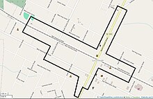
The northern end of the historic district begins just above the intersection of Hadley Street and North Caswell Street. The boundary heads south, running behind the property lines of buildings along the east side of North Cameron Street. The boundary then heads east, behind buildings facing East Railroad Street and ends before North Carey Street. It then crosses the street and railroad tracks to include buildings on the south side of East Railroad Street. This continues until reaching the properties along South Cameron Street, where the boundary heads south. At East Boundary Street, the boundary crosses the road and heads south for around half a block.[2]
It then heads slightly west before turning north again, running behind the property lines of buildings on West Boundary Street, until just past the intersection with South Charles Street. The boundary turns north on South Charles Street and takes a turn west to include the buildings along West Railroad Street. The boundary goes west until crossing School Street. It crosses West Railroad Street and includes buildings that are on the north side of the railroad tracks. After heading east on West Railroad Street, the boundary stops behind the property lines of buildings on North Caswell Street and heads north, stopping on the other side of Hadley Street, where the boundary began.[2]
See also
References
- ^ "National Register Information System". National Register of Historic Places. National Park Service. July 9, 2010.
- ^ a b Alexander, Frances P.; Mattson, Richard L.; Gatza, Mary Beth (August 23, 1999). "National Register of Historic Places Registration Form" (PDF). North Carolina Office of Archives and History. Retrieved November 15, 2014.
Externa links
 Media related to La Grange Historic District (North Carolina) at Wikimedia Commons

