| Richmond temperate forests | |
|---|---|
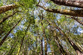
 Silver beech (Nothofagus menziesii) in Nelson Lakes National Park | |
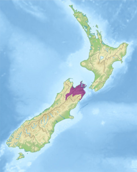
 Ecoregion territory (in purple) | |
| Ecology | |
| Realm | Australasian |
| Biome | temperate broadleaf and mixed forests |
| Borders | |
| Geography | |
| Area | 12,836 km2 (4,956 sq mi) |
| Country | New Zealand |
| Regions | |
| Coordinates | 41°36′S 173°30′E / 41.6°S 173.5°E |
| Conservation | |
| Protected | 4,836 km² (38%)[1] |
The Richmond temperate forests is an ecoregion covering the northern part of New Zealand's South Island. [2] [3] [4]
Location and description[edit]
This area includes the mountain valleys of the Kaikōura Ranges with its high peak at the 2880-metre Mount Tapuaenuku, while to the south lies the beech-covered Spencer Range, and to the north and east lies open land running down to the Marlborough Sounds at the tip of the island. The wide valleys of the Wairau and Awatere rivers divide the region.
The climate is characterised by a hot summer and a cold, dry winter.[5]
Flora[edit]
The native flora of this north country is Nothofagus beech forest with red beech (Nothofagus fusca) and silver beech (N. menziesii) in the lower, warmer, more fertile areas and hard beech (N. truncata) in the more exposed areas. Notable plants include the sedge Carex uncifolia.
Fauna[edit]
The black-eyed gecko (Hoplodactylus kahutarae), New Zealand’s only alpine gecko is endemic to the north of South island, which is also home to the vulnerable scree skint (Oligosoma waimatense) and four species of giant weta including Kaikoura giant weta (Deinacrida parva) and the Kaikoura Ranges weta (Deinacrida elegans). The islands in the Marlborough Sounds have more endemic species of their own.
Threats and preservation[edit]
There are a number of protected areas along the Marlborough Sounds (on the islands in particular) and inland in the Nelson Lakes National Park and Mount Richmond Forest Park.
References[edit]
- ^ Dinerstein, Eric; Olson, David; et al. (June 2017). "An Ecoregion-Based Approach to Protecting Half the Terrestrial Realm". BioScience. 67 (6): 534–545. doi:10.1093/biosci/bix014. PMC 5451287. PMID 28608869.
{{cite journal}}: CS1 maint: date and year (link) Supplemental material 2 table S1b. - ^ "Map of Ecoregions 2017". Resolve. Retrieved August 20, 2021.
- ^ "Richmond temperate forests". Digital Observatory for Protected Areas. Retrieved August 20, 2021.
- ^ "Richmond temperate forests". The Encyclopedia of Earth. Retrieved August 20, 2021.
- ^ "Northern part of New Zealand's South Island". Terrestrial Ecoregions. World Wildlife Fund.