Introduction
 Western Australia (WA) is a state of Australia occupying the western third of the land area of the Australian continent.[text–source integrity?] It is bounded by the Indian Ocean to the north and west, the Southern Ocean to the south, the Northern Territory to the north-east, and South Australia to the south-east. With a total land area of 2,527,013 square kilometres (975,685 sq mi), Western Australia is Australia's largest state as well as the second-largest subdivision of any country on Earth, surpassed only by the Sakha Republic in eastern Russia. Western Australia has a diverse range of climates, including tropical conditions in the Kimberley, deserts in the interior (including the Great Sandy Desert, Little Sandy Desert, Gibson Desert, and Great Victoria Desert) and a Mediterranean climate on the south-west and southern coastal areas. the state has 2.91 million inhabitants—11 percent of the national total. Over 90 percent of the state's population live in the south-west corner and around 80 percent live in the state capital Perth, leaving the remainder of the state sparsely populated. The Trans-Australian Railway and the Eyre Highway traverse the Nullarbor Plain in the state's south-east, providing the principal connection between Western Australia and the population centres in the eastern states. (Full article...)
|


(Northern
Territory) |
 Good articles -
-

Aubin Grove railway station is a suburban railway station serving Atwell, Aubin Grove, Hammond Park and Success, which are suburbs of Perth, Western Australia. It is on the Mandurah line, which is part of the Transperth network, and is located immediately north of Russell Road in the median of the Kwinana Freeway. It has two platform faces on a singular island platform, which is linked to either side of the freeway by a pedestrian overpass. Services run every 10 minutes during peak and every 15 minutes between peak. The journey to Perth station is 23.8 kilometres (14.8 mi) and takes 21 minutes. The station has a bus interchange with four bus stands and seven regular bus routes.
Construction of the station was promised by both major political parties ahead of the 2013 Western Australian state election. A tender was released for the station's construction in July 2014, with a projected cost of A$80 million for the whole project, including the purchase of two Transperth B-series trains. The design contract was awarded in February 2015 to a joint venture between Coniglio Ainsworth Architects and M. P. S. Architects. The scope of the project was broadened in April 2015 to include the widening of the Russell Road bridge over the freeway, which increased the project budget to $105 million. Construction on the station began in March 2016, and it was opened on 23 April 2017, with the final cost being $125 million. (Full article...) -
Benjamin John Small (born 11 June 1988) is an Australian politician. He was selected to serve as a senator for Western Australia, representing the Liberal Party, to fill a casual vacancy following Mathias Cormann's resignation. His first term lasted from November 2020 until his April 2022 resignation, and he resumed his term in May after being nominated to replace himself. Small was unsuccessful in his re-election bid in the 2022 federal election and his term as senator concluded on 30 June 2022.
Small studied nautical science, marine operations, and business management. He worked in marine transport and logistics for several energy and resource companies, with his holdings in those criticised as a potential conflict of interest. Before becoming a senator, he was active in grassroots politics, and unsuccessfully attempted to enter parliament at the 2016 election. Ideologically, he was considered a member of the National Right faction of the parliamentary Liberal Party. (Full article...) -
Victoria Park railway station is a suburban railway station on the Transperth network in Western Australia. The station is in the Perth suburbs of Lathlain and Victoria Park. Since November 2023, the station has been the terminus of the Armadale and Thornlie lines due to the Victoria Park-Canning Level Crossing Removal Project. The whole of each line is expected to reopen in mid-2025.
The first Victoria Park station opened in 1898 after lobbying by the Municipality of Victoria Park. It gained a station master in 1922, which lasted until 1969. The Victoria Park section of the Armadale line underwent several improvements in the 2000s. Lathlain station closed in 2003, and a nearby level crossing was removed and replaced with a bridge. The Thornlie line commenced services on 7 August 2005, enabling most Armadale services to skip the station. In 2007, construction started on a new Victoria Park station, 230 metres (750 ft) south of the original station and closer to the demolished Lathlain station. The new station had greater accessibility and was no longer on a curve, which allowed for a smaller platform gap. The new Victoria Park station opened on 2 August 2008, and the old one was demolished soon afterwards. (Full article...) -
Kardinya is a suburb 13 kilometres (8 mi) south-southwest of the central business district of Perth, the capital of Western Australia. It is in the City of Melville local government area. It is predominantly a low-density residential suburb consisting of single-family detached homes. There is a commercial area in the centre of the suburb, with a shopping centre and several other shops. In the northwest is a small light industrial area. Kardinya has a population of 8,730 people.
Before European settlement, the area was inhabited by the Beeliar group of the Whadjuk Noongar people. Kardinya did not attract any interest from Europeans when the Swan River Colony was founded in 1829, as it was far away from any river and was not fertile. European use of Kardinya began in 1870 when fourteen lots were allocated to Pensioner Guards. These lots were used for piggeries, poultry farms and vineyards. In 1904, a large amount of land in the area was set aside as endowment land for the University of Western Australia. In the 1920s, this land started to be used as a pine plantation, known as the Applecross Pine Plantation, and, after 1947, the Somerville Pine Plantation. The suburb was formally gazetted on 16 June 1961. From 1967 to the early 1980s, suburban development occurred in Kardinya. (Full article...) -
Cullacabardee is a northeastern rural suburb of Perth, the capital city of Western Australia, located 21 km (13 mi) from Perth's central business district via Alexander Drive or Beechboro Road. It is in the City of Swan local government area. Most of the suburb is covered in native sheoak and banksia forest. A small Noongar community is based on Baal Street, a drug rehabilitation retreat is located off Gnangara Road in the suburb's northeast, and the Perth International Telecommunications Centre facility is based in the suburb's northwest. (Full article...) -
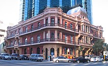
The Palace Hotel in Perth, Western Australia, is a landmark three-storey heritage listed building located in the city's central business district. Originally built in 1897 as a hotel during the gold rush period of Western Australia's history, it was converted to banking chambers and offices in the 1980s and now accommodates the Perth headquarters of Woods Bagot, Adapptor and Hatchd. The building is located on the most prominent intersection in the financial district of the city, at the corner of St Georges Terrace and William Street.
When the hotel opened for business on 18 March 1897 it was, although slightly smaller than some of its contemporary buildings in other capital cities in Australasia, described as "... one of the most beautiful and elegant hotels in Australasia". Other praise included: "... redolent of the bourgeois luxury and splendour of the Paris of Napoleon III" and later "... in its day, as sumptuous a hostelry as any in Melbourne or Sydney." It operated as licensed premises from 1897 until 1981. (Full article...) -
North West Coastal Highway is a generally north-south Western Australian highway which links the coastal city of Geraldton with the town of Port Hedland. The 1,300-kilometre-long (808 mi) road, constructed as a sealed two-lane single carriageway, travels through remote and largely arid landscapes. Carnarvon is the only large settlement on the highway, and is an oasis within the harsh surrounding environment. The entire highway is allocated National Route 1, part of Australia's Highway 1, and parts of the highway are included in tourist routes Batavia Coast Tourist Way and Cossack Tourist Way. Economically, North West Coastal Highway is an important link to the Mid West, Gascoyne and Pilbara regions, supporting the agricultural, pastoral, fishing, and tourism industries, as well as mining and offshore oil and gas production.
In Geraldton, the highway begins at a grade separated interchange with Brand Highway and roads providing access to the port and town centre. Two major roads link the North West Coastal Highway to the inland Great Northern Highway: Geraldton–Mount Magnet Road in Geraldton, and Nanutarra Munjina Road at Nanutarra, 845 kilometres (525 mi) further north. Several roads link provide access to coastal towns and attractions, including Shark Bay Road, Onslow Road and Karratha Road. With few towns on the highway, roadhouses are the only settlements for long stretches. North West Coastal Highway ends at Great Northern Highway, 30 kilometres (19 mi) out from Port Hedland. (Full article...) -
The electoral district of Perth is a Legislative Assembly electorate in the state of Western Australia. Perth is named for the capital city of Western Australia whose central business district falls within its borders. It is one of the oldest electorates in Western Australia, with its first member having been elected in the inaugural 1890 elections of the Legislative Assembly.
Perth has traditionally been a safe Labor seat, but was briefly held by Liberal Eleni Evangel between 2013 and 2017. Perth is currently held by Labor MLA John Carey. (Full article...) -
The Causeway is an arterial traffic crossing in Perth, Western Australia, linking the inner-city suburbs of East Perth and Victoria Park. It is carried over the Swan River at the eastern end of Perth Water by two bridges on either side of Heirisson Island. The current Causeway is the third structure to have been built across the river at this point.
Originally the site of mudflats which restricted river navigation, the Colony Government constructed a causeway and bridge across the site. The project was first planned in 1834 and opened in 1843. When floods in 1862 almost destroyed it, the structure was rebuilt using convict labour, and raised to better withstand future floods. Governor John Hampton officially opened the new Causeway on 12 November 1867. Over the following decades, the three bridges making up this second Causeway were widened several times, and they were eventually replaced in 1952. (Full article...) -

Operation Mosaic was a series of two British nuclear tests conducted in the Montebello Islands in Western Australia on 16 May and 19 June 1956. These tests followed the Operation Totem series and preceded the Operation Buffalo series. The second test in the series was the largest ever conducted in Australia.
The purpose of the tests was to explore increasing the yield of British nuclear weapons through boosting with lithium-6 and deuterium, and the use of a natural uranium tamper. Although a boosted fission weapon is not a hydrogen bomb, which the British Government had agreed would not be tested in Australia, the tests were connected with the British hydrogen bomb programme. (Full article...) -

Abyss is a steel roller coaster located at the Adventure World amusement park in Perth, Western Australia. The $12-million attraction was announced in April 2013, and construction began the following month. It opened to the general public six months later on 1 November 2013.
The Abyss is a Euro-Fighter, a roller coaster model from Gerstlauer that features a "beyond-vertical" first drop which exceeds 90 degrees. In addition to several inversions, the Abyss reaches a top speed of 85 kilometres per hour (53 mph) along the two-minute, 630-metre-long (2,070 ft) ride. (Full article...) -
Clarkson railway station is a suburban rail station in Clarkson, a suburb of Perth, Western Australia. It is on the Yanchep line, which is part of the Transperth network. Located in the median of the Mitchell Freeway, the station consists of an island platform connected to the west by a pedestrian footbridge. A six-stand bus interchange and two carparks are located near the entrance.
Planning for an extension of the Yanchep line (then known as the Joondalup line) north of Currambine station was underway by 1995. The government committed to an extension to Clarkson the following year, and a plan detailing the extension was released in 2000. The first contract for the project, a A$14 million earthworks contract, was awarded to Brierty Contractors in March 2001. In April 2002, Barclay Mowlem and Alstom were awarded a contract worth $17 million to design and build the extension's rail infrastructure, and in November 2002, a $8.7 million contract was awarded to Transfield for the construction of the station. The station opened on 4 October 2004, with five new Transperth B-series trains entering service that day. The following day, bus services in the area were realigned to feed into Clarkson station. On 3 September 2013, there was a minor train crash at Clarkson station. On 21 September 2014, an extension of the Joondalup line 7.5 kilometres (4.7 mi) north to Butler station opened. (Full article...) -
Oats Street railway station is a temporarily-closed Transperth suburban railway station in Western Australia, located in the Perth suburbs of Carlisle and East Victoria Park. The station was served by the Armadale and Thornlie lines prior to its closure in November 2023.
Oats Street station opened on 28 November 1954, as the introduction of diesel railcars made it possible to build stations closer together. The station consisted of two side platforms north of the Oats Street level crossing. The CircleRoute bus began operating in 1998, allowing access to Curtin University from the Armadale line. A bus interchange was constructed soon thereafter, and Oats Street soon became one of the most important stations on the Armadale line. The Thornlie line opened in 2005, with Oats Street station being one of the few transfer stations between the two lines, further increasing its importance. Since 20 November 2023, the station has been closed to allow for the railway to be elevated and for Oats Street station to be rebuilt as an elevated station, as part of the Victoria Park-Canning Level Crossing Removal Project. The new station will straddle Oats Street and feature an expanded bus interchange. It is planned to reopen in mid-2025. (Full article...) -
The West Coast Eagles are an Australian rules football team based in Perth, Western Australia. Their 2019 season was their 33rd season in the Australian Football League (AFL), their sixth season under coach Adam Simpson, and their fifth and final season with Shannon Hurn as captain. Having won the 2018 AFL Grand Final, expectations were that West Coast would finish in the top four on the ladder. They won only three of their first six games, losing by greater than 40 points to the Brisbane Lions, Port Adelaide and Geelong, placing the Eagles 12th on the ladder at the end of round six. They then won 12 of their next 14 games, the losses being to Sydney by 45 points and to Collingwood by 1 point. By the end of round 21, West Coast had been in the top four since round 14, and were aiming to finish in the top two. They then had a disappointing six-point loss to Richmond, and a shock 38-point loss to Hawthorn at home, to finish the season fifth on the ladder. This meant West Coast missed out on the double chance that top four teams get in the AFL finals, significantly lowering their chances of winning the Grand Final. In the 2019 AFL finals series, they faced Essendon in an elimination final, beating them by 55 points, before losing to Geelong in a semi-final by 20 points, ending West Coast's season.
Notable events include Daniel Venables suffering a career-ending concussion in round nine, Nic Naitanui returning from injury in round 15, having been out since round 17, 2018, and Willie Rioli being provisionally suspended before the semi-final after tampering with a drug test. Jack Darling, who kicked 59 goals, was the club's leading goal-scorer for the third time in his career. Darling, Hurn, Jeremy McGovern and Elliot Yeo were selected for the 2020 All-Australian team. Liam Ryan won Mark of the Year for a mark he took in round nine against Melbourne. Luke Shuey was West Coast's best and fairest player, winning the John Worsfold Medal. West Coast fielded a reserves team in the West Australian Football League for the first time in 2019. (Full article...) -
Council House is a 13-storey office building on St Georges Terrace in Perth, Western Australia. Located beside Stirling Gardens and Government House in the city's central business district, the 49.8-metre (163 ft) building was designed by Howlett and Bailey Architects and opened by Queen Elizabeth II in 1963, after Perth hosted the 1962 British Empire and Commonwealth Games. For most of its history, it has served as the headquarters for the City of Perth.
Built in a modernist style, the building has been the subject of vigorous public debate about its heritage value. Some parties, such as the Royal Australian Institute of Architects, consider the building to be an important example of modernist architecture in the city, whilst others consider it ugly. These conflicting views led to animosity in the 1990s, when the State Government refused to heritage list the property, and instead recommended its demolition. Despite this, the City of Perth opted to renovate the tower and keep it as its headquarters. Following this, the building was admitted to the State's Heritage Register. (Full article...)


Did you know (auto-generated)

- ... that Bill Dunn, an Indigenous Australian pastoralist approaching retirement, sold his station at half-price to the Jigalong community despite receiving full-price offers from non-Indigenous people?
- ... that the search for a lost radioactive capsule along a 1,400-kilometre (870 mi) stretch of road in Western Australia was likened to looking for a needle in a haystack?
- ... that Western Australia was the second Australian state to legalise voluntary assisted dying?
- ... that politician John D'Orazio helped to secure a three-year trial of daylight saving time in Western Australia?
- ... that Nick Goiran, a member of the Western Australian Legislative Council, proposed 357 amendments to a voluntary assisted dying bill?
Categories

More portals
More did you know...

- ...that when the 1987 America's Cup was raced off Fremantle, Western Australia it was the first time for 132 years that the regatta had not been hosted by the New York Yacht Club?
- ...that the original Victoria Dam, constructed in 1891, was the first dam in Western Australia, and it stood for almost 100 years before being replaced with the current dam?
- ...that Anglican bishop Kay Goldsworthy was consecrated as the first woman bishop of any Australian church on 22 May 2008?
Related WikiProjects

Things you can do
Here are some tasks you can do to help with WikiProject Western Australia:
Associated Wikimedia
The following Wikimedia Foundation sister projects provide more on this subject:
-
 Commons
Free media repository -
 Wikibooks
Free textbooks and manuals -
 Wikidata
Free knowledge base -
 Wikinews
Free-content news -
 Wikiquote
Collection of quotations -
 Wikisource
Free-content library -
 Wikispecies
Directory of species -
 Wikiversity
Free learning tools -
 Wikivoyage
Free travel guide -
 Wiktionary
Dictionary and thesaurus
-

-

-

-

-

-

-

-

-

-

-
 Random portal
 -


Purge server cache