Harbourton, New Jersey | |
|---|---|
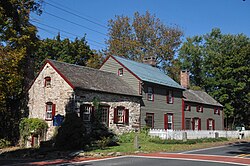
 Old village store in Harbourton. | |
| Coordinates: 40°21′08″N 74°51′08″W / 40.35222°N 74.85222°W | |
| Country | |
| State | |
| County | Mercer |
| Township | Hopewell |
| Elevation | 331 ft (101 m) |
| GNIS feature ID | 876941[1] |
Harbourton is an unincorporated community located within Hopewell Township in Mercer County, in the U.S. state of New Jersey.[2] It is located along County Route 579 at the intersection with Harbourton-Mount Airy Road. The Harbourton Historic District, encompassing the community, was listed on the state and national registers of historic places in 1974.
Historic district[edit]
Harbourton Historic District | |
| Location | Junction of Harbourton/Rocktown and Harbourton/Mt. Airy Roads |
|---|---|
| Area | 7 acres (2.8 ha) |
| Architectural style | Carpenter Gothic |
| NRHP reference No. | 74001167[3] |
| NJRHP No. | 1683[4] |
| Significant dates | |
| Added to NRHP | December 31, 1974 |
| Designated NJRHP | October 25, 1974 |
The Harbourton Historic District is a 7-acre (2.8 ha) historic district encompassing the community around the junction of Harbourton/Rocktown and Harbourton/Mt. Airy Roads. It was added to the National Register of Historic Places on December 31, 1974 for its significance in agriculture, architecture, and commerce. The district includes seven contributing buildings. The oldest section of the village store was built in 1768, and operated as a store until 1962. It is now a private residence. The Baptist Church features Carpenter Gothic architecture.[5]

See also[edit]
References[edit]
- ^ a b "Harbourton". Geographic Names Information System. United States Geological Survey, United States Department of the Interior.
- ^ Locality Search, State of New Jersey. Accessed January 8, 2015.
- ^ "National Register Information System – (#74001167)". National Register of Historic Places. National Park Service. November 2, 2013.
- ^ "New Jersey and National Registers of Historic Places – Mercer County" (PDF). New Jersey Department of Environmental Protection – Historic Preservation Office. December 20, 2022. p. 5.
- ^ Blake, Channing (August 1974). "National Register of Historic Places Inventory/Nomination: Harbourton Historic District". National Park Service. With accompanying 4 photos
External links[edit]
 Media related to Harbourton, New Jersey at Wikimedia Commons
- "Village Store". The Historical Marker Database.


