
Size of this preview: 800 × 587 pixels. Other resolutions: 320 × 235 pixels | 640 × 470 pixels | 955 × 701 pixels.
Original file (955 × 701 pixels, file size: 77 KB, MIME type: image/png)
Summary[edit]
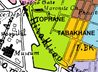
| Description |
Map of the Tabakhane Neighbourhood, Nicosia (1930s) |
|---|---|
| Source |
Constructed using the borders defined in the 1912 Cyprus Gazette and the map of the quarters published by the Dept of Lands and Surveys, drawn on a non-copyright street map from 1930s |
| Date |
June 2014 |
| Author | |
| Permission (Reusing this file) |
See below.
|
- Other information
To accompany the Wikipedia article on Tabakhane Nicosia
Licensing[edit]
I, the copyright holder of this work, hereby publish it under the following licenses:
You may select the license of your choice.
File history
Click on a date/time to view the file as it appeared at that time.
| Date/Time | Thumbnail | Dimensions | User | Comment | |
|---|---|---|---|---|---|
| current | 21:31, 15 June 2014 | | 955 × 701 (77 KB) | Tom1955 (talk | contribs) | Uploading a self-made file using File Upload Wizard |
You cannot overwrite this file.
File usage
The following pages on the English Wikipedia use this file (pages on other projects are not listed):