No higher resolution available.
Praed_Street_-_geograph.org.uk_-_711973.jpg (640 × 418 pixels, file size: 174 KB, MIME type: image/jpeg)
Summary
| Description |
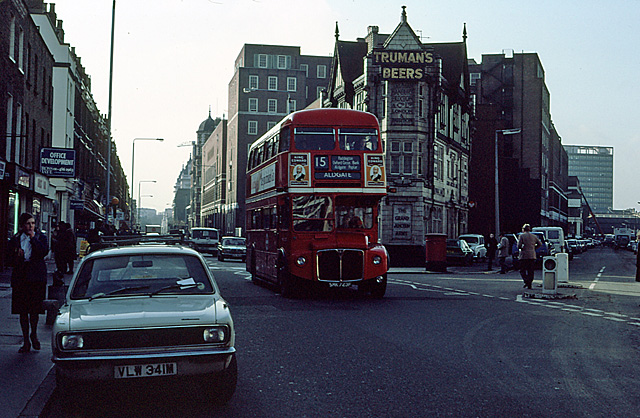
English: Praed Street RML2723 on the 15 route passes the junction with South Wharf Road. Routemasters continue to work on the 15 bus route, but normally only between Hyde Park Corner and Tower Hill. The pub advertising Trumans Beers is the Grand Junction Arms, now closed. |
| Date | |
| Source | From geograph.org.uk |
| Author | Martin Addison |
| Attribution (required by the license) | Martin Addison / Praed Street / |
| Camera location | | View this and other nearby images on: OpenStreetMap |
|---|
_heading:247.00&language=en)
| Object location | | View this and other nearby images on: OpenStreetMap |
|---|
_heading:247.00&language=en)
Licensing

|
This image was taken from the Geograph project collection. See this photograph's page on the Geograph website for the photographer's contact details. The copyright on this image is owned by Martin Addison and is licensed for reuse under the Creative Commons Attribution-ShareAlike 2.0 license.
|
This file is licensed under the Creative Commons Attribution-Share Alike 2.0 Generic license.
Attribution: Martin Addison
- You are free:
- to share – to copy, distribute and transmit the work
- to remix – to adapt the work
- Under the following conditions:
- attribution – You must give appropriate credit, provide a link to the license, and indicate if changes were made. You may do so in any reasonable manner, but not in any way that suggests the licensor endorses you or your use.
- share alike – If you remix, transform, or build upon the material, you must distribute your contributions under the same or compatible license as the original.
File history
Click on a date/time to view the file as it appeared at that time.
| Date/Time | Thumbnail | Dimensions | User | Comment | |
|---|---|---|---|---|---|
| current | 02:08, 19 February 2011 | | 640 × 418 (174 KB) | GeographBot | == {{int:filedesc}} == {{Information |description={{en|1=Praed Street RML2723 on the 15 route passes the junction with South Wharf Road. Routemasters continue to work on the 15 bus route, but normally only between Hyde Park Corner and Tower Hill. The pu |
File usage
The following pages on the English Wikipedia use this file (pages on other projects are not listed):